Difference between revisions of "2017-04-18 48 9"
imported>Drei aus Korb (→Location) |
m |
||
| (11 intermediate revisions by 2 users not shown) | |||
| Line 25: | Line 25: | ||
<!-- who attended: If you link to your wiki user name in this section, your expedition will be picked up by the various statistics generated for geohashing. You may use three tildes ~ as a shortcut to automatically insert the user signature of the account you are editing with. | <!-- who attended: If you link to your wiki user name in this section, your expedition will be picked up by the various statistics generated for geohashing. You may use three tildes ~ as a shortcut to automatically insert the user signature of the account you are editing with. | ||
--> | --> | ||
| + | Mara, Katja & Holger aka [[User:Drei aus Korb|Drei aus Korb]] | ||
== Plans == | == Plans == | ||
<!-- what were the original plans --> | <!-- what were the original plans --> | ||
| + | Well, the hashpoint was not too far away and in the woods...reason enough? | ||
== Expedition == | == Expedition == | ||
<!-- how it all turned out. your narrative goes here. --> | <!-- how it all turned out. your narrative goes here. --> | ||
| − | + | April did what people say April does: Rain, sunshine, snow (not kidding), sunshine, hail,snow, hail, sunshine, rain... | |
| − | + | But the hashpoint was close and not in an industrial area, not on a field or acre, no, in the woods. How could we resist? | |
| − | + | Parked the car at a nearby "Naturfreunde Haus", then walked about 500 metres on a path trough the forrest until we reached the hashpoint. | |
| + | And as allways, the official Geohash Droid on the smart phone didn't do well, whilst we actually were excactly on the spot the app showed us here an there (that's why we normally use GPS devices, but we like it when the app says: you're close enough). | ||
| + | And as often: the app didn't send our proof to the website. | ||
| + | Fortunatly we took screenshots. | ||
== Photos == | == Photos == | ||
| Line 40: | Line 45: | ||
--> | --> | ||
<gallery perrow="5"> | <gallery perrow="5"> | ||
| + | File:Dreiamspot.jpg | Drei am Spot | ||
| + | File:Screenshot 2017-04-18-16-07-17.png | Logproof | ||
| + | File:Nearby1.jpg | Near the Naturfreunde-Haus | ||
| + | File:Whataview.jpg | What a view | ||
| + | File:Therewego.jpg | There we go | ||
| + | File:Hashpoint18.jpg | Hashpoint | ||
| + | File:Whichway.jpg | Which way? | ||
</gallery> | </gallery> | ||
| − | |||
| − | |||
| − | |||
| − | |||
| − | |||
| − | |||
| − | |||
| − | |||
| − | |||
| − | |||
| − | |||
| − | |||
| − | |||
| − | |||
| − | |||
| − | |||
| − | |||
| − | |||
[[Category:Expeditions]] | [[Category:Expeditions]] | ||
| − | |||
[[Category:Expeditions with photos]] | [[Category:Expeditions with photos]] | ||
| − | |||
| − | |||
| − | |||
| − | |||
| − | |||
[[Category:Coordinates reached]] | [[Category:Coordinates reached]] | ||
| − | + | {{location|DE|BW|ES}} | |
| − | |||
| − | |||
| − | |||
| − | |||
| − | |||
| − | |||
| − | |||
| − | |||
| − | |||
| − | |||
| − | |||
| − | |||
| − | |||
| − | |||
| − | |||
| − | |||
| − | |||
Latest revision as of 11:55, 23 September 2021
| Tue 18 Apr 2017 in 48,9: 48.7690718, 9.3747795 geohashing.info google osm bing/os kml crox |
Location
Aichwald; the part of the forrest between Strümpfelbach and Aichelberg
Participants
Mara, Katja & Holger aka Drei aus Korb
Plans
Well, the hashpoint was not too far away and in the woods...reason enough?
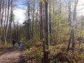
Expedition
April did what people say April does: Rain, sunshine, snow (not kidding), sunshine, hail,snow, hail, sunshine, rain... But the hashpoint was close and not in an industrial area, not on a field or acre, no, in the woods. How could we resist? Parked the car at a nearby "Naturfreunde Haus", then walked about 500 metres on a path trough the forrest until we reached the hashpoint. And as allways, the official Geohash Droid on the smart phone didn't do well, whilst we actually were excactly on the spot the app showed us here an there (that's why we normally use GPS devices, but we like it when the app says: you're close enough). And as often: the app didn't send our proof to the website. Fortunatly we took screenshots.
Photos
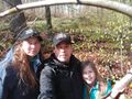
Drei am Spot
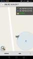
Logproof
Near the Naturfreunde-Haus
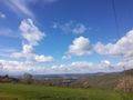
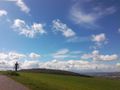
What a view
There we go
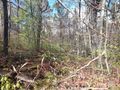
Hashpoint
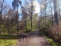
Which way?


