Difference between revisions of "2017-04-22 49 9"
imported>Uvok (Fill details) |
imported>Uvok (Added images) |
||
| Line 38: | Line 38: | ||
<gallery perrow="5"> | <gallery perrow="5"> | ||
| − | Image:2017-04-22_49_9_uvok_1492877535239.jpg|Went to a field near Vilchband. It was really windy. | + | Image:2017-04-22_49_9_uvok_1492877535239.jpg|Went to a field near Vilchband. It was really windy. (Ignore distance, uploaded from home) |
| + | Image:2017-04-22 49 9 uvok panorama.jpeg|A panorama recorded from near the geohash point | ||
| + | Image:2017-04-22 49 9 uvok approach.png|How far I could approach | ||
| + | Image:2017-04-22 49 9 uvok distance tree.jpg|A single tree in the distance | ||
</gallery> | </gallery> | ||
| + | <!-- | ||
== Achievements == | == Achievements == | ||
{{#vardefine:ribbonwidth|800px}} | {{#vardefine:ribbonwidth|800px}} | ||
| − | + | Add any achievement ribbons you earned below, or remove this section --> | |
<!-- =============== USEFUL CATEGORIES FOLLOW ================ | <!-- =============== USEFUL CATEGORIES FOLLOW ================ | ||
Revision as of 19:10, 22 April 2017
| Sat 22 Apr 2017 in 49,9: 49.5860648, 9.8207514 geohashing.info google osm bing/os kml crox |
Location
GeoHashDroid showed me a location near me, so I decided to give it a go. The location was on a field near the small village of Vilchband.
Participants
Plans
Had no plans, it was a rather spontaneous idea.
Expedition
It was nearly 5 p.m. when I arrived, but still light. Turned out Vilchband was bigger than expected. Also, I had no network on the street.
I had to walk upward for a bit to approach the geohash point. It was rather windy and unpleasent. As it turned out, I could only approach the point up to 50 meters, since it was in the middle of a field and I didn't want to step on it.
Photos
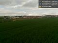
Went to a field near Vilchband. It was really windy. (Ignore distance, uploaded from home)
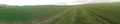
A panorama recorded from near the geohash point
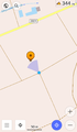
How far I could approach
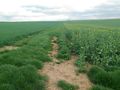
A single tree in the distance


