Difference between revisions of "2017-04-23 49 8"
From Geohashing
imported>DODO (→Photos) |
imported>DODO (→Achievements) |
||
| Line 59: | Line 59: | ||
{{#vardefine:ribbonwidth|800px}} | {{#vardefine:ribbonwidth|800px}} | ||
<!-- Add any achievement ribbons you earned below, or remove this section --> | <!-- Add any achievement ribbons you earned below, or remove this section --> | ||
| − | + | {{land geohash | |
| − | + | | latitude = 49 | |
| − | + | | longitude = 8 | |
| − | + | | date = 2017-04-23 | |
| − | + | | name = [[User:DODO|DODO]] | |
| − | + | }} | |
| − | |||
| − | |||
| − | |||
| − | [[ | ||
| − | |||
| − | |||
| − | |||
| − | |||
| − | |||
[[Category:Expeditions]] | [[Category:Expeditions]] | ||
| − | |||
| − | |||
| − | |||
| − | |||
| − | |||
| − | |||
| − | |||
[[Category:Coordinates reached]] | [[Category:Coordinates reached]] | ||
| − | |||
| − | |||
| − | |||
| − | |||
| − | |||
| − | |||
| − | |||
| − | |||
| − | |||
| − | |||
| − | |||
| − | |||
| − | |||
| − | |||
| − | |||
| − | |||
| − | |||
| − | |||
Revision as of 17:23, 23 April 2017
| Sun 23 Apr 2017 in 49,8: 49.0530963, 8.7363046 geohashing.info google osm bing/os kml crox |
Location
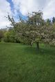
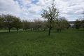
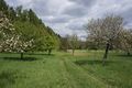
A managed grassland near Gölshausen.
Participants
Plans
Go there by bull.
Expedition
It was cold and windy, but nevertheless a fine ride. It took me almost two hours to ride the 50 KM to the hash. The hash was on an orchard meadow with aple trees, quite easy to reach. I parked the bull, walked 100m took some pictures, returne tothe bull, and ride to the near station in Bretten. Had some cake there and returned home. Pretty easy, but very nice afternoon.
Tracklog
50 KM by bull and 52 KM by train
Photos
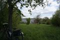
bull and the street I came from
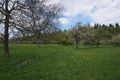
view to the hash
proof
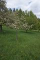
hashtree (yes, the small one)
view to the west
the east (street)
the north (path)

and the hasher
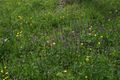
some hashflowers

and - most important - some cake and coffee


Achievements
DODO earned the Land geohash achievement
|