Difference between revisions of "2017-05-11 48 9"
imported>Klaus (template) |
imported>FippeBot m (Location) |
||
| (2 intermediate revisions by one other user not shown) | |||
| Line 1: | Line 1: | ||
| + | [[Image:{{{image|2017-05-11_48_9_180328_view_back.jpg}}}|thumb|left]] | ||
| − | |||
| − | |||
| − | |||
| − | |||
| − | |||
| − | |||
| − | |||
| − | |||
| − | |||
| − | |||
{{meetup graticule | {{meetup graticule | ||
| lat=48 | | lat=48 | ||
| Line 16: | Line 7: | ||
}} | }} | ||
| − | |||
__NOTOC__ | __NOTOC__ | ||
== Location == | == Location == | ||
| − | + | forest near Rübgarten | |
== Participants == | == Participants == | ||
| − | + | * [[User:Klaus|Klaus]] | |
| − | |||
== Plans == | == Plans == | ||
| − | + | Coming back from a business trip early afternoon, I decided spontaneous to make some sports and cycle to the hash. | |
== Expedition == | == Expedition == | ||
| − | + | This was spontaneous, despite me noticing the geohash location the day before. | |
| + | |||
| + | As my business trip was shorter than expected, I was back at home at around 15:30. After putting some cloths in the washing machine, I decided that I could do a nice bicycle tour to the hash. | ||
| + | |||
| + | I started around 17:00 and was back at around 18:50. Not the best time, but I stopped a few times. The whole tour it looked like it would start to rain right now and I noticed some trickling as soon as I started. Luckily, I didn't get wet at all. | ||
| + | |||
| + | My way took me near to [[2015-11-26 48 9]] and was nice, but unspectacular. | ||
| + | Arriving at the hash, I was relieved that it was reachable (the hash lies directly on a river in the map). | ||
| + | The "river" was easily crossable, in fact, I had to do this to get to the very beautiful geohash location! | ||
| − | |||
| − | |||
== Photos == | == Photos == | ||
| − | |||
| − | |||
| − | |||
<gallery perrow="5"> | <gallery perrow="5"> | ||
| + | Image:2017-05-11_48_9_172535_retro_of_2015-11-26_48_9.jpg | View of [[2015-11-26 48 9]] | ||
| + | Image:2017-05-11_48_9_173353_weather.jpg | The weather didn't look good, luckily it didn't rain! | ||
| + | Image:2017-05-11_48_9_175834_proof_transportation.jpg | Proof of Transporation | ||
| + | Image:2017-05-11_48_9_proof.png | Proof (closest I got was ~2m) | ||
| + | Image:2017-05-11_48_9_180143_view_from_hash1.jpg | View from Geohash #1 | ||
| + | Image:2017-05-11_48_9_180148_view_from_hash2.jpg | View from Geohash #2 | ||
| + | Image:2017-05-11_48_9_180152_view_from_hash3.jpg | View from Geohash #3 | ||
| + | Image:2017-05-11_48_9_180200_view_from_hash4.jpg | View from Geohash #4 | ||
| + | Image:2017-05-11_48_9_180209_view_from_hash5.jpg | View from Geohash #5 -- wondering how long this trees will last | ||
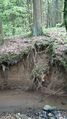
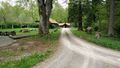
| + | Image:2017-05-11_48_9_180328_view_back.jpg | View back to Geohash. Standing in the small "island" in the middle of this image got me the closest (2m) distance on the GPS. | ||
| + | Image:2017-05-11_48_9_180413_trough_close_to_geohash.jpg | Trough close to Geohash | ||
| + | Image:2017-05-11_48_9_181629_squirrel.jpg | Where's the squirrel?! | ||
| + | Image:2017-05-11_48_9_182051_building_in_forest.jpg | Beautiful located building on my way back. | ||
| + | Image:2017-05-11_48_9_184149_pfrondorf.jpg | Pfrondorf on the way back | ||
</gallery> | </gallery> | ||
== Achievements == | == Achievements == | ||
{{#vardefine:ribbonwidth|800px}} | {{#vardefine:ribbonwidth|800px}} | ||
| − | |||
| − | + | {{land geohash | |
| − | + | | latitude = 48 | |
| − | [[ | + | | longitude = 9 |
| + | | date = 2017-05-11 | ||
| + | | name = [[User:Klaus|Klaus]] | ||
| + | }} | ||
| − | + | {{bicycle geohash | |
| + | | latitude = 48 | ||
| + | | longitude = 9 | ||
| + | | date = 2017-05-11 | ||
| + | | name = [[User:Klaus|Klaus]] | ||
| + | | distance = 23km | ||
| + | | bothways = true | ||
| + | }} | ||
| − | |||
| − | |||
| − | |||
| − | |||
| − | |||
| − | |||
| − | |||
[[Category:Expeditions]] | [[Category:Expeditions]] | ||
| − | |||
[[Category:Expeditions with photos]] | [[Category:Expeditions with photos]] | ||
| − | |||
| − | |||
| − | |||
| − | |||
| − | |||
[[Category:Coordinates reached]] | [[Category:Coordinates reached]] | ||
| − | + | {{location|DE|BW|RT}} | |
| − | |||
| − | |||
| − | |||
| − | |||
| − | |||
| − | |||
| − | |||
| − | |||
| − | |||
| − | |||
| − | |||
| − | |||
| − | |||
| − | |||
| − | |||
| − | |||
| − | |||
Latest revision as of 02:31, 7 August 2019

| Thu 11 May 2017 in 48,9: 48.5782910, 9.1461876 geohashing.info google osm bing/os kml crox |
Location
forest near Rübgarten
Participants
Plans
Coming back from a business trip early afternoon, I decided spontaneous to make some sports and cycle to the hash.
Expedition
This was spontaneous, despite me noticing the geohash location the day before.
As my business trip was shorter than expected, I was back at home at around 15:30. After putting some cloths in the washing machine, I decided that I could do a nice bicycle tour to the hash.
I started around 17:00 and was back at around 18:50. Not the best time, but I stopped a few times. The whole tour it looked like it would start to rain right now and I noticed some trickling as soon as I started. Luckily, I didn't get wet at all.
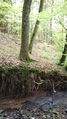
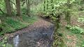
My way took me near to 2015-11-26 48 9 and was nice, but unspectacular. Arriving at the hash, I was relieved that it was reachable (the hash lies directly on a river in the map). The "river" was easily crossable, in fact, I had to do this to get to the very beautiful geohash location!
Photos
View of 2015-11-26 48 9
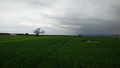
The weather didn't look good, luckily it didn't rain!
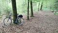
Proof of Transporation
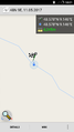
Proof (closest I got was ~2m)
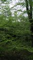
View from Geohash #1
View from Geohash #2
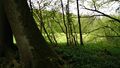
View from Geohash #3
View from Geohash #4
View from Geohash #5 -- wondering how long this trees will last
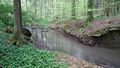
View back to Geohash. Standing in the small "island" in the middle of this image got me the closest (2m) distance on the GPS.
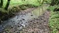
Trough close to Geohash
Where's the squirrel?!
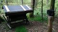
Beautiful located building on my way back.
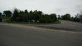
Pfrondorf on the way back


Achievements
Klaus earned the Land geohash achievement
|
Klaus earned the Bicycle geohash achievement
|