Difference between revisions of "2017-05-11 52 1"
From Geohashing
imported>Sourcerer m (→Photos) |
imported>Sourcerer m (→Expedition - Fail) |
||
| Line 21: | Line 21: | ||
== Expedition - Fail == | == Expedition - Fail == | ||
| − | Normally this would have been easy. It was a wheat or barley crop and tractor tracks would lead to the hashpoint. Today there were several farm vehicles preparing to spray the crop and blocking the space where I might have parked. Clearly it would not have been safe to continue. | + | Normally this would have been easy. It was a wheat or barley crop and tractor tracks would lead to the hashpoint. Today there were several farm vehicles preparing to spray the crop and blocking the space where I might have parked. Clearly it would not have been safe to continue. My closest approach was about 50 metres. |
== Photos == | == Photos == | ||
Revision as of 16:33, 11 May 2017
| Thu 11 May 2017 in Norwich, UK: 52.5782910, 1.1461876 geohashing.info google osm bing/os kml crox |
Location
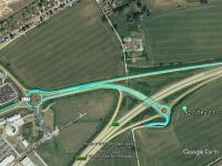
A field just off the A11 at Wymondham, Norfolk, UK.
Participants
Plans
Go after a six mile walk with the Wensum Ramblers only eight miles from the hashpoint.
Expedition - Fail
Normally this would have been easy. It was a wheat or barley crop and tractor tracks would lead to the hashpoint. Today there were several farm vehicles preparing to spray the crop and blocking the space where I might have parked. Clearly it would not have been safe to continue. My closest approach was about 50 metres.
Photos
- Gallery

Achievements
Expeditions and Plans
| 2017-04-21 | ||
|---|---|---|
| Harrisburg, Pennsylvania | Pedalpusher | In the woods off Rt 74 in Dover, PA |
| Norwich, United Kingdom | Sourcerer | A residential street at Claydon, Suffolk, UK. |
| Utrecht, Netherlands | Someone went | In a residential area in Utrecht |
| Bremen, Germany | Kerko | A lake surrounded by fences and walls near Oldenburg. |
Sourcerer's Expedition Links
2017-04-21 52 1 - 2017-05-11 52 1 - 2017-05-13 52 1 - KML file download of Sourcerer's expeditions for use with Google Earth.