Difference between revisions of "2017-05-30 52 9"
From Geohashing
imported>GeorgDerReisende (new report) |
imported>FippeBot m (Location) |
||
| (One intermediate revision by one other user not shown) | |||
| Line 1: | Line 1: | ||
| − | |||
| − | |||
| − | |||
| − | |||
| − | |||
| − | |||
| − | |||
| − | |||
| − | |||
| − | |||
{{meetup graticule | {{meetup graticule | ||
| lat=52 | | lat=52 | ||
| Line 19: | Line 9: | ||
== Location == | == Location == | ||
| − | + | ||
| + | The hash lay some meters away from the motorway junction Berkhof. | ||
== Participants == | == Participants == | ||
| − | + | ||
| − | + | [[User:GeorgDerReisende|GeorgDerReisende]] | |
== Plans == | == Plans == | ||
| − | + | ||
| + | Hitchhiking from Kassel to Hannover, public transport from Hannover to Langenhagen and cycling from Langenhagen to the hash. | ||
== Expedition == | == Expedition == | ||
| − | |||
| − | == | + | {| |
| − | + | |- | |
| + | ! style="width:300px" | !! style="width:300px" | !! style="width:300px" | | ||
| + | |- | ||
| + | | [[Image:2017-05-31 52 9 GeorgDerReisende 5653.jpg|300px]] || colspan = 2 | I left home at 7 o'clock. I started to hitchhike at 7:30 and with two cars I arrived at Laatzen at 10:30. From there I took the tram (city light rail/underground) to Langenhagen and three stops by bus. At Zweirad-Krüger I rented a bike. With this bike I traveled to the hash. I arrived at the motorway junction at 15:50. I found out, that the hash was 17 meters away from the street, a steep slope down and behind a fence. | ||
| + | |- | ||
| + | | [[Image:2017-05-31 52 9 GeorgDerReisende 5853.jpg|300px]] || [[Image:2017-05-31 52 9 GeorgDerReisende 5857.jpg|300px]] || [[Image:2017-05-31 52 9 GeorgDerReisende 5858.jpg|300px]] | ||
| + | |} | ||
| + | |||
| + | Situation at the junction: | ||
| − | |||
| − | |||
| − | |||
| − | |||
<gallery perrow="5"> | <gallery perrow="5"> | ||
| + | Image:2017-05-31 52 9 GeorgDerReisende 5854.jpg | the ramp from the motorway | ||
| + | Image:2017-05-31 52 9 GeorgDerReisende 5855.jpg | county road to the west | ||
| + | Image:2017-05-31 52 9 GeorgDerReisende 5856.jpg | county road to the east | ||
| + | Image:2017-05-31 52 9 GeorgDerReisende 5859.jpg | signs at the junction | ||
| + | Image:2017-05-31 52 9 GeorgDerReisende 5878.jpg | the motorway A7 | ||
</gallery> | </gallery> | ||
| + | |||
| + | {| | ||
| + | |- | ||
| + | | [[Image:2017-05-31 52 9 GeorgDerReisende 5860.jpg|300px]] || [[Image:2017-05-31 52 9 GeorgDerReisende 5867.jpg|300px]] || Behind the hash there was a forest way. I <br>locked the bike to a tree. Then I walked into <br>the bush and reached the hash. And I looked <br>around: | ||
| + | |- | ||
| + | | [[Image:2017-05-31 52 9 GeorgDerReisende 5864.jpg|300px]] <br>to the hash || [[Image:2017-05-31 52 9 GeorgDerReisende 5869.jpg|300px]] <br>to the north || [[Image:2017-05-31 52 9 GeorgDerReisende 5870.jpg|300px]] <br>to the east | ||
| + | |- | ||
| + | | [[Image:2017-05-31 52 9 GeorgDerReisende 5871.jpg|300px]] <br>to the south || [[Image:2017-05-31 52 9 GeorgDerReisende 5872.jpg|300px]] <br>to the west || [[Image:2017-05-31 52 9 GeorgDerReisende 5873.jpg|300px]] <br>and to the geohasher. | ||
| + | |} | ||
| + | |||
| + | Then I tried to cycle back to the bike shop. But as I had already 13 kilometers to go I was too tired and I took the train from Mellendorf to Langenhagen. | ||
== Achievements == | == Achievements == | ||
| Line 45: | Line 56: | ||
<!-- Add any achievement ribbons you earned below, or remove this section --> | <!-- Add any achievement ribbons you earned below, or remove this section --> | ||
| − | + | {{land geohash | latitude = 52 | longitude = 9 | date = 2017-05-30 | name = GeorgDerReisende }} | |
| − | |||
| − | |||
| − | + | [[Category:Expeditions]] | |
| − | + | [[Category:Expeditions with photos]] | |
| − | |||
| − | [[Category: | ||
| − | |||
| − | |||
| − | |||
| − | |||
| − | |||
| − | |||
| − | |||
| − | |||
| − | |||
| − | |||
| − | |||
| − | |||
[[Category:Coordinates reached]] | [[Category:Coordinates reached]] | ||
| − | + | {{location|DE|NI|H}} | |
| − | |||
| − | |||
| − | |||
| − | |||
| − | |||
| − | |||
| − | |||
| − | |||
| − | |||
| − | |||
| − | |||
| − | |||
| − | |||
| − | |||
| − | |||
| − | |||
| − | |||
Latest revision as of 02:34, 16 August 2019
| Tue 30 May 2017 in 52,9: 52.6097063, 9.7360220 geohashing.info google osm bing/os kml crox |
Location
The hash lay some meters away from the motorway junction Berkhof.
Participants
Plans
Hitchhiking from Kassel to Hannover, public transport from Hannover to Langenhagen and cycling from Langenhagen to the hash.
Expedition
 |
I left home at 7 o'clock. I started to hitchhike at 7:30 and with two cars I arrived at Laatzen at 10:30. From there I took the tram (city light rail/underground) to Langenhagen and three stops by bus. At Zweirad-Krüger I rented a bike. With this bike I traveled to the hash. I arrived at the motorway junction at 15:50. I found out, that the hash was 17 meters away from the street, a steep slope down and behind a fence. | |
 |
 |

|
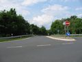
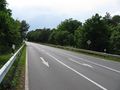
Situation at the junction:
the ramp from the motorway
county road to the west
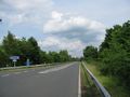
county road to the east
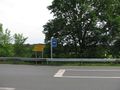
signs at the junction
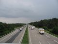
the motorway A7


 |
 |
Behind the hash there was a forest way. I locked the bike to a tree. Then I walked into the bush and reached the hash. And I looked around: |
 to the hash |
 to the north |
 to the east |
 to the south |
 to the west |
 and to the geohasher. |
Then I tried to cycle back to the bike shop. But as I had already 13 kilometers to go I was too tired and I took the train from Mellendorf to Langenhagen.
Achievements
GeorgDerReisende earned the Land geohash achievement
|