imported>Hijackal |
imported>Hijackal |
| Line 1: |
Line 1: |
| − |
| |
| − | <!-- If you did not specify these parameters in the template, please substitute appropriate values for IMAGE, LAT, LON, and DATE (YYYY-MM-DD format)
| |
| − |
| |
| − | [[Image:{{{image|IMAGE}}}|thumb|left]]
| |
| − |
| |
| − | Remove this section if you don't want an image at the top (left) of your report. You should remove the "Image:" or "File:"
| |
| − | tag from your image file name, and replace the all upper-case word IMAGE in the above line.
| |
| − |
| |
| − | And DON'T FORGET to add your expedition and the best photo you took to the gallery on the Main Page! We'd love to read your report, but that means we first have to discover it! :)
| |
| − | -->
| |
| | {{meetup graticule | | {{meetup graticule |
| | | lat=48 | | | lat=48 |
| Line 15: |
Line 5: |
| | }} | | }} |
| | | | |
| − | <!-- edit as necessary -->
| |
| | __NOTOC__ | | __NOTOC__ |
| | | | |
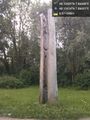
| | == Location == | | == Location == |
| − | <!-- where you've surveyed the hash to be -->
| + | A park in Emmendingen |
| | | | |
| | == Participants == | | == Participants == |
| − | <!-- who attended: If you link to your wiki user name in this section, your expedition will be picked up by the various statistics generated for geohashing. You may use three tildes ~ as a shortcut to automatically insert the user signature of the account you are editing with.
| + | [[User:Hijackal|Hijackal]] |
| − | -->
| |
| | | | |
| | == Plans == | | == Plans == |
| − | <!-- what were the original plans -->
| + | Just about to scavenge the freezer for food, Hijackal realizes that his last three days have been very strange. Lots of stress and unusual cirumstances, lots of people and lots of talk - but not enough play, the only physical difficulty being the constant changes between air conditioning, humid summer and thunderstorms. |
| | + | Amazingly, the hash turns out to be roughly six km from home! Hijackal decides to run. |
| | | | |
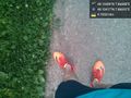
| | == Expedition == | | == Expedition == |
| − | <!-- how it all turned out. your narrative goes here. -->
| + | After some rain, its reasonably cool at 19:00, and running is nice. The hash is easily found, and Hijackal briefly considers a Tron, but gives up due to abundance of rivers and lack of bridges. A spontaneous half marathon doesn't seem the sensible thing to do. |
| | | | |
| − |
| |
| − | *Spontaneous run -- [[User:Hijackal|Hijackal]] ([[User talk:Hijackal|talk]]) [http://www.openstreetmap.org/?lat=48.10416880&lon=7.86677420&zoom=16&layers=B000FTF @48.1042,7.8668] 20:36, 31 May 2017 (GMT+02:00)
| |
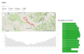
| | == Tracklog == | | == Tracklog == |
| − | <!-- if your GPS device keeps a log, you may post a link here -->
| + | see gallery for image. |
| | | | |
| | == Photos == | | == Photos == |
| Line 49: |
Line 36: |
| | </gallery> | | </gallery> |
| | | | |
| − | == Achievements ==
| |
| − | {{#vardefine:ribbonwidth|800px}}
| |
| − | <!-- Add any achievement ribbons you earned below, or remove this section -->
| |
| − |
| |
| − | <!-- =============== USEFUL CATEGORIES FOLLOW ================
| |
| − | Delete the next line ONLY if you have chosen the appropriate categories below. If you are unsure, don't worry. People will read your report and help you with the classification. -->
| |
| − | [[Category:New report]]
| |
| − |
| |
| − | <!-- ==REQUEST FOR TWITTER BOT== Please leave either the New report or the Expedition planning category in as long as you work on it. This helps the twitter bot a lot with announcing the right outcome at the right moment. -->
| |
| − |
| |
| − | <!-- Potential categories. Please include all the ones appropriate to your expedition -->
| |
| − | <!-- If this is a planning page:
| |
| − | [[Category:Expedition planning]]
| |
| − | -->
| |
| − |
| |
| − | <!-- If all those plans are never acted upon, change [[Category:Expedition planning]] to [[Category:Not reached - Did not attempt]]. -->
| |
| − |
| |
| − | <!-- An actual expedition:
| |
| | [[Category:Expeditions]] | | [[Category:Expeditions]] |
| − | -- and one or more of --
| |
| | [[Category:Expeditions with photos]] | | [[Category:Expeditions with photos]] |
| − | [[Category:Expeditions with videos]]
| + | |
| − | [[Category:Expedition without GPS]]
| |
| − | -->
| |
| − |
| |
| − | <!-- if you reached your coords:
| |
| | [[Category:Coordinates reached]] | | [[Category:Coordinates reached]] |
| − |
| |
| − |
| |
| − | --><!-- or if you failed :(
| |
| − | [[Category:Coordinates not reached]]
| |
| − | -- and a reason --
| |
| − | When there is a natural obstacle between you and the target:
| |
| − | [[Category:Not reached - Mother Nature]]
| |
| − |
| |
| − | When there is a man-made obstacle between you and the target:
| |
| − | [[Category:Not reached - No public access]]
| |
| − |
| |
| − | When you failed get your GPS, car, bike or such to work:
| |
| − | [[Category:Not reached - Technology]]
| |
| − |
| |
| − | When you went to an alternate location instead of the actual geohash:
| |
| − | [[Category:Not reached - Attended alternate location]]
| |
| − |
| |
| − | (Don't forget to delete this final close comment marker) -->
| |
Location
A park in Emmendingen
Participants
Hijackal
Plans
Just about to scavenge the freezer for food, Hijackal realizes that his last three days have been very strange. Lots of stress and unusual cirumstances, lots of people and lots of talk - but not enough play, the only physical difficulty being the constant changes between air conditioning, humid summer and thunderstorms.
Amazingly, the hash turns out to be roughly six km from home! Hijackal decides to run.
Expedition
After some rain, its reasonably cool at 19:00, and running is nice. The hash is easily found, and Hijackal briefly considers a Tron, but gives up due to abundance of rivers and lack of bridges. A spontaneous half marathon doesn't seem the sensible thing to do.
Tracklog
see gallery for image.
Photos