Difference between revisions of "2017-06-02 47 -119"
imported>Thomcat ([live picture]Zekesville [http://www.openstreetmap.org/?lat=47.83378990&lon=-121.64236990&zoom=16&layers=B000FTF @47.8338,-121.6424]) |
(Expedition details, finally) |
||
| (4 intermediate revisions by 3 users not shown) | |||
| Line 1: | Line 1: | ||
| − | |||
<!-- If you did not specify these parameters in the template, please substitute appropriate values for IMAGE, LAT, LON, and DATE (YYYY-MM-DD format) | <!-- If you did not specify these parameters in the template, please substitute appropriate values for IMAGE, LAT, LON, and DATE (YYYY-MM-DD format) | ||
| Line 13: | Line 12: | ||
| lon=-119 | | lon=-119 | ||
| date=2017-06-02 | | date=2017-06-02 | ||
| + | | graticule_name=Moses Lake | ||
| + | | graticule_link=Moses Lake, Washington | ||
}} | }} | ||
| Line 20: | Line 21: | ||
== Location == | == Location == | ||
<!-- where you've surveyed the hash to be --> | <!-- where you've surveyed the hash to be --> | ||
| + | Just south of Highway 2, east of Waterville | ||
== Participants == | == Participants == | ||
<!-- who attended: If you link to your wiki user name in this section, your expedition will be picked up by the various statistics generated for geohashing. You may use three tildes ~ as a shortcut to automatically insert the user signature of the account you are editing with. | <!-- who attended: If you link to your wiki user name in this section, your expedition will be picked up by the various statistics generated for geohashing. You may use three tildes ~ as a shortcut to automatically insert the user signature of the account you are editing with. | ||
--> | --> | ||
| + | * [[User:Thomcat|Thomcat]] | ||
== Plans == | == Plans == | ||
<!-- what were the original plans --> | <!-- what were the original plans --> | ||
| + | Okay, wow, this is an old one. Plans were to drive across the state on highway 2 and stop at the geohashpoint. Zeke's drive-in was the first stop on the way. | ||
== Expedition == | == Expedition == | ||
<!-- how it all turned out. your narrative goes here. --> | <!-- how it all turned out. your narrative goes here. --> | ||
| + | ===2017=== | ||
| + | I do remember this spot had no internet whatsoever - and the "plunger" message refers to the app being stuck so I couldn't send any messages (or wikiedits). So time to dig up the camera and see what it shows - including hopefully a screenshot. I did achieve the geohash on the subsequent day, so it is likely - but we shall see... | ||
*On the way -- [[User:Thomcat|Thomcat]] ([[User talk:Thomcat|talk]]) [http://www.openstreetmap.org/?lat=47.85531580&lon=-121.89066420&zoom=16&layers=B000FTF @47.8553,-121.8907] 14:49, 2 June 2017 (PDT) | *On the way -- [[User:Thomcat|Thomcat]] ([[User talk:Thomcat|talk]]) [http://www.openstreetmap.org/?lat=47.85531580&lon=-121.89066420&zoom=16&layers=B000FTF @47.8553,-121.8907] 14:49, 2 June 2017 (PDT) | ||
| + | |||
| + | *Test plunger message -- [[User:Thomcat|Thomcat]] ([[User talk:Thomcat|talk]]) 13:57, 5 June 2017 (PDT) | ||
| + | |||
| + | ===2021=== | ||
| + | Spurred by this showing up in the count, despite my name *not* being under Participants, I dug into my photos folder to find the evidence. | ||
| + | A picture is worth 1000 words (YMMV), but here's the story in text form. | ||
| + | |||
| + | My hapless Nexus had no LTE signal in this 2017 deadzone. It has improved somewhat since. | ||
| + | |||
| + | The surveyed hashpoint was south of the road. If a field of weeds or stubble, worth a walk - but it was not. In the long-standing tradition of geohashers who refuse to trample food, future bread or beer, I called the expedition a success by parking and chalking just north of the point. | ||
| + | |||
| + | The EXIF data from the photos indicates I am a few meters off directly north, assuming the GPS they were measuring was correctly reported at the time. I did *not* find a screenshot of the expedition, alas. | ||
| + | |||
| + | Finally, and coincidentally, my most recent geohash attempt was also in this graticule, three east from my normal home. My first attempt here, more than 13 years ago, involved tracking through a harvested field to the exact point. | ||
| + | |||
== Tracklog == | == Tracklog == | ||
<!-- if your GPS device keeps a log, you may post a link here --> | <!-- if your GPS device keeps a log, you may post a link here --> | ||
| Line 43: | Line 64: | ||
Image:2017-06-02_47_-119_thomcat_1496441597798.jpg|Zekesville [http://www.openstreetmap.org/?lat=47.83378990&lon=-121.64236990&zoom=16&layers=B000FTF @47.8338,-121.6424] | Image:2017-06-02_47_-119_thomcat_1496441597798.jpg|Zekesville [http://www.openstreetmap.org/?lat=47.83378990&lon=-121.64236990&zoom=16&layers=B000FTF @47.8338,-121.6424] | ||
| − | |||
| − | |||
| − | |||
| − | |||
| − | |||
| − | + | Image:2017-06-02 47 -119 Car.jpg | Marks by the car | |
| − | |||
| − | |||
| − | + | Image:2017-06-02 47 -119 Field.jpg | The growing crops in question | |
| − | + | Image:2017-06-02 47 -119 Geohasher.jpg | Our intrepid geohasher | |
| − | |||
| − | |||
| − | |||
| − | < | + | </gallery> |
| − | + | == Achievements == | |
| + | {{#vardefine:ribbonwidth|800px}} | ||
[[Category:Expeditions]] | [[Category:Expeditions]] | ||
| − | |||
[[Category:Expeditions with photos]] | [[Category:Expeditions with photos]] | ||
| − | |||
| − | |||
| − | |||
| − | |||
| − | |||
[[Category:Coordinates reached]] | [[Category:Coordinates reached]] | ||
| − | + | {{location|US|WA|DO}} | |
| − | |||
| − | |||
| − | |||
| − | |||
| − | |||
| − | |||
| − | |||
| − | |||
| − | |||
| − | |||
| − | |||
| − | |||
| − | |||
| − | |||
| − | |||
| − | |||
Latest revision as of 21:29, 23 August 2021
| Fri 2 Jun 2017 in Moses Lake: 47.6104995, -119.8721256 geohashing.info google osm bing/os kml crox |
Location
Just south of Highway 2, east of Waterville
Participants
Plans
Okay, wow, this is an old one. Plans were to drive across the state on highway 2 and stop at the geohashpoint. Zeke's drive-in was the first stop on the way.
Expedition
2017
I do remember this spot had no internet whatsoever - and the "plunger" message refers to the app being stuck so I couldn't send any messages (or wikiedits). So time to dig up the camera and see what it shows - including hopefully a screenshot. I did achieve the geohash on the subsequent day, so it is likely - but we shall see...
- On the way -- Thomcat (talk) @47.8553,-121.8907 14:49, 2 June 2017 (PDT)
2021
Spurred by this showing up in the count, despite my name *not* being under Participants, I dug into my photos folder to find the evidence. A picture is worth 1000 words (YMMV), but here's the story in text form.
My hapless Nexus had no LTE signal in this 2017 deadzone. It has improved somewhat since.
The surveyed hashpoint was south of the road. If a field of weeds or stubble, worth a walk - but it was not. In the long-standing tradition of geohashers who refuse to trample food, future bread or beer, I called the expedition a success by parking and chalking just north of the point.
The EXIF data from the photos indicates I am a few meters off directly north, assuming the GPS they were measuring was correctly reported at the time. I did *not* find a screenshot of the expedition, alas.
Finally, and coincidentally, my most recent geohash attempt was also in this graticule, three east from my normal home. My first attempt here, more than 13 years ago, involved tracking through a harvested field to the exact point.
Tracklog
Photos
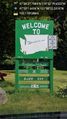
Zekesville @47.8338,-121.6424
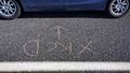
Marks by the car
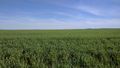
The growing crops in question

Our intrepid geohasher


