Difference between revisions of "2017-06-03 47 -118"
imported>Thomcat ([live picture]Welcome to Wilbur [http://www.openstreetmap.org/?lat=47.76053110&lon=-118.71319510&zoom=16&layers=B000FTF @47.7605,-118.7132]) |
imported>FippeBot m (Location) |
||
| (7 intermediate revisions by one other user not shown) | |||
| Line 1: | Line 1: | ||
| − | |||
| − | |||
| − | |||
| − | |||
| − | |||
| − | |||
| − | |||
| − | |||
| − | |||
| − | |||
{{meetup graticule | {{meetup graticule | ||
| lat=47 | | lat=47 | ||
| lon=-118 | | lon=-118 | ||
| date=2017-06-03 | | date=2017-06-03 | ||
| + | | graticule_name=Davenport | ||
| + | | graticule_link=Davenport, Washington | ||
}} | }} | ||
| Line 19: | Line 11: | ||
== Location == | == Location == | ||
| − | + | Northwest along highway 174 between Wilbur and Grand Coulee Dam | |
== Participants == | == Participants == | ||
| − | + | * [[User:Thomcat|Thomcat]] | |
| − | + | ||
| + | == Expedition == | ||
| + | Returning from a brief visit to Spokane, this geohash was basically on the way. I took highway 2 west from Spokane, then upon reaching Wilbur, took state highway 174 to the northwest. The actual hashpoint was exactly 100 miles from when I gassed up this morning in the Spokane valley. | ||
| + | |||
| + | I passed the spot and tried to pull over, but the shoulder was incredibly soft - I couldn't get the hash vehicle far enough off the road for safety. Pulling back onto the highway, I continued about 200 meters up the road to a wide spot and parked there. | ||
| + | |||
| + | Passing an incredible array of trash and some rather large burrow entrances, I easily reached said geohashpoint. Growing in the field nearby was some lovely spring wheat, but no traipsing into the field required for this point. Also unlike my previous attempt, this point had full cell signal from the nearby town of Wilbur Washington. | ||
| − | + | Satisfied in my attempt, I returned to my vehicle and continued my trip to Seattle. | |
| − | |||
| − | + | Statistics - three geohashes in the Davenport graticule, all by me, all in wheat fields, with the first back in 2009. | |
| − | |||
== Tracklog == | == Tracklog == | ||
| Line 41: | Line 37: | ||
Image:2017-06-03_47_-118_thomcat_1496524884276.jpg|Welcome to Wilbur [http://www.openstreetmap.org/?lat=47.76053110&lon=-118.71319510&zoom=16&layers=B000FTF @47.7605,-118.7132] | Image:2017-06-03_47_-118_thomcat_1496524884276.jpg|Welcome to Wilbur [http://www.openstreetmap.org/?lat=47.76053110&lon=-118.71319510&zoom=16&layers=B000FTF @47.7605,-118.7132] | ||
| + | |||
| + | Image:2017-06-03_47_-118_thomcat_1496525282709.jpg|Parking [http://www.openstreetmap.org/?lat=47.78651490&lon=-118.73992990&zoom=16&layers=B000FTF @47.7865,-118.7399] | ||
| + | |||
| + | Image:2017-06-03_47_-118_thomcat_1496525331528.jpg|More wheat [http://www.openstreetmap.org/?lat=47.78611000&lon=-118.73947310&zoom=16&layers=B000FTF @47.7861,-118.7395] | ||
| + | |||
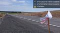
| + | Image:2017-06-03_47_-118_thomcat_1496525576907.jpg|First stop [http://www.openstreetmap.org/?lat=47.78419270&lon=-118.73727890&zoom=16&layers=B000FTF @47.7842,-118.7373] | ||
| + | |||
| + | Image:2017-06-03_47_-118_thomcat_1496525730022.jpg|Hash post [http://www.openstreetmap.org/?lat=47.78413710&lon=-118.73716700&zoom=16&layers=B000FTF @47.7841,-118.7372] | ||
| + | |||
| + | Image:2017-06-03_47_-118_thomcat_1496525803360.jpg|Geohasher [http://www.openstreetmap.org/?lat=47.78414100&lon=-118.73718430&zoom=16&layers=B000FTF @47.7841,-118.7372] | ||
| + | |||
| + | Image:2017-06-03_47_-118_thomcat_1496525881044.jpg|Wilbur in the distance [http://www.openstreetmap.org/?lat=47.78414410&lon=-118.73719550&zoom=16&layers=B000FTF @47.7841,-118.7372] | ||
</gallery> | </gallery> | ||
| Line 47: | Line 55: | ||
<!-- Add any achievement ribbons you earned below, or remove this section --> | <!-- Add any achievement ribbons you earned below, or remove this section --> | ||
| − | |||
| − | |||
| − | |||
| − | |||
| − | |||
| − | |||
| − | |||
| − | |||
| − | |||
| − | |||
| − | |||
| − | |||
| − | |||
| − | |||
[[Category:Expeditions]] | [[Category:Expeditions]] | ||
| − | |||
[[Category:Expeditions with photos]] | [[Category:Expeditions with photos]] | ||
| − | |||
| − | |||
| − | |||
| − | |||
| − | |||
[[Category:Coordinates reached]] | [[Category:Coordinates reached]] | ||
| − | + | {{location|US|WA|LI}} | |
| − | |||
| − | |||
| − | |||
| − | |||
| − | |||
| − | |||
| − | |||
| − | |||
| − | |||
| − | |||
| − | |||
| − | |||
| − | |||
| − | |||
| − | |||
| − | |||
| − | |||
Latest revision as of 02:32, 7 August 2019
| Sat 3 Jun 2017 in Davenport: 47.7841287, -118.7371669 geohashing.info google osm bing/os kml crox |
Location
Northwest along highway 174 between Wilbur and Grand Coulee Dam
Participants
Expedition
Returning from a brief visit to Spokane, this geohash was basically on the way. I took highway 2 west from Spokane, then upon reaching Wilbur, took state highway 174 to the northwest. The actual hashpoint was exactly 100 miles from when I gassed up this morning in the Spokane valley.
I passed the spot and tried to pull over, but the shoulder was incredibly soft - I couldn't get the hash vehicle far enough off the road for safety. Pulling back onto the highway, I continued about 200 meters up the road to a wide spot and parked there.
Passing an incredible array of trash and some rather large burrow entrances, I easily reached said geohashpoint. Growing in the field nearby was some lovely spring wheat, but no traipsing into the field required for this point. Also unlike my previous attempt, this point had full cell signal from the nearby town of Wilbur Washington.
Satisfied in my attempt, I returned to my vehicle and continued my trip to Seattle.
Statistics - three geohashes in the Davenport graticule, all by me, all in wheat fields, with the first back in 2009.
Tracklog
Photos
Welcome to Wilbur @47.7605,-118.7132
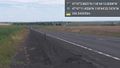
Parking @47.7865,-118.7399
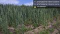
More wheat @47.7861,-118.7395
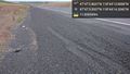
First stop @47.7842,-118.7373
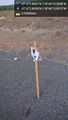
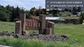
Hash post @47.7841,-118.7372
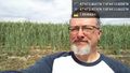
Geohasher @47.7841,-118.7372
Wilbur in the distance @47.7841,-118.7372


