Difference between revisions of "2017-06-17 60 24"
imported>PPP (An expedition message sent via Geohash Droid for Android.) |
imported>FippeBot m (Location) |
||
| (12 intermediate revisions by 2 users not shown) | |||
| Line 19: | Line 19: | ||
== Location == | == Location == | ||
| − | <!-- where you've surveyed the hash to be --> | + | Helsinki Kaarela Malminkartano in the edge bushes of Mätäoja creek <!-- where you've surveyed the hash to be --> |
== Participants == | == Participants == | ||
<!-- who attended: If you link to your wiki user name in this section, your expedition will be picked up by the various statistics generated for geohashing. You may use three tildes ~ as a shortcut to automatically insert the user signature of the account you are editing with. | <!-- who attended: If you link to your wiki user name in this section, your expedition will be picked up by the various statistics generated for geohashing. You may use three tildes ~ as a shortcut to automatically insert the user signature of the account you are editing with. | ||
--> | --> | ||
| + | [[User:PPP|PPP]] ([[User talk:PPP|talk]]) 15:44, 18 June 2017 (UTC) | ||
== Plans == | == Plans == | ||
<!-- what were the original plans --> | <!-- what were the original plans --> | ||
| + | None - Noticed day earlier that Saturdays 60 24 will be reachable by bike and the weather according to forecast will be suitable for cycling. | ||
== Expedition == | == Expedition == | ||
<!-- how it all turned out. your narrative goes here. --> | <!-- how it all turned out. your narrative goes here. --> | ||
| + | Not that much story to tell. It was nice cycle trip in the cycleways trough the woods and fields totalling 57 km. Had to cycle bit more than planned 17 km to zero spot because I (knowingly) cycled alongside the wrong railway track. Despite of that my Garmin EDGE 810 routed me helpfully to correct area aided by my general knowledge of the best cycleways (in the very edge of my known area actually). | ||
| + | |||
| + | For the final approach I used Geohash Droid and got green ~10m before I had to go to high grass and bushes where ticks live. | ||
== Tracklog == | == Tracklog == | ||
| Line 39: | Line 44: | ||
--> | --> | ||
<gallery perrow="5"> | <gallery perrow="5"> | ||
| + | |||
| + | Image:2017-06-17_60_24_PPP_1497714761142.jpg|Done this - more to follow (I send this once earlier directly from the location, but it never arrived - strange?) | ||
| + | |||
| + | Image:2017-06-17 60 24 PPP 3.jpg|There it is | ||
| + | |||
| + | Image:2017-06-17 60 24 PPP 1.jpg|Second device showing zero | ||
| + | |||
| + | Image:2017-06-17 60 24 PPP 2.jpg|The tick check - none found, only dirt from wet roads | ||
</gallery> | </gallery> | ||
| Line 45: | Line 58: | ||
<!-- Add any achievement ribbons you earned below, or remove this section --> | <!-- Add any achievement ribbons you earned below, or remove this section --> | ||
| − | + | {{Bicycle geohash | latitude = 60 | longitude = 24 | date = 2017-06-17 | name = PPP | distance = 53 km | bothways = true | image = 2017-06-17 60 24 PPP 3.jpg }} | |
| − | |||
| − | |||
| − | |||
| − | |||
| − | |||
| − | |||
| − | |||
| − | |||
| − | |||
| − | |||
| − | |||
| − | |||
[[Category:Expeditions]] | [[Category:Expeditions]] | ||
| − | |||
[[Category:Expeditions with photos]] | [[Category:Expeditions with photos]] | ||
| − | |||
| − | |||
| − | |||
| − | |||
| − | |||
[[Category:Coordinates reached]] | [[Category:Coordinates reached]] | ||
| − | + | {{location|FI|18}} | |
| − | |||
| − | |||
| − | |||
| − | |||
| − | |||
| − | |||
| − | |||
| − | |||
| − | |||
| − | |||
| − | |||
| − | |||
| − | |||
| − | |||
| − | |||
| − | |||
| − | |||
Latest revision as of 18:31, 26 July 2019
| Sat 17 Jun 2017 in 60,24: 60.2498999, 24.8758094 geohashing.info google osm bing/os kml crox |
Location
Helsinki Kaarela Malminkartano in the edge bushes of Mätäoja creek
Participants
PPP (talk) 15:44, 18 June 2017 (UTC)
Plans
None - Noticed day earlier that Saturdays 60 24 will be reachable by bike and the weather according to forecast will be suitable for cycling.
Expedition
Not that much story to tell. It was nice cycle trip in the cycleways trough the woods and fields totalling 57 km. Had to cycle bit more than planned 17 km to zero spot because I (knowingly) cycled alongside the wrong railway track. Despite of that my Garmin EDGE 810 routed me helpfully to correct area aided by my general knowledge of the best cycleways (in the very edge of my known area actually).
For the final approach I used Geohash Droid and got green ~10m before I had to go to high grass and bushes where ticks live.
Tracklog
Photos
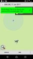
Done this - more to follow (I send this once earlier directly from the location, but it never arrived - strange?)
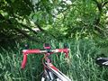
There it is
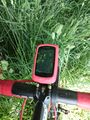
Second device showing zero
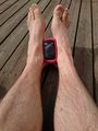
The tick check - none found, only dirt from wet roads


Achievements
PPP earned the Bicycle geohash achievement
|