Difference between revisions of "2017-06-23 31 34"
imported>FippeBot m (Location) |
m |
||
| Line 61: | Line 61: | ||
<!-- Add any achievement ribbons you earned below, or remove this section --> | <!-- Add any achievement ribbons you earned below, or remove this section --> | ||
| − | + | [[Category:Expeditions]] | |
| − | |||
| − | |||
| − | |||
| − | |||
| − | |||
| − | |||
| − | |||
| − | |||
| − | |||
| − | |||
| − | |||
[[Category:Expeditions with photos]] | [[Category:Expeditions with photos]] | ||
| − | |||
| − | |||
| − | |||
| − | |||
| − | |||
| − | |||
| − | |||
| − | |||
[[Category:Coordinates reached]] | [[Category:Coordinates reached]] | ||
| − | |||
| − | |||
| − | |||
| − | |||
| − | |||
| − | |||
| − | |||
| − | |||
| − | |||
| − | |||
| − | |||
| − | |||
| − | |||
| − | |||
| − | |||
| − | |||
| − | |||
| − | |||
| − | |||
| − | |||
| − | |||
{{location|IL|M|RH}} | {{location|IL|M|RH}} | ||
Latest revision as of 12:11, 23 September 2021
2017-06-23 31 34
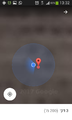
| Fri 23 Jun 2017 in 31,34: 31.8271418, 34.7275786 geohashing.info google osm bing/os kml crox |
Location
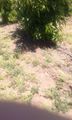
This happened to be in an avocado field south of Kfar Aviv.
Participants
Plans
There was a two-fold plan. I asked my friend Moshe if he wanted to give a point a shot and he said he wanted to try Mitzpe Ramon. He sprained his toe, so I went alone from Netivot to Kfar Aviv. I basically planned the trip with my wife on the bus from Jerusalem to Netivot. The plan was to take the train from Netivot to Yavne Ma'arav, and then take the Metropolin 369 to Beit Raban Junction. From there I would walk across the fields if I received permission.
Expedition
I ended up receiving permission from someone working on the farm. On the way back I got two hitches from Beit Raban Junction to the train station in Ashdod and then I took the train home. I visited Moshe that evening.
Tracklog
Doesn't have coordinates but within error

Photos
one avocado tree
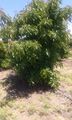
another avocado tree
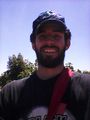
This is me


