Difference between revisions of "2017-07-06 52 4"
imported>FelixTheCat (Replaced content with "{{subst:Expedition |lat = 52 |lon = 4 |date = 2017-07-06 }}") |
imported>FelixTheCat |
||
| Line 1: | Line 1: | ||
| − | |||
| − | |||
| − | |||
| − | |||
| − | |||
| − | |||
| − | |||
| − | |||
| − | |||
| − | |||
{{meetup graticule | {{meetup graticule | ||
| lat=52 | | lat=52 | ||
| Line 14: | Line 4: | ||
| date=2017-07-06 | | date=2017-07-06 | ||
}} | }} | ||
| − | |||
| − | |||
__NOTOC__ | __NOTOC__ | ||
| − | |||
== Location == | == Location == | ||
| − | + | Raamweg, between numbers 46 and 47, The Hague. | |
== Participants == | == Participants == | ||
| − | + | [[User:FelixTheCat|FelixTheCat]] ([[User talk:FelixTheCat|talk]]) | |
| − | |||
| − | |||
| − | |||
| − | |||
== Expedition == | == Expedition == | ||
| − | + | Today's hash appeared to be on a publicly accessible place in The Hague. I decided to cycle there after work. The weather was nice but very humid, and clouds were rolling in. The city centre was busy with commuters going home after work. Riding along the Raamweg (a major road connecting the city centre to the northern neighbourhoods) I watched as the distance indicator on my GPS slowly counted down. The hash was located just on the side of the road, close to the main building of the Special Court for Kosovo (one of the many special courts and tribunals located in the city). I took a few pictures and then rode home again. The clouds had become thicker and it had started to rain. There were a few flashes of lightning, but luckily they were far away and I managed to get home safely, without even getting really wet. | |
| − | |||
| − | |||
| − | |||
== Photos == | == Photos == | ||
| − | |||
| − | |||
| − | |||
<gallery perrow="5"> | <gallery perrow="5"> | ||
| + | Image:2017-07-06 52 4 FelixTheCat 1.JPG | Nice sunny day in The Hague. | ||
| + | Image:2017-07-06 52 4 FelixTheCat 2.JPG | My bike right next to the spot. | ||
| + | Image:2017-07-06 52 4 FelixTheCat 3.png | Made it! | ||
| + | Image:2017-07-06 52 4 FelixTheCat 4.JPG | Lloyd posing for a picture. | ||
| + | Image:2017-07-06 52 4 FelixTheCat 5.JPG | Looking northwest. | ||
| + | Image:2017-07-06 52 4 FelixTheCat 6.JPG | Looking southwest. | ||
</gallery> | </gallery> | ||
== Achievements == | == Achievements == | ||
{{#vardefine:ribbonwidth|800px}} | {{#vardefine:ribbonwidth|800px}} | ||
| − | + | {{bicycle geohash | |
| − | + | | latitude = 52 | |
| − | + | | longitude = 4 | |
| − | + | | date = 2017-07-06 | |
| − | [[ | + | | name = [[User:FelixTheCat|FelixTheCat]] ([[User talk:FelixTheCat|talk]]) |
| − | + | | distance = 25.6 km | |
| − | + | | bothways = true | |
| − | + | }} | |
| − | |||
| − | |||
| − | [[ | ||
| − | |||
| − | |||
| − | |||
| − | |||
| − | |||
[[Category:Expeditions]] | [[Category:Expeditions]] | ||
| − | |||
[[Category:Expeditions with photos]] | [[Category:Expeditions with photos]] | ||
| − | |||
| − | |||
| − | |||
| − | |||
| − | |||
[[Category:Coordinates reached]] | [[Category:Coordinates reached]] | ||
| − | |||
| − | |||
| − | |||
| − | |||
| − | |||
| − | |||
| − | |||
| − | |||
| − | |||
| − | |||
| − | |||
| − | |||
| − | |||
| − | |||
| − | |||
| − | |||
| − | |||
| − | |||
Revision as of 17:52, 6 July 2017
| Thu 6 Jul 2017 in 52,4: 52.0954277, 4.3082536 geohashing.info google osm bing/os kml crox |
Location
Raamweg, between numbers 46 and 47, The Hague.
Participants
Expedition
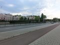
Today's hash appeared to be on a publicly accessible place in The Hague. I decided to cycle there after work. The weather was nice but very humid, and clouds were rolling in. The city centre was busy with commuters going home after work. Riding along the Raamweg (a major road connecting the city centre to the northern neighbourhoods) I watched as the distance indicator on my GPS slowly counted down. The hash was located just on the side of the road, close to the main building of the Special Court for Kosovo (one of the many special courts and tribunals located in the city). I took a few pictures and then rode home again. The clouds had become thicker and it had started to rain. There were a few flashes of lightning, but luckily they were far away and I managed to get home safely, without even getting really wet.
Photos
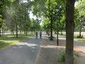
Nice sunny day in The Hague.
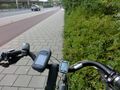
My bike right next to the spot.
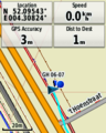
Made it!
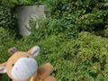
Lloyd posing for a picture.
Looking northwest.
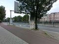
Looking southwest.


Achievements
FelixTheCat (talk) earned the Bicycle geohash achievement
|