Difference between revisions of "2017-07-13 52 1"
imported>Sourcerer (→Expedition planning) |
imported>Sourcerer m (→New expedition) |
||
| Line 19: | Line 19: | ||
Expedition 2 of 2 spanning midnight [[2017-07-12 52 1]] - [[2017-07-13 52 1]] - ETA 00:00 | Expedition 2 of 2 spanning midnight [[2017-07-12 52 1]] - [[2017-07-13 52 1]] - ETA 00:00 | ||
| − | == Expedition == | + | == Expedition - Fail == |
| − | |||
| + | There was a convenient field entrance to park. Access to the hash field was 130 metres further down the road. The entrance was blocked by a metal gate but the main problem was the crop - ripe oil seed rape. This can't easily be penetrated without a good deal of crop trampling. So this expedition failed my no-damage test and was abandoned. An alternative access route was blocked by an impressive hedge and ditch and the crop would still have been a problem. Closest approach was 64 metres at 6 minutes past midnight. | ||
== Photos == | == Photos == | ||
<gallery caption="Gallery" widths="200px" heights="200px" perrow="3"> | <gallery caption="Gallery" widths="200px" heights="200px" perrow="3"> | ||
| + | Image:2017-07-13 52 1 Sourcerer 1.jpg | Proof of Fail | ||
| + | Image:2017-07-13 52 1 Sourcerer 2.jpg | Google Earth Track | ||
</gallery> | </gallery> | ||
| Line 37: | Line 39: | ||
}} | }} | ||
| − | [[Category: | + | [[Category:Expeditions]] |
| − | |||
[[Category:Expeditions with photos]] | [[Category:Expeditions with photos]] | ||
| − | [[Category:Coordinates reached]] | + | [[Category:Coordinates not reached]] |
| − | |||
Revision as of 00:06, 13 July 2017
| Thu 13 Jul 2017 in Norwich, UK: 52.4051950, 1.6435668 geohashing.info google osm bing/os kml crox |
Location
A field east of the Sotterley Hall estate, Suffolk, UK.
Participants
Plans
Expedition 2 of 2 spanning midnight 2017-07-12 52 1 - 2017-07-13 52 1 - ETA 00:00
Expedition - Fail
There was a convenient field entrance to park. Access to the hash field was 130 metres further down the road. The entrance was blocked by a metal gate but the main problem was the crop - ripe oil seed rape. This can't easily be penetrated without a good deal of crop trampling. So this expedition failed my no-damage test and was abandoned. An alternative access route was blocked by an impressive hedge and ditch and the crop would still have been a problem. Closest approach was 64 metres at 6 minutes past midnight.
Photos
- Gallery
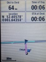
Proof of Fail
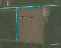
Google Earth Track


Achievements
Expeditions and Plans
| 2017-07-13 | ||
|---|---|---|
| Kassel, Germany | GeorgDerReisende | The hash lay in a corn field at Hann. Münden. |
| Norwich, United Kingdom | Sourcerer | A field east of the Sotterley Hall estate, Suffolk, UK. |
Sourcerer's Expedition Links
2017-07-12 52 1 - 2017-07-13 52 1 - 2017-07-14 52 1 - KML file download of Sourcerer's expeditions for use with Google Earth.