Difference between revisions of "2017-07-16 43 -121"
imported>Beejjorgensen (→Photos) |
imported>Jiml (Adjust result codes) |
||
| Line 1: | Line 1: | ||
| − | |||
| − | |||
| − | |||
| − | |||
| − | |||
| − | |||
| − | |||
| − | |||
{{meetup graticule | {{meetup graticule | ||
| lat=43 | | lat=43 | ||
| Line 15: | Line 7: | ||
}} | }} | ||
| − | + | ||
__NOTOC__ | __NOTOC__ | ||
== Location == | == Location == | ||
| − | + | ||
SW of Bend, OR, USA. | SW of Bend, OR, USA. | ||
== Participants == | == Participants == | ||
| − | + | ||
| − | + | * [[User:Beejjorgensen|Beejjorgensen]] | |
| − | [[User:Beejjorgensen|Beejjorgensen]] | ||
== Plans == | == Plans == | ||
| − | + | ||
Good weather this day, so the plan was to take the moto on dirt roads to head over toward the hash. | Good weather this day, so the plan was to take the moto on dirt roads to head over toward the hash. | ||
== Expedition == | == Expedition == | ||
| − | + | ||
Success! | Success! | ||
| Line 55: | Line 46: | ||
== Tracklog == | == Tracklog == | ||
| − | + | ||
[https://caltopo.com/m/68QR Beej's route] | [https://caltopo.com/m/68QR Beej's route] | ||
== Photos == | == Photos == | ||
| − | + | ||
| − | |||
| − | |||
<gallery perrow="5"> | <gallery perrow="5"> | ||
Image:2017-07-16_43_-121_wake.jpg | Near Wake Butte | Image:2017-07-16_43_-121_wake.jpg | Near Wake Butte | ||
| Line 78: | Line 67: | ||
<!-- Add any achievement ribbons you earned below, or remove this section --> | <!-- Add any achievement ribbons you earned below, or remove this section --> | ||
| − | + | * Land Geohash | |
| − | |||
| − | |||
| − | |||
| − | |||
| − | |||
| − | |||
| − | |||
| − | |||
| − | |||
| − | |||
| − | |||
[[Category:Expeditions]] | [[Category:Expeditions]] | ||
| − | |||
[[Category:Expeditions with photos]] | [[Category:Expeditions with photos]] | ||
| − | |||
| − | |||
| − | |||
| − | |||
| − | |||
[[Category:Coordinates reached]] | [[Category:Coordinates reached]] | ||
| − | |||
| − | |||
| − | |||
| − | |||
| − | |||
| − | |||
| − | |||
| − | |||
| − | |||
| − | |||
| − | |||
| − | |||
| − | |||
| − | |||
| − | |||
| − | |||
| − | |||
| − | |||
Revision as of 00:35, 28 July 2017
| Sun 16 Jul 2017 in 43,-121: 43.8192469, -121.8218976 geohashing.info google osm bing/os kml crox |
Location
SW of Bend, OR, USA.
Participants
Plans
Good weather this day, so the plan was to take the moto on dirt roads to head over toward the hash.
Expedition
Success!
The first part of the trip went past Wake Butte, which is just an awesome set of eroded rock formations.
Then stopped at the headwaters of Fall River, which is truly one of the most beautiful springs there is. The water is so clear and pure that my phone emerged undamaged after I dropped it into the depths of the river, amazingly.
On to South Twin Lake, which I hadn't visited in about 35 years.
And on north to the hash. Took a quick detour to go up a butte, and took a little spill on a sand-filled rut on the way down. Doh! No damage to bike or rider, so back on the route!
There used to be a direct road to the hashpoint back around 2000, but a bridge over Cultus River was removed and now you have to go a few km out of the way. Eventually, I found a little campsite turnout and headed cross country, on foot, into the forest. Proximity to Cultus Creek meant the mosquitoes were quite aggressive, but I braved them by dancing around with my GPS in one hand and my phone in the other, trying to get 0 m away from the hashpoint. And then I ran away, itching all over. It's making me itch again just talking about it.
After that, popped back for a look at the headwaters of Cultus River, which I almost got to, but the walk through the forest was a tough one with tons of blowdown everywhere.
And then headed back for home. First attempted dirt road had not yet been cleared of downed trees. I made an effort for a few hundred meters before giving up. (I carry a small electric chainsaw on trips like this.) I couldn't clear 4.5 km of blowdown before sunset.
But the second route went through.
Tally for the day: three geocaches, and one geohash.
Tracklog
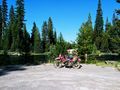
Photos
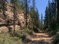
Near Wake Butte
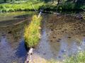
Fall River headwaters
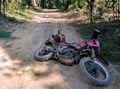
Oops!
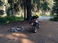
Campsite near the hash
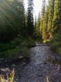
Cultus Creek
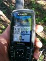
Ground Zero
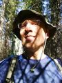
Beej!
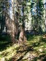
Forest around GZ
Cultus River--time to head home


Achievements
- Land Geohash