Difference between revisions of "2017-07-27 60 23"
From Geohashing
m |
|||
| Line 34: | Line 34: | ||
<!-- =============== USEFUL CATEGORIES FOLLOW ================ | <!-- =============== USEFUL CATEGORIES FOLLOW ================ | ||
Delete the next line ONLY if you have chosen the appropriate categories below. If you are unsure, don't worry. People will read your report and help you with the classification. --> | Delete the next line ONLY if you have chosen the appropriate categories below. If you are unsure, don't worry. People will read your report and help you with the classification. --> | ||
| − | |||
<!-- ==REQUEST FOR TWITTER BOT== Please leave either the New report or the Expedition planning category in as long as you work on it. This helps the twitter bot a lot with announcing the right outcome at the right moment. --> | <!-- ==REQUEST FOR TWITTER BOT== Please leave either the New report or the Expedition planning category in as long as you work on it. This helps the twitter bot a lot with announcing the right outcome at the right moment. --> | ||
Revision as of 10:23, 20 May 2020
| Thu 27 Jul 2017 in 60,23: 60.8203726, 23.0921368 geohashing.info google osm bing/os kml crox |
Location
Field in Petäjoki village, 4 km SE of Loimaa city (population 15 000). South side of river Loimijoki.
Participants
Plans
Decided to visit here on my way from Lempäälä to Turku. Grain is usually growing on fields in July, so I could not be sure to succeed or not. Satellite picture (attached below) showed that luckily the hashpoint is not located on normal grain field.
Expedition
Visit was quite easy in nice weather. I walked only 400 meters along small and dry road. After the expedition I searched nearby geocache "Petäjoen PVY" by pikkusormi at Petäjoki Pavilion, 900 m SW from hashpoint.
Photos

Grain elevators in horizon, 2.5 km NW, near Loimaa city
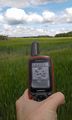
GPS coordinates
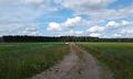
Small road near hashpoint
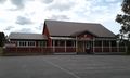
Petäjoki Pavilion, 900 m SW (geocache location)
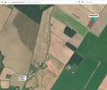
Satellite image


