2017-07-29 47 -122
| Sat 29 Jul 2017 in 47,-122: 47.6067425, -122.6376951 geohashing.info google osm bing/os kml crox |
Location
East Bremerton, by the side of NE Riddell Rd near Pine Rd NE. Street View (in a five-year-old image) shows a gravel driveway, with the hashpoint perhaps in adjacent vegetation.
Participants
Plans
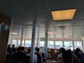
Bus to downtown Seattle. Catch the 14:35 sailing of the Rich Passage 1 fast ferry service to Bremerton, which began operation about three weeks ago as a double-speed alternative to the Washington State Ferries route. From the Bremerton dock, take Kitsap Transit bus routes 11 and 17 to a bus stop within tens of meters from the point. The bus schedules are timed perfectly for a hash o'clock visit. Return the same way, taking the 17:20 eastbound sailing of the fast ferry.
Buses: free with regional ORCA pass. Ferry: $12 round trip, which happens to be exactly the amount of cash in my wallet today.
I considered traveling the bus legs by bicycle instead, but the climb from the water to the hashpoint, in an area without much bike infrastructure, looks a little challenging. Combining bus and bike doesn't seem worth the trouble of all the loading and unloading.
Expedition
- Conveniently, the brush has been trimmed since Street View was here. GPS readings as low as 1.1ft. -- Coyotebush (talk) @47.6068,-122.6377 15:42, 29 July 2017 (PDT)
- Found a shady spot to sit and wait for hash o'clock and the return bus. -- Coyotebush (talk) @47.6063,-122.6364 15:46, 29 July 2017 (PDT)
- Ok, back to the bus stop. -- Coyotebush (talk) @47.6068,-122.6375 16:05, 29 July 2017 (PDT)
Tracklog
Photos
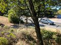
On the point.

16:00 proof @47.6068,-122.6375
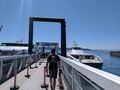
Boarding the Rich Passage 1 (right) in Seattle
Inside the ferry
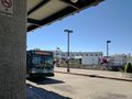
Bus picking me up from the ferry


Achievements