2017-07-29 47 -122
| Sat 29 Jul 2017 in 47,-122: 47.6067425, -122.6376951 geohashing.info google osm bing/os kml crox |
Location
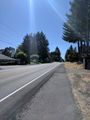
East Bremerton, by the side of NE Riddell Rd near Pine Rd NE. Street View (in a five-year-old image) shows a gravel driveway, with the hashpoint perhaps in adjacent vegetation.
Participants
Plans
Bus to downtown Seattle. Catch the 14:35 sailing of the Rich Passage 1 fast ferry service to Bremerton, which began operation about three weeks ago as a double-speed alternative to the Washington State Ferries route. From the Bremerton dock, take Kitsap Transit bus routes 11 and 17 to a bus stop within tens of meters from the point. The bus schedules are timed perfectly for a hash o'clock visit. Return the same way, taking the 17:20 eastbound sailing of the fast ferry.
Buses: free with regional ORCA pass. Ferry: $12 round trip, which happens to be exactly the amount of cash in my wallet today.
I considered traveling the bus segments by bicycle instead, but the climb from the water to the hashpoint, in an area without much bike infrastructure, looks a little challenging. Combining bus and bike doesn't seem worth the trouble of all the loading and unloading.
Expedition
I was running behind schedule after trying out one of Seattle's new dockless bike share systems around lunchtime. My first bus was running 10 minutes behind, too. Unfortunately, this meant my connection to the ferry (with a half-mile walk) would be tight and risky. But the bus got downtown quickly and a short downhill jog brought me to the ferry with a few minutes to spare. Here I realized (first bonus) that fares were not being collected during the ferry's first calendar month of service, so I kept my cash. The Rich Passage 1 is indeed quite fast and nimble, with the side effect that it's discouraged to walk around and enjoy the views as one would on the WSF boats. 30 minutes later we were in Bremerton.
A route 11 bus arrived soon after. In the timetables I discovered (second bonus) that routes 11 and 17 usually continue each others' trips, so I didn't even have to change buses at the East Bremerton Transfer Center (which is a rendezvous point in a strip mall parking lot). And then I arrived at my destination.
As anticipated, the point lay in the tall grass and trees just east of the driveway. There was no apparent activity in the homes on the west side. Rather than linger in the grass or by the side of the road, I wandered into a nearby parking lot and discovered a picnic table in the shade. I returned briefly to the driveway for the 16:00 meetup time.
- Conveniently, the brush has been trimmed since Street View was here. GPS readings as low as 1.1ft. -- Coyotebush (talk) @47.6068,-122.6377 15:42, 29 July 2017 (PDT)
- Found a shady spot to sit and wait for hash o'clock and the return bus. -- Coyotebush (talk) @47.6063,-122.6364 15:46, 29 July 2017 (PDT)
- Ok, back to the bus stop. -- Coyotebush (talk) @47.6068,-122.6375 16:05, 29 July 2017 (PDT)
The bus routes worked out the same way on the trip back to the Bremerton ferry terminal. This time I had about half an hour to make the connection to the ferry, so I wandered over to a small park squeezed between the terminal and the naval base. I watched ferries coming and going and speedboats racing around in the strait. As I boarded the Rich Passage 1 again, the Port Orchard foot ferry was departing and a WSF ferry was arriving. Back in Seattle, there were some traffic delays, perhaps related to the evening Seafair Torchlight Parade, but I made it home by about 19:00.
Photos
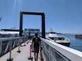
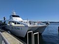
Boarding the Rich Passage 1 (right) in Seattle
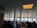
Inside the ferry
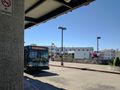
Bus picking me up from the ferry
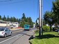
Same bus dropping me off at the hash
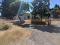
Approaching
On the point.
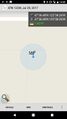
Best captured reading
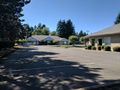
Very quiet parking lot to wait in (everything closed today)

16:00 proof @47.6068,-122.6375
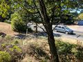
Looking back towards the hashpoint from the bus stop
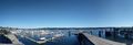
Bremerton Marina and ferry docks
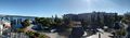
Fun park with fountains nearby
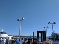
Rich Passage 1, Carlisle II (ferry to Port Orchard), Kaleetan (WSF ferry to Seattle)
It's a catamaran with a hydrofoil


Achievements
coyotebush earned the Land geohash achievement
|
coyotebush earned the Public transport geohash achievement
|
coyotebush earned the xkcd Nullaturion achievement
|