Difference between revisions of "2017-08-09 52 13"
From Geohashing
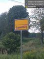
imported>CamelCase ([live picture]Definitely not Oranienburg anymore. Must have missed the road signs. [http://www.openstreetmap.org/?lat=52.76740890&lon=13.20976460&zoom=16&layers=B000FTF @52.7674,13.2098]) |
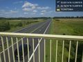
imported>CamelCase ([live picture]Some lone houses and a lot of corn fields later I am finally leaving the town. [http://www.openstreetmap.org/?lat=52.77503640&lon=13.19836860&zoom=16&layers=B000FTF @52.7750,13.1984]) |
||
| Line 45: | Line 45: | ||
Image:2017-08-09_52_13_CamelCase_1502278904402.jpg|Definitely not Oranienburg anymore. Must have missed the road signs. [http://www.openstreetmap.org/?lat=52.76740890&lon=13.20976460&zoom=16&layers=B000FTF @52.7674,13.2098] | Image:2017-08-09_52_13_CamelCase_1502278904402.jpg|Definitely not Oranienburg anymore. Must have missed the road signs. [http://www.openstreetmap.org/?lat=52.76740890&lon=13.20976460&zoom=16&layers=B000FTF @52.7674,13.2098] | ||
| + | |||
| + | Image:2017-08-09_52_13_CamelCase_1502279652412.jpg|Some lone houses and a lot of corn fields later I am finally leaving the town. [http://www.openstreetmap.org/?lat=52.77503640&lon=13.19836860&zoom=16&layers=B000FTF @52.7750,13.1984] | ||
</gallery> | </gallery> | ||
Revision as of 11:54, 9 August 2017
| Wed 9 Aug 2017 in 52,13: 52.8311615, 13.0997580 geohashing.info google osm bing/os kml crox |
Location
Participants
Plans
Expedition
Tracklog
Photos
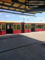
I arrived at Oranienburg station. @52.7538,13.2491
Definitely not Oranienburg anymore. Must have missed the road signs. @52.7674,13.2098
Some lone houses and a lot of corn fields later I am finally leaving the town. @52.7750,13.1984


Achievements