Difference between revisions of "2017-08-20 44 -116"
From Geohashing
imported>Simonradford (Created page with "<!-- If you did not specify these parameters in the template, please substitute appropriate values for IMAGE, LAT, LON, and DATE (YYYY-MM-DD format) Image:{{{image|IMAGE}}...") |
m |
||
| (2 intermediate revisions by 2 users not shown) | |||
| Line 40: | Line 40: | ||
--> | --> | ||
<gallery perrow="5"> | <gallery perrow="5"> | ||
| − | Image:2017-08-20_44_-116_a. | + | Image:2017-08-20_44_-116_a.png | GPS display. |
Image:2017-08-20_44_-116_b.jpg | I was on the shore. The hashpoint is in the lake. | Image:2017-08-20_44_-116_b.jpg | I was on the shore. The hashpoint is in the lake. | ||
| Line 51: | Line 51: | ||
[[Category:Expeditions]] | [[Category:Expeditions]] | ||
[[Category:Expeditions with photos]] | [[Category:Expeditions with photos]] | ||
| + | [[Category:Coordinates not reached]] | ||
| + | [[Category:Not reached - Mother Nature]] | ||
| + | {{location|US|ID|WA}} | ||
Latest revision as of 11:00, 12 September 2021
| Sun 20 Aug 2017 in 44,-116: 44.3912990, -116.8987876 geohashing.info google osm bing/os kml crox |
Location
In the Mann Creek Reservoir.
Participants
Simon; B, D, & K.
Plans
No planning, per se. We were passing by.
Expedition
Drove to the boat ramp, looked around, and declined to swim.
Photos
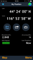
GPS display.
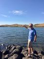
I was on the shore. The hashpoint is in the lake.

