Difference between revisions of "2017-08-20 44 -119"
imported>Frogman ([live picture]We made it!) |
m (per Renaming Proposal) |
||
| (9 intermediate revisions by 2 users not shown) | |||
| Line 1: | Line 1: | ||
| − | |||
| − | [[Image: | + | [[Image:2017-08-20_44_-119_frogman_1503266924976.jpg|thumb|left]] |
| − | |||
| − | |||
| − | |||
| − | |||
{{meetup graticule | {{meetup graticule | ||
| lat=44 | | lat=44 | ||
| Line 20: | Line 15: | ||
== Location == | == Location == | ||
<!-- where you've surveyed the hash to be --> | <!-- where you've surveyed the hash to be --> | ||
| + | |||
| + | In a heavily wooded area near a creekbed in Ochoco National Forest. | ||
== Participants == | == Participants == | ||
<!-- who attended: If you link to your wiki user name in this section, your expedition will be picked up by the various statistics generated for geohashing. You may use three tildes ~ as a shortcut to automatically insert the user signature of the account you are editing with. | <!-- who attended: If you link to your wiki user name in this section, your expedition will be picked up by the various statistics generated for geohashing. You may use three tildes ~ as a shortcut to automatically insert the user signature of the account you are editing with. | ||
--> | --> | ||
| + | * [[User:Frogman|Frogman]] ([[User talk:Frogman|talk]]) | ||
| + | * [[User:Higgs|Higgs]] | ||
| + | * Justin | ||
| + | * Jess | ||
== Plans == | == Plans == | ||
| − | + | We saw that this seemed doable, and it was on a day where nothing else was planned, so we decided to try out a geohash in this virgin graticule! During planning, we noted that the hashpoint was very close to, but not on, private property. We adjusted our route to avoid any inhabitants of the private property, if there were any. | |
== Expedition == | == Expedition == | ||
| − | + | After about an hour and a half of driving through some beautiful Central Oregon vistas, we ended up on NFS Road 12. It goes through some ranch land and into the National Forest itself. As we entered the National Forest, we saw that we were arriving in an already crowded area of the forest. It is almost certain that these were eclipse campers! It looked like an excellent place to stay. We continued on. | |
| + | Road 12 turned from asphalt to gravel as we approached the next turn. Unfortunately, the road that Google Maps told us to go on looked like it had been abandoned long ago! We were out of cell phone data range, so we decided that instead of updating our route to avoid this road, we would just hike the route that Google Maps initially suggested. | ||
| − | + | After a good length of hiking, where we briefly lost the trail a couple times, we arrived on another gravel road -- Forest Service Road 600. After a short jaunt on that, we took a brief turn into the woods. Down a steep hill, past a creek bed, and into an uncharacteristically thick part of the forest. We reached the hashpoint, took a short rest, and then retraced our steps back to the car. By then, the eclipse campsites had extended to nearby, so our drive out was a good bit more crowded than our drive in. | |
| − | |||
| − | |||
== Photos == | == Photos == | ||
| Line 55: | Line 55: | ||
Image:2017-08-20_44_-119_frogman_1503266913943.jpg|We made it! | Image:2017-08-20_44_-119_frogman_1503266913943.jpg|We made it! | ||
| + | |||
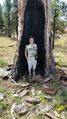
| + | Image:2017-08-20_44_-119_frogman_1503266924976.jpg|Grins. | ||
| + | |||
| + | Image:2017-08-20_44_-119_frogman_1503266940791.jpg|A wonderful view. | ||
| + | |||
| + | Image:2017-08-20_44_-119_frogman_1503266957626.jpg|View in the other direction. | ||
</gallery> | </gallery> | ||
| Line 61: | Line 67: | ||
<!-- Add any achievement ribbons you earned below, or remove this section --> | <!-- Add any achievement ribbons you earned below, or remove this section --> | ||
| − | + | {{Graticule unlocked | |
| − | |||
| − | |||
| − | + | | latitude = 44 | |
| + | | longitude = -119 | ||
| + | | date = 2017-08-20 | ||
| + | | name = [[User:Frogman|Frogman]] ([[User talk:Frogman|talk]]), [[User:Higgs|Higgs]], Justin, and Jesse | ||
| − | + | }} | |
| − | + | ||
| − | [[ | + | {{drag-along |
| − | + | ||
| + | | latitude = 44 | ||
| + | | longitude = -119 | ||
| + | | date = 2017-08-20 | ||
| + | | partner = Justin and Jesse | ||
| + | | name = [[User:Frogman|Frogman]] ([[User talk:Frogman|talk]]) and [[User:Higgs|Higgs]] | ||
| − | + | }} | |
| − | |||
[[Category:Expeditions]] | [[Category:Expeditions]] | ||
| − | |||
[[Category:Expeditions with photos]] | [[Category:Expeditions with photos]] | ||
| − | |||
| − | |||
| − | |||
| − | |||
[[Category:Coordinates reached]] | [[Category:Coordinates reached]] | ||
| − | + | {{location|US|OR|WE}} | |
| − | |||
| − | |||
| − | |||
| − | |||
| − | |||
| − | |||
| − | |||
| − | |||
| − | |||
| − | |||
| − | |||
| − | |||
| − | |||
| − | |||
| − | |||
| − | |||
| − | |||
Latest revision as of 04:56, 20 March 2024

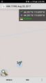
| Sun 20 Aug 2017 in 44,-119: 44.3912990, -119.8987876 geohashing.info google osm bing/os kml crox |
Location
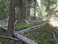
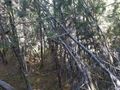
In a heavily wooded area near a creekbed in Ochoco National Forest.
Participants
Plans
We saw that this seemed doable, and it was on a day where nothing else was planned, so we decided to try out a geohash in this virgin graticule! During planning, we noted that the hashpoint was very close to, but not on, private property. We adjusted our route to avoid any inhabitants of the private property, if there were any.
Expedition
After about an hour and a half of driving through some beautiful Central Oregon vistas, we ended up on NFS Road 12. It goes through some ranch land and into the National Forest itself. As we entered the National Forest, we saw that we were arriving in an already crowded area of the forest. It is almost certain that these were eclipse campers! It looked like an excellent place to stay. We continued on.
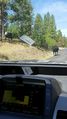
Road 12 turned from asphalt to gravel as we approached the next turn. Unfortunately, the road that Google Maps told us to go on looked like it had been abandoned long ago! We were out of cell phone data range, so we decided that instead of updating our route to avoid this road, we would just hike the route that Google Maps initially suggested.
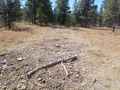
After a good length of hiking, where we briefly lost the trail a couple times, we arrived on another gravel road -- Forest Service Road 600. After a short jaunt on that, we took a brief turn into the woods. Down a steep hill, past a creek bed, and into an uncharacteristically thick part of the forest. We reached the hashpoint, took a short rest, and then retraced our steps back to the car. By then, the eclipse campsites had extended to nearby, so our drive out was a good bit more crowded than our drive in.
Photos
This road is not as navigable as Google would claim.
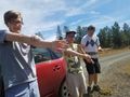
Getting ready for a hike!
Cows!
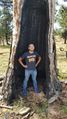
Standing in a tree!
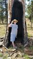
We all had to stand in it.
Geohasher number 3.
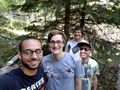
We made it!
Grins.
A wonderful view.
View in the other direction.


Achievements
Frogman (talk), Higgs, Justin, and Jesse earned the Graticule Unlocked Achievement
|
Frogman (talk) and Higgs earned the Drag-along achievement
|