Difference between revisions of "2017-09-04 51 9"
From Geohashing
imported>GeorgDerReisende (new report) |
imported>GeorgDerReisende (expedition report for Hess. Lichtenau) |
||
| Line 1: | Line 1: | ||
| − | |||
| − | |||
| − | |||
| − | |||
| − | |||
| − | |||
| − | |||
| − | |||
| − | |||
| − | |||
{{meetup graticule | {{meetup graticule | ||
| lat=51 | | lat=51 | ||
| Line 19: | Line 9: | ||
== Location == | == Location == | ||
| − | + | ||
| + | The hash lay on a meadow in front of former barracks in Hessisch Lichtenau. | ||
== Participants == | == Participants == | ||
| − | + | ||
| − | + | [[User:GeorgDerReisende|GeorgDerReisende]] | |
== Plans == | == Plans == | ||
| − | + | ||
| + | Hitchhiking. | ||
== Expedition == | == Expedition == | ||
| − | |||
| − | + | I left home at 13:40 and started to hitchhike at 14:15. Within one minute a car stopped and I got a lift just to the place of hash. I just had to go onto the meadow. | |
| − | |||
== Photos == | == Photos == | ||
| − | |||
| − | |||
| − | |||
<gallery perrow="5"> | <gallery perrow="5"> | ||
| + | Image:2017-09-04 51 9 GeorgDerReisende 1060.jpg | entrance to hash | ||
| + | Image:2017-09-04 51 9 GeorgDerReisende 1063.jpg | 18 meters to hash | ||
| + | Image:2017-09-04 51 9 GeorgDerReisende 1064.jpg | arrived | ||
| + | Image:2017-09-04 51 9 GeorgDerReisende 1065.jpg | the north | ||
| + | Image:2017-09-04 51 9 GeorgDerReisende 1066.jpg | the east | ||
| + | Image:2017-09-04 51 9 GeorgDerReisende 1067.jpg | the south | ||
| + | Image:2017-09-04 51 9 GeorgDerReisende 1068.jpg | the west | ||
| + | Image:2017-09-04 51 9 GeorgDerReisende 1069.jpg | the geohasher | ||
| + | Image:2017-09-04 51 9 GeorgDerReisende 1071.jpg | the place of delivery | ||
| + | Image:2017-09-04 51 9 GeorgDerReisende 1073.jpg | the street beside the hash | ||
</gallery> | </gallery> | ||
| Line 45: | Line 42: | ||
<!-- Add any achievement ribbons you earned below, or remove this section --> | <!-- Add any achievement ribbons you earned below, or remove this section --> | ||
| − | + | {{Thumbs Up | latitude = 51 | longitude = 9 | date = 2017-09-04 | name = GeorgDerReisende }} | |
| − | |||
| − | |||
| − | + | [[Category:Expeditions]] | |
| − | + | [[Category:Expeditions with photos]] | |
| − | |||
| − | |||
| − | |||
| − | |||
| − | |||
| − | |||
| − | |||
| − | |||
| − | |||
| − | |||
| − | |||
| − | |||
| − | |||
| − | |||
[[Category:Coordinates reached]] | [[Category:Coordinates reached]] | ||
| − | |||
| − | |||
| − | |||
| − | |||
| − | |||
| − | |||
| − | |||
| − | |||
| − | |||
| − | |||
| − | |||
| − | |||
| − | |||
| − | |||
| − | |||
| − | |||
| − | |||
| − | |||
Revision as of 21:35, 4 September 2017
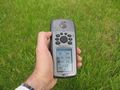
| Mon 4 Sep 2017 in 51,9: 51.1937160, 9.7363380 geohashing.info google osm bing/os kml crox |
Location
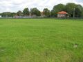
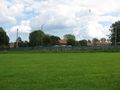
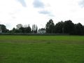
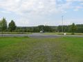
The hash lay on a meadow in front of former barracks in Hessisch Lichtenau.
Participants
Plans
Hitchhiking.
Expedition
I left home at 13:40 and started to hitchhike at 14:15. Within one minute a car stopped and I got a lift just to the place of hash. I just had to go onto the meadow.
Photos
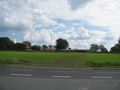
entrance to hash
18 meters to hash
arrived
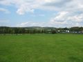
the north
the east
the south
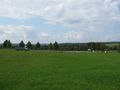
the west
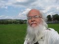
the geohasher
the place of delivery
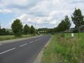
the street beside the hash


Achievements
GeorgDerReisende earned the Thumbs Up Geohash Achievement
|