Difference between revisions of "2017-10-15 49 8"
imported>DODO (→Tracklog) |
imported>FippeBot m (Location) |
||
| (2 intermediate revisions by one other user not shown) | |||
| Line 43: | Line 43: | ||
Image:2012-##-## ## ## Alpha.jpg | Witty Comment | Image:2012-##-## ## ## Alpha.jpg | Witty Comment | ||
--> | --> | ||
| − | <gallery perrow=" | + | <gallery perrow="4"> |
| + | Image:2017-10-15_49_8-3.jpg|proof of transport | ||
| + | Image:2017-10-15_49_8-7.jpg|45 m to go (35 along the field) | ||
| + | Image:2017-10-15_49_8-1.png|proof | ||
| + | Image:2017-10-15_49_8-4.jpg|happy hasher | ||
| + | Image:2017-10-15_49_8-6.jpg|view to the north | ||
| + | Image:2017-10-15_49_8-5.jpg|and the west | ||
| + | Image:2017-10-15_49_8-2.jpg|gratification | ||
</gallery> | </gallery> | ||
| Line 50: | Line 57: | ||
<!-- Add any achievement ribbons you earned below, or remove this section --> | <!-- Add any achievement ribbons you earned below, or remove this section --> | ||
| − | + | {{land geohash | |
| − | + | | latitude = 49 | |
| − | + | | longitude = 8 | |
| + | | date = 2017-10-15 | ||
| + | | name = DODO | ||
| + | }} | ||
| − | + | {{bicycle geohash | |
| + | | latitude = 49 | ||
| + | | longitude = 8 | ||
| + | | date = 2017-10-15 | ||
| + | | name = DODO | ||
| + | | distance = 15 KM | ||
| + | }} | ||
| − | |||
| − | |||
| − | |||
| − | |||
| − | |||
| − | |||
| − | |||
[[Category:Expeditions]] | [[Category:Expeditions]] | ||
| − | |||
| − | |||
| − | |||
| − | |||
| − | |||
| − | |||
| − | |||
[[Category:Coordinates reached]] | [[Category:Coordinates reached]] | ||
| − | + | {{location|DE|RP|RP}} | |
| − | |||
| − | |||
| − | |||
| − | |||
| − | |||
| − | |||
| − | |||
| − | |||
| − | |||
| − | |||
| − | |||
| − | |||
| − | |||
| − | |||
| − | |||
| − | |||
| − | |||
Latest revision as of 03:03, 16 August 2019
| Sun 15 Oct 2017 in 49,8: 49.2729565, 8.3923632 geohashing.info google osm bing/os kml crox |
Location
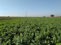
40m into a cabbage-field between Römerberg and Mechtersheim.
Participants
Plans
To close not to go. Find a free hour and go there by bike (to much work for a walking-approach).
Expedition
Well, almost as planned: took my bike at half past twelve. Reached hash-area 20 minutes later. I found out that I had to go into a cabbage field, locked the bike and walked between two fields until the hash was 15 m away. From here I had to enter the plants, but they were quite big and had plenty of space between them, so I could enter the field without seriously harm any of them. Took some pictures and hurried back to my bike again. On the way back I bought some cake for celebration.
Tracklog
Photos
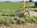
proof of transport
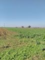
45 m to go (35 along the field)
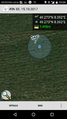
proof
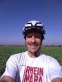
happy hasher
view to the north
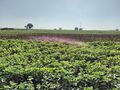
and the west
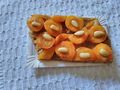
gratification


Achievements
DODO earned the Land geohash achievement
|
DODO earned the Bicycle geohash achievement
|