Difference between revisions of "2017-10-27 48 11"
From Geohashing
imported>Solli ([live] Been there, done that, details follow.) |
imported>Solli |
||
| Line 1: | Line 1: | ||
| − | |||
| − | |||
| − | |||
| − | |||
| − | |||
| − | |||
| − | |||
| − | |||
| − | |||
| − | |||
{{meetup graticule | {{meetup graticule | ||
| lat=48 | | lat=48 | ||
| Line 15: | Line 5: | ||
}} | }} | ||
| − | |||
__NOTOC__ | __NOTOC__ | ||
== Location == | == Location == | ||
| − | + | On a field near Wolnzach, between the motorway and a hops plantation | |
== Participants == | == Participants == | ||
| − | + | * [[Users:Solli|Solli]] | |
| − | |||
== Plans == | == Plans == | ||
| − | + | Nice weather for an expedition! Make a small detour after work and drive on the gravel path almost to the hashpoint. | |
== Expedition == | == Expedition == | ||
| − | + | Wolnzach is in the Hallertau, an area world-famous for its hops plantations. As it turned out the hashpoint was between one of those and the Autobahn. The hops are already harvested at this time of the year, but the view in the evening sun was fantastic anyway. | |
| − | |||
| − | |||
| − | |||
| − | |||
| − | |||
== Photos == | == Photos == | ||
| − | |||
| − | |||
| − | |||
<gallery perrow="5"> | <gallery perrow="5"> | ||
| + | Image:2017-10-27 48 11 Solli 01.png | Proof | ||
| + | Image:2017-10-27 48 11 Solli 02.jpg | Stupid Grin (tm) | ||
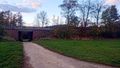
| + | Image:2017-10-27 48 11 Solli 03.jpg | View from the hashpoint to the motorway | ||
| + | Image:2017-10-27 48 11 Solli 04.jpg | View from the hashpoint to the hops plantations | ||
| + | Image:2017-10-27 48 11 Solli 05.jpg | Another shot of the hops plantations | ||
| + | Image:2017-10-27 48 11 Solli 06.jpg | The motorway | ||
</gallery> | </gallery> | ||
== Achievements == | == Achievements == | ||
{{#vardefine:ribbonwidth|800px}} | {{#vardefine:ribbonwidth|800px}} | ||
| − | + | {{land geohash | |
| + | | latitude = 48 | ||
| + | | longitude = 11 | ||
| + | | date = 2017-10-27 | ||
| + | | name = Solli | ||
| + | }} | ||
| − | |||
| − | |||
| − | |||
| − | |||
| − | |||
| − | |||
| − | |||
| − | |||
| − | |||
| − | |||
| − | |||
| − | |||
| − | |||
| − | |||
[[Category:Expeditions]] | [[Category:Expeditions]] | ||
| − | |||
[[Category:Expeditions with photos]] | [[Category:Expeditions with photos]] | ||
| − | |||
| − | |||
| − | |||
| − | |||
| − | |||
[[Category:Coordinates reached]] | [[Category:Coordinates reached]] | ||
| − | |||
| − | |||
| − | |||
| − | |||
| − | |||
| − | |||
| − | |||
| − | |||
| − | |||
| − | |||
| − | |||
| − | |||
| − | |||
| − | |||
| − | |||
| − | |||
| − | |||
| − | |||
Revision as of 11:10, 6 November 2017
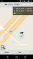
| Fri 27 Oct 2017 in 48,11: 48.6033477, 11.6493708 geohashing.info google osm bing/os kml crox |
Location
On a field near Wolnzach, between the motorway and a hops plantation
Participants
Plans
Nice weather for an expedition! Make a small detour after work and drive on the gravel path almost to the hashpoint.
Expedition
Wolnzach is in the Hallertau, an area world-famous for its hops plantations. As it turned out the hashpoint was between one of those and the Autobahn. The hops are already harvested at this time of the year, but the view in the evening sun was fantastic anyway.
Photos
Proof

Stupid Grin (tm)
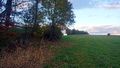
View from the hashpoint to the motorway
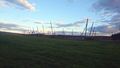
View from the hashpoint to the hops plantations
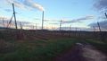
Another shot of the hops plantations
The motorway


Achievements
Solli earned the Land geohash achievement
|