Difference between revisions of "2017-10-31 51 9"
From Geohashing
m |
(→Photos) |
||
| Line 28: | Line 28: | ||
== Photos == | == Photos == | ||
| − | |||
| − | |||
| − | |||
| − | + | <gallery> | |
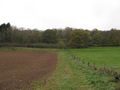
| + | File:2017-10-31 51 9 GeorgDerReisende 4651.jpg | view from the bridge to the hash area | ||
| + | File:2017-10-31 51 9 GeorgDerReisende 4673.jpg | down there is the hash | ||
| + | File:2017-10-31 51 9 GeorgDerReisende 4674.jpg | proof | ||
| + | File:2017-10-31 51 9 GeorgDerReisende 4678.jpg | not reached | ||
| + | File:2017-10-31 51 9 GeorgDerReisende 4703.jpg | looking from the valley | ||
| + | </gallery> | ||
[[Category:Expeditions]] | [[Category:Expeditions]] | ||
Latest revision as of 12:34, 27 March 2022
| Tue 31 Oct 2017 in 51,9: 51.1849504, 9.8194132 geohashing.info google osm bing/os kml crox |
Location
The hash lay beyond a forest way at Hessisch Lichtenau-Küchen.
Participants
Plans
Tram, hitchhiking, walking.
Expedition
I left home at 12:15 and started to hitchhike at 13:00. After some minutes a car stopped and I got a lift to Küchen. There I walked to the hash, but it was about 25 meters steep beyond the way and I couldn't find a way around.
Tracklog
Photos
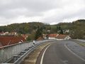
view from the bridge to the hash area
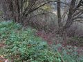
down there is the hash
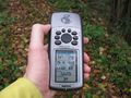
proof
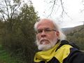
not reached
looking from the valley


