Difference between revisions of "2017-12-17 50 19"
imported>Zyxist (Created page with "{{subst:Expedition |lat = 50 |lon = 19 |date = 2017-12-17 }}") |
imported>Zyxist (+story of the expedition) |
||
| Line 19: | Line 19: | ||
== Location == | == Location == | ||
| − | + | ''Lasy Tynieckie'' forest at the western suburbs of Krakow (about 13 kilometers from the city center). The point is located just next to the path, at the entrance to the forest, near Wielogórska street. | |
== Participants == | == Participants == | ||
| − | + | [[User:Zyxist|Zyxist]] alone | |
| − | |||
== Plans == | == Plans == | ||
| − | + | I discovered geohashing just the day before and noticed that the next point is very close to me. | |
== Expedition == | == Expedition == | ||
| − | + | The geohash point was within the city administrative boundaries, so I decided to walk there from Wawel Castle (note: I also walked to Wawel Castle itself from home). Because Krakow is full of historic buildings and monuments, I also decided to look at the past and visit as many retrohashes, as possible :). Eventually I found 6 retrohashes that were located along my way. Actually, there were at least three more, but they were located at the private properties. | |
| + | |||
| + | I started my walk at 10:00 AM, next to Wawel Castle. There was a huge snowfall in the morning and I was worried that it would not be possible to make photos, but fortunately the snow stopped falling at the right time! The first retrohash '''1981-01-25''' was located nearby, at the bank of Vistula river, very close to the Dzok the Dog monument. I made a couple of photos there and I crossed the river. The next retrohash ('''1998-02-25''') was in the middle of a small street. It used to be a part of a village Dębniki that was later included into the growing city and transformed into one of central districts, with many modern buildings. However, an old chapel just next to the retrohash survived until now. | ||
| + | |||
| + | After crossing another street, the urban area suddenly ends. There are some houses, and then - a forest. The citizens enjoy walking there. I turned left into another street, and followed the houses. Behind a monastery, there was yet another retrohash, '''1980-11-23''', and a couple hundred of meters later, along the same street - one more ('''1983-02-02'''). Later, I entered the university campus and followed a long, straight promenade. This part of the city has been rapidly developing in the recent years, so the modern buildings can be found just next to grasslands and even bogs :). The streets can suddenly end, and become small paths. In such a landscape, I found the fifth retrohash: '''1973-10-09'''. | ||
| + | |||
| + | I reached the city suburbs. The weather got much better. There was a lot of sun, and I could not see a single cloud at the sky. It was a really nice day for a walk. I crossed the motorway - behind it, the destination forest starts. It grows on a series of hills, so I had to climb a bit, but it wasn't too hard. Suddenly, an obstacle - the sign ''Private property, no trespassing''. ''`Oh sheet`'', I said, ''`in the middle of a forest?`'' I looked at the sign. There was a handwritten complaint that someone had taken over the ground illegally, and then I realized that the path does not even enter it, but goes along the border. The pass was free - what a relief! | ||
| + | |||
| + | I found the last retrohash, '''1967-06-08''' somewhere in the forest. A couple of hundreds of meters farther, there was my goal. This time, the ''current'' geohash. It lied just next to the path, close to the forest entrance. My GPS got a bit weird, and I had problems locating it correctly, but after several trials everything stabilized and I was pretty sure I was there. It was a nice, sunday trip. | ||
| + | |||
| + | To sum up, I visited not only the goal for this day, but also 6 retrohashes along my trail... and made a some nice photos, too! | ||
== Tracklog == | == Tracklog == | ||
| Line 35: | Line 44: | ||
== Photos == | == Photos == | ||
| − | |||
| − | |||
| − | |||
<gallery perrow="5"> | <gallery perrow="5"> | ||
| + | Image:2017-12-17-50-19-wawel.jpg|The expedition started at Wawel Castle, the seat of Polish kings | ||
| + | Image:2017-12-17-50-19-first-retrohash.jpg|First of six retrohashes reached (1981-01-25) | ||
| + | Image:2017-12-17-50-19-second-retrohash.jpg|Second retrohash reached (1998-02-25) | ||
| + | Image:2017-12-17-50-19-third-retrohash.jpg|Third retrohash reached (1980-11-23) | ||
| + | Image:2017-12-17-50-19-third-retrohash-scenery.jpg|The view of a monastery from the retrohash point | ||
| + | Image:2017-12-17-50-19-fourth-retrohash.jpg|Fourth retrohash (1983-02-02) | ||
| + | Image:2017-12-17-50-19-fourth-retrohash-scenery.jpg|Scenery? Some bushes, and a road. | ||
| + | Image:2017-12-17-50-19-fifth-retrohash.jpg|Fifth retrohash (1973-10-09) | ||
| + | Image:2017-12-17-50-19-fifth-retrohash-panorama.jpg|Panorama of Ruczaj district | ||
| + | Image:2017-12-17-50-19-reaching-forest.jpg|Reaching the destination forest... | ||
| + | Image:2017-12-17-50-19-sixth-retrohash.jpg|And... sixth retrohash in the forest! (1967-06-08) | ||
| + | Image:2017-12-17-50-19-proof-goal.jpg|Finish! Reached the goal. | ||
| + | Image:2017-12-17-50-19-hash-scenery.jpg|Scenery at the hashpoint. | ||
| + | |||
</gallery> | </gallery> | ||
== Achievements == | == Achievements == | ||
{{#vardefine:ribbonwidth|800px}} | {{#vardefine:ribbonwidth|800px}} | ||
| − | + | {{Walk geohash | |
| + | | latitude = 50 | ||
| + | | longitude = 19 | ||
| + | | date = 2017-12-17 | ||
| + | | name = [[User:Zyxist|Zyxist]] | ||
| + | | distance = 14.5 km | ||
| + | }} | ||
| − | |||
| − | |||
| − | |||
| − | + | [[Category:Expeditions with photos]] | |
| − | |||
| − | |||
| − | |||
| − | [[Category: | ||
| − | |||
| − | |||
| − | |||
| − | |||
| − | |||
[[Category:Expeditions]] | [[Category:Expeditions]] | ||
| − | |||
| − | |||
| − | |||
| − | |||
| − | |||
| − | |||
| − | |||
[[Category:Coordinates reached]] | [[Category:Coordinates reached]] | ||
| − | |||
| − | |||
| − | |||
| − | |||
| − | |||
| − | |||
| − | |||
| − | |||
| − | |||
| − | |||
| − | |||
| − | |||
| − | |||
| − | |||
| − | |||
| − | |||
| − | |||
| − | |||
Revision as of 21:55, 17 December 2017
| Sun 17 Dec 2017 in 50,19: 50.0008385, 19.8250286 geohashing.info google osm bing/os kml crox |
Location
Lasy Tynieckie forest at the western suburbs of Krakow (about 13 kilometers from the city center). The point is located just next to the path, at the entrance to the forest, near Wielogórska street.
Participants
Zyxist alone
Plans
I discovered geohashing just the day before and noticed that the next point is very close to me.
Expedition
The geohash point was within the city administrative boundaries, so I decided to walk there from Wawel Castle (note: I also walked to Wawel Castle itself from home). Because Krakow is full of historic buildings and monuments, I also decided to look at the past and visit as many retrohashes, as possible :). Eventually I found 6 retrohashes that were located along my way. Actually, there were at least three more, but they were located at the private properties.
I started my walk at 10:00 AM, next to Wawel Castle. There was a huge snowfall in the morning and I was worried that it would not be possible to make photos, but fortunately the snow stopped falling at the right time! The first retrohash 1981-01-25 was located nearby, at the bank of Vistula river, very close to the Dzok the Dog monument. I made a couple of photos there and I crossed the river. The next retrohash (1998-02-25) was in the middle of a small street. It used to be a part of a village Dębniki that was later included into the growing city and transformed into one of central districts, with many modern buildings. However, an old chapel just next to the retrohash survived until now.
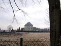
After crossing another street, the urban area suddenly ends. There are some houses, and then - a forest. The citizens enjoy walking there. I turned left into another street, and followed the houses. Behind a monastery, there was yet another retrohash, 1980-11-23, and a couple hundred of meters later, along the same street - one more (1983-02-02). Later, I entered the university campus and followed a long, straight promenade. This part of the city has been rapidly developing in the recent years, so the modern buildings can be found just next to grasslands and even bogs :). The streets can suddenly end, and become small paths. In such a landscape, I found the fifth retrohash: 1973-10-09.
I reached the city suburbs. The weather got much better. There was a lot of sun, and I could not see a single cloud at the sky. It was a really nice day for a walk. I crossed the motorway - behind it, the destination forest starts. It grows on a series of hills, so I had to climb a bit, but it wasn't too hard. Suddenly, an obstacle - the sign Private property, no trespassing. `Oh sheet`, I said, `in the middle of a forest?` I looked at the sign. There was a handwritten complaint that someone had taken over the ground illegally, and then I realized that the path does not even enter it, but goes along the border. The pass was free - what a relief!
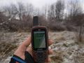
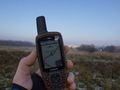
I found the last retrohash, 1967-06-08 somewhere in the forest. A couple of hundreds of meters farther, there was my goal. This time, the current geohash. It lied just next to the path, close to the forest entrance. My GPS got a bit weird, and I had problems locating it correctly, but after several trials everything stabilized and I was pretty sure I was there. It was a nice, sunday trip.
To sum up, I visited not only the goal for this day, but also 6 retrohashes along my trail... and made a some nice photos, too!
Tracklog
Photos
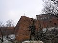
The expedition started at Wawel Castle, the seat of Polish kings
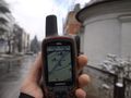
First of six retrohashes reached (1981-01-25)
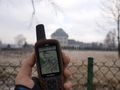
Second retrohash reached (1998-02-25)
Third retrohash reached (1980-11-23)
The view of a monastery from the retrohash point
Fourth retrohash (1983-02-02)
Scenery? Some bushes, and a road.
Fifth retrohash (1973-10-09)
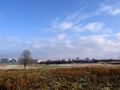
Panorama of Ruczaj district
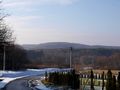
Reaching the destination forest...
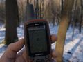
And... sixth retrohash in the forest! (1967-06-08)
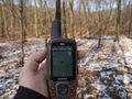
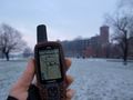
Finish! Reached the goal.
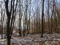
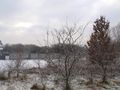
Scenery at the hashpoint.


Achievements
Zyxist earned the Walk geohash Achievement
|