Difference between revisions of "2017-12-20 42 -73"
imported>Ipswichb m |
m |
||
| (4 intermediate revisions by 3 users not shown) | |||
| Line 21: | Line 21: | ||
<gallery perrow="2"> | <gallery perrow="2"> | ||
Image:darkindustriallot.jpg | Potato quality photo of the industrial lot as seen from the hashpoint. | Image:darkindustriallot.jpg | Potato quality photo of the industrial lot as seen from the hashpoint. | ||
| − | Image:12-20-17success. | + | Image:12-20-17success.png | Proof |
| + | </gallery> | ||
[[Category:Expeditions]] | [[Category:Expeditions]] | ||
| − | [[Category:Expeditions with | + | [[Category:Coordinates reached]] |
| + | [[Category:Expeditions with photos]] | ||
| + | {{location|US|NY|SN}} | ||
Latest revision as of 11:01, 12 September 2021
| Wed 20 Dec 2017 in 42,-73: 42.8397452, -73.9755348 geohashing.info google osm bing/os kml crox |
Contents
Location
On the border of an industrial park near a railroad in Schenectady.
Participants
Expedition
I was in the middle of a fourteen-hour drive and figured I would grab a geohash along my way. This one wasn't that far off my route at all, so I thought I'd give it a try. I arrived in Schenectady around 5:30, by which time it was getting to be dark. This wasn't much of a problem because the hashpoint was so close to the road, and I parked nearby in the parking lot of a mortgage company. To get to the hash, I simply walked along the side of the building, crossed the railroad tracks, scrambled over an embankment, walked about fifteen more meters on the dirt road and the other side and there I was!
It was too dark to take any good pictures, but what I have is attached along with a screenshot as proof of the expedition's success. Not the most thrilling or glamorous expedition, but I'm glad to bring this graticule its first action in eight years!
Afterwards, I drove back to the highway and through the little town of Scotia and continued on my way. It was a nice break in the monotony of driving.
Photos

Potato quality photo of the industrial lot as seen from the hashpoint.
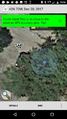
Proof

