Difference between revisions of "2018-01-28 47 -122"
From Geohashing
imported>Thomcat ([live picture]Use path [http://www.openstreetmap.org/?lat=47.80650730&lon=-122.28675290&zoom=16&layers=B000FTF @47.8065,-122.2868]) |
imported>Thomcat ([live picture]hasher [http://www.openstreetmap.org/?lat=47.80572730&lon=-122.28666370&zoom=16&layers=B000FTF @47.8057,-122.2867]) |
||
| Line 40: | Line 40: | ||
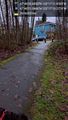
Image:2018-01-28_47_-122_thomcat_1517155439505.jpg|Use path [http://www.openstreetmap.org/?lat=47.80650730&lon=-122.28675290&zoom=16&layers=B000FTF @47.8065,-122.2868] | Image:2018-01-28_47_-122_thomcat_1517155439505.jpg|Use path [http://www.openstreetmap.org/?lat=47.80650730&lon=-122.28675290&zoom=16&layers=B000FTF @47.8065,-122.2868] | ||
| + | |||
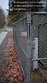
| + | Image:2018-01-28_47_-122_thomcat_1517155750235.jpg|hasher [http://www.openstreetmap.org/?lat=47.80572730&lon=-122.28666370&zoom=16&layers=B000FTF @47.8057,-122.2867] | ||
</gallery> | </gallery> | ||
Revision as of 16:09, 28 January 2018
| Sun 28 Jan 2018 in Seattle: 47.8057487, -122.2866554 geohashing.info google osm bing/os kml crox |
Location
A residential street in Mountlake Terrace, quite close to the High School.
Participants
Plans
Dawn visit, perhaps? No particular plans.
Expedition
Tracklog
Photos

Dawn in 5 min, but not under these clouds @47.7089,-122.3335

Parked @47.8058,-122.2867
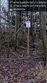
Path to geohashpoint @47.8059,-122.2870
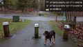
Hashdog @47.8064,-122.2872
They indeed @47.8068,-122.2871
Use path @47.8065,-122.2868

hasher @47.8057,-122.2867


Achievements