Difference between revisions of "2018-02-25 40 -3"
imported>S21 (Created page with "{{subst:Expedition |lat = 40 |lon = -3 |date = 2018-02-25 }}") |
imported>S21 |
||
| Line 19: | Line 19: | ||
== Location == | == Location == | ||
| − | + | Torremocha de Jarama, a rural village in northeastern Madrid, Spain. | |
== Participants == | == Participants == | ||
| − | + | [[user:s21|s21]] | |
| − | |||
== Plans == | == Plans == | ||
| − | < | + | According to the intial inspection, the hashpoint was in a crop field. <br /> Given that cereal is usually the crop in most of [[40,-3]], there was a possibility that whatever it was, it was still growing and weak. I didn't want to <s>mess with any local farmer</s> ruin any crop, especially given the proximity to my own village, so there was a possibility of a massive failure. |
| + | |||
| + | |||
== Expedition == | == Expedition == | ||
| − | < | + | I set sail to the hashpoint, dragging girlfriend and hashcot along! |
| + | |||
| + | The road was quite familiar to me, the route was quite beautiful as usual. <br /> The hashpoint was in the expected crop field, which was divided into 2 parts: one set as a fallow land and another actually on its way for the harvest on May. The hashpoint was in the fallow part :D. | ||
| + | |||
| + | I parked by the entrance of what seemed like a state-run center for the problematic youth. Great place to wander around a field with a GPS-enabled device in hand! | ||
| + | |||
| + | Even though my only tool was an android phone, I checked by the notable features around that the central blue dot was indeed remarkably reliable, even though it moved randomly sometimes. | ||
| + | |||
| + | My first successful geohash! :) | ||
| − | |||
| − | |||
== Photos == | == Photos == | ||
| Line 39: | Line 46: | ||
--> | --> | ||
<gallery perrow="5"> | <gallery perrow="5"> | ||
| + | Image:2018-02-15 40 -3 spot.jpg | Acceptable as barely a proof? | ||
| + | Image:2018-02-15 40 -3 surroundings.jpg | Barely acceptable proof with surroundings. | ||
| + | Image:2018-02-15 40 -3 Josh!.jpg | Barely acceptable proof with JOSH! I think he still didn't quite get the thing. | ||
| + | Image:2018-02-15 40 -3 in3rdperson.jpg | Can you spot me in there? | ||
</gallery> | </gallery> | ||
== Achievements == | == Achievements == | ||
| + | {{land geohash | ||
| + | |||
| + | | latitude = 40 | ||
| + | | longitude = -3 | ||
| + | | date = 2018-02-25 | ||
| + | | name = s21 | ||
| + | |||
| + | }} | ||
{{#vardefine:ribbonwidth|800px}} | {{#vardefine:ribbonwidth|800px}} | ||
<!-- Add any achievement ribbons you earned below, or remove this section --> | <!-- Add any achievement ribbons you earned below, or remove this section --> | ||
| + | {{drag-along | ||
| + | |||
| + | | latitude = 40 | ||
| + | | longitude = -3 | ||
| + | | date = 2018-02-25 | ||
| + | | partner = Elena | ||
| + | | name = s21 | ||
| + | |||
| + | }} | ||
<!-- =============== USEFUL CATEGORIES FOLLOW ================ | <!-- =============== USEFUL CATEGORIES FOLLOW ================ | ||
Delete the next line ONLY if you have chosen the appropriate categories below. If you are unsure, don't worry. People will read your report and help you with the classification. --> | Delete the next line ONLY if you have chosen the appropriate categories below. If you are unsure, don't worry. People will read your report and help you with the classification. --> | ||
| − | + | ||
<!-- ==REQUEST FOR TWITTER BOT== Please leave either the New report or the Expedition planning category in as long as you work on it. This helps the twitter bot a lot with announcing the right outcome at the right moment. --> | <!-- ==REQUEST FOR TWITTER BOT== Please leave either the New report or the Expedition planning category in as long as you work on it. This helps the twitter bot a lot with announcing the right outcome at the right moment. --> | ||
| − | |||
| − | |||
| − | |||
| − | |||
| − | |||
| − | + | ||
[[Category:Expeditions]] | [[Category:Expeditions]] | ||
| − | |||
[[Category:Expeditions with photos]] | [[Category:Expeditions with photos]] | ||
| − | |||
| − | |||
| − | |||
| − | |||
[[Category:Coordinates reached]] | [[Category:Coordinates reached]] | ||
| − | |||
| − | |||
| − | |||
| − | |||
| − | |||
| − | |||
| − | |||
| − | |||
| − | |||
| − | |||
| − | |||
| − | |||
| − | |||
| − | |||
| − | |||
| − | |||
| − | |||
| − | |||
Revision as of 22:39, 26 February 2018
| Sun 25 Feb 2018 in 40,-3: 40.8391693, -3.4881392 geohashing.info google osm bing/os kml crox |
Location
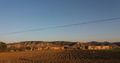
Torremocha de Jarama, a rural village in northeastern Madrid, Spain.
Participants
Plans
According to the intial inspection, the hashpoint was in a crop field.
Given that cereal is usually the crop in most of 40,-3, there was a possibility that whatever it was, it was still growing and weak. I didn't want to mess with any local farmer ruin any crop, especially given the proximity to my own village, so there was a possibility of a massive failure.
Expedition
I set sail to the hashpoint, dragging girlfriend and hashcot along!
The road was quite familiar to me, the route was quite beautiful as usual.
The hashpoint was in the expected crop field, which was divided into 2 parts: one set as a fallow land and another actually on its way for the harvest on May. The hashpoint was in the fallow part :D.
I parked by the entrance of what seemed like a state-run center for the problematic youth. Great place to wander around a field with a GPS-enabled device in hand!
Even though my only tool was an android phone, I checked by the notable features around that the central blue dot was indeed remarkably reliable, even though it moved randomly sometimes.
My first successful geohash! :)
Photos
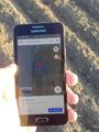
Acceptable as barely a proof?
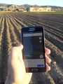
Barely acceptable proof with surroundings.
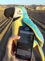
Barely acceptable proof with JOSH! I think he still didn't quite get the thing.
Can you spot me in there?


Achievements
s21 earned the Land geohash achievement
|
s21 earned the Drag-along achievement
|