Difference between revisions of "2018-03-26 48 11"
From Geohashing
imported>Palmpje m (→Expedition: typo) |
imported>Jiml m (Add category and help out APBot) |
||
| Line 15: | Line 15: | ||
}} | }} | ||
| − | + | ||
__NOTOC__ | __NOTOC__ | ||
| Line 22: | Line 22: | ||
== Participants == | == Participants == | ||
| − | + | ||
| − | + | * [[User:Claralucia9|Claralucia9]] | |
== Plans == | == Plans == | ||
<!-- what were the original plans --> | <!-- what were the original plans --> | ||
| + | |||
== Expedition == | == Expedition == | ||
| Line 38: | Line 39: | ||
== Photos == | == Photos == | ||
| − | + | ||
| − | |||
| − | |||
<gallery perrow="5"> | <gallery perrow="5"> | ||
| − | |||
Image:2018-03-26_48_11_Claralucia9_1522070243057.jpg|Logproof | Image:2018-03-26_48_11_Claralucia9_1522070243057.jpg|Logproof | ||
| − | |||
Image:2018-03-26_48_11_Claralucia9_1522070269467.jpg|Panorama | Image:2018-03-26_48_11_Claralucia9_1522070269467.jpg|Panorama | ||
| − | |||
Image:2018-03-26_48_11_Claralucia9_1522070302884.jpg|Me@hash | Image:2018-03-26_48_11_Claralucia9_1522070302884.jpg|Me@hash | ||
</gallery> | </gallery> | ||
| Line 54: | Line 50: | ||
<!-- Add any achievement ribbons you earned below, or remove this section --> | <!-- Add any achievement ribbons you earned below, or remove this section --> | ||
| − | + | * Land Geohash | |
| − | |||
| − | |||
| − | |||
| − | + | [[Category:Expeditions]] | |
| − | |||
| − | |||
| − | |||
| − | |||
| − | |||
| − | |||
| − | |||
| − | |||
[[Category:Expeditions with photos]] | [[Category:Expeditions with photos]] | ||
| − | |||
| − | |||
| − | |||
| − | |||
| − | |||
[[Category:Coordinates reached]] | [[Category:Coordinates reached]] | ||
| − | |||
| − | |||
| − | |||
| − | |||
| − | |||
| − | |||
| − | |||
| − | |||
| − | |||
| − | |||
| − | |||
| − | |||
| − | |||
| − | |||
| − | |||
| − | |||
| − | |||
| − | |||
Revision as of 04:32, 28 March 2018
| Mon 26 Mar 2018 in 48,11: 48.1469166, 11.5936186 geohashing.info google osm bing/os kml crox |
Location
Lerchenfeldstraße in central Munich
Participants
Plans
Expedition
- A quick detour on my way home from work lead my to this hash close to the centre of Munich. The GPS was struggling a bit to settle with the buildings close by, but eventually I got reasonably close. -- Claralucia9 (talk) @48.1434,11.5887 15:22, 26 March 2018 (GMT+02:00)
Tracklog
Photos
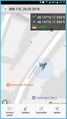
Logproof
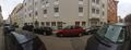
Panorama

Me@hash


Achievements
- Land Geohash