Difference between revisions of "2018-03-30 50 7"
From Geohashing
imported>Argus1972 (An expedition message sent via Geohash Droid for Android.) |
m |
||
| (6 intermediate revisions by 3 users not shown) | |||
| Line 19: | Line 19: | ||
== Location == | == Location == | ||
| − | + | ||
| + | The point is in the middle of an orchard. | ||
== Participants == | == Participants == | ||
| − | + | *[[User:argus1972|argus1972]] | |
| − | |||
== Plans == | == Plans == | ||
| Line 29: | Line 29: | ||
== Expedition == | == Expedition == | ||
| − | + | I was on my way with my bike. | |
== Tracklog == | == Tracklog == | ||
| Line 39: | Line 39: | ||
--> | --> | ||
<gallery perrow="5"> | <gallery perrow="5"> | ||
| + | |||
| + | Image:2018-03-30_50_7_argus1972_1524131938118.jpg|In between fruits [http://www.openstreetmap.org/?lat=50.80155840&lon=7.05952650&zoom=16&layers=B000FTF @50.8016,7.0595] | ||
</gallery> | </gallery> | ||
| Line 45: | Line 47: | ||
<!-- Add any achievement ribbons you earned below, or remove this section --> | <!-- Add any achievement ribbons you earned below, or remove this section --> | ||
| − | |||
| − | |||
| − | |||
| − | |||
| − | |||
| − | |||
| − | |||
| − | |||
| − | |||
| − | |||
| − | |||
| − | |||
| − | |||
| − | |||
[[Category:Expeditions]] | [[Category:Expeditions]] | ||
| − | |||
[[Category:Expeditions with photos]] | [[Category:Expeditions with photos]] | ||
| − | |||
| − | |||
| − | |||
| − | |||
| − | |||
[[Category:Coordinates reached]] | [[Category:Coordinates reached]] | ||
| − | + | {{location|DE|NW|SU}} | |
| − | |||
| − | |||
| − | |||
| − | |||
| − | |||
| − | |||
| − | |||
| − | |||
| − | |||
| − | |||
| − | |||
| − | |||
| − | |||
| − | |||
| − | |||
| − | |||
| − | |||
Latest revision as of 13:21, 18 March 2022
| Fri 30 Mar 2018 in 50,7: 50.8013055, 7.0598847 geohashing.info google osm bing/os kml crox |
Location
The point is in the middle of an orchard.
Participants
Plans
Expedition
I was on my way with my bike.
Tracklog
Photos
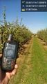
In between fruits @50.8016,7.0595
