Difference between revisions of "2018-04-02 49 8"
imported>DODO (→Participants) |
imported>FippeBot m (Location) |
||
| (7 intermediate revisions by one other user not shown) | |||
| Line 29: | Line 29: | ||
== Plans == | == Plans == | ||
<!-- what were the original plans --> | <!-- what were the original plans --> | ||
| + | Make a very short stop at Ludwigshafen main station on the way to my sister. | ||
== Expedition == | == Expedition == | ||
<!-- how it all turned out. your narrative goes here. --> | <!-- how it all turned out. your narrative goes here. --> | ||
| + | The hash was extremly friendly today. I had to go to my sister in Neuwied by train today, and it waited just 200m outside the Main station for me. So I just took an earlier Trainer, jumped oft at Ludwigshafen, Walker some minutes, returned to the station and continued the journey. | ||
| + | |||
| + | BY the way, with this hash started my hash-tour 2018. I will start from my sister and will try to visit the hash, that is closest by. After this I will try to visit the hash, that is closest to this one and so on until Friday. And I will only use public transport and my feet. I'm realy curious wherethe hash will lead me (well, I was on 2018-04-02, now, that I write this, I'm back home and know all about it: 7 successfull hashes in 6 days and so much beautiful landscape. And a lot of train riding). | ||
| + | |||
| + | Here you find [[2018-04-03_50_7|tomorrows hash]]. | ||
== Tracklog == | == Tracklog == | ||
| Line 40: | Line 46: | ||
Image:2012-##-## ## ## Alpha.jpg | Witty Comment | Image:2012-##-## ## ## Alpha.jpg | Witty Comment | ||
--> | --> | ||
| − | <gallery perrow=" | + | <gallery perrow="4"> |
| − | + | Image:2018-04-02_49_8-1.jpg|my first magnolia for this year | |
| + | Image:2018-04-02_49_8-2.jpg|View to the hash in 200 m | ||
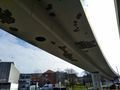
| + | Image:2018-04-02_49_8-7.jpg|proof | ||
| + | Image:2018-04-02_49_8-3.jpg|view upwards | ||
| + | Image:2018-04-02_49_8-4.jpg|to the south | ||
| + | Image:2018-04-02_49_8-5.jpg|... the west | ||
| + | Image:2018-04-02_49_8-6.jpg|and the north | ||
Image:2018-04-02_49_8_DODO_1522661068170.jpg|Happy hasher | Image:2018-04-02_49_8_DODO_1522661068170.jpg|Happy hasher | ||
| − | |||
| − | |||
</gallery> | </gallery> | ||
| Line 50: | Line 60: | ||
{{#vardefine:ribbonwidth|800px}} | {{#vardefine:ribbonwidth|800px}} | ||
<!-- Add any achievement ribbons you earned below, or remove this section --> | <!-- Add any achievement ribbons you earned below, or remove this section --> | ||
| + | {{land geohash | ||
| + | | latitude = 49 | ||
| + | | longitude =8 | ||
| + | | date = 2018-04-02 | ||
| + | | name = DODO | ||
| + | }} | ||
| − | + | {{Public transport geohash | |
| − | + | | latitude = 49 | |
| − | + | | longitude = 8 | |
| + | | date = 2018-04-02 | ||
| + | | name = DODO | ||
| + | }} | ||
| − | |||
| − | |||
| − | |||
| − | |||
| − | |||
| − | |||
| − | |||
| − | |||
| − | |||
| − | |||
[[Category:Expeditions]] | [[Category:Expeditions]] | ||
| − | |||
| − | |||
| − | |||
| − | |||
| − | |||
| − | |||
| − | |||
[[Category:Coordinates reached]] | [[Category:Coordinates reached]] | ||
| − | + | {{location|DE|RP|LU}} | |
| − | |||
| − | |||
| − | |||
| − | |||
| − | |||
| − | |||
| − | |||
| − | |||
| − | |||
| − | |||
| − | |||
| − | |||
| − | |||
| − | |||
| − | |||
| − | |||
| − | |||
Latest revision as of 02:56, 7 August 2019
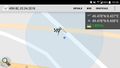
| Mon 2 Apr 2018 in 49,8: 49.4776046, 8.4374972 geohashing.info google osm bing/os kml crox |
Location
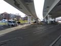
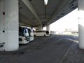
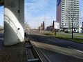
On - and under - a road next to Ludwigshafen main station.
Participants
Plans
Make a very short stop at Ludwigshafen main station on the way to my sister.
Expedition
The hash was extremly friendly today. I had to go to my sister in Neuwied by train today, and it waited just 200m outside the Main station for me. So I just took an earlier Trainer, jumped oft at Ludwigshafen, Walker some minutes, returned to the station and continued the journey.
BY the way, with this hash started my hash-tour 2018. I will start from my sister and will try to visit the hash, that is closest by. After this I will try to visit the hash, that is closest to this one and so on until Friday. And I will only use public transport and my feet. I'm realy curious wherethe hash will lead me (well, I was on 2018-04-02, now, that I write this, I'm back home and know all about it: 7 successfull hashes in 6 days and so much beautiful landscape. And a lot of train riding).
Here you find tomorrows hash.
Tracklog
Photos
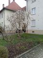
my first magnolia for this year
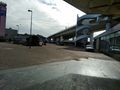
View to the hash in 200 m
proof
view upwards
to the south
... the west
and the north

Happy hasher


Achievements
DODO earned the Land geohash achievement
|
DODO earned the Public transport geohash achievement
|