Difference between revisions of "2018-04-05 35 -81"
From Geohashing
imported>HashPotato (→Photos) |
imported>Palmpje m (Show status) |
||
| Line 55: | Line 55: | ||
<!-- If all those plans are never acted upon, change [[Category:Expedition planning]] to [[Category:Not reached - Did not attempt]]. --> | <!-- If all those plans are never acted upon, change [[Category:Expedition planning]] to [[Category:Not reached - Did not attempt]]. --> | ||
| − | |||
[[Category:Expeditions]] | [[Category:Expeditions]] | ||
| − | |||
[[Category:Expeditions with photos]] | [[Category:Expeditions with photos]] | ||
| − | |||
| − | |||
| − | |||
| − | |||
[[Category:Coordinates reached]] | [[Category:Coordinates reached]] | ||
| − | |||
| − | |||
| − | |||
| − | |||
| − | |||
| − | |||
| − | |||
| − | |||
| − | |||
| − | |||
| − | |||
| − | |||
| − | |||
| − | |||
| − | |||
| − | |||
| − | |||
| − | |||
Revision as of 14:10, 6 April 2018
| Thu 5 Apr 2018 in 35,-81: 35.3297971, -81.5234316 geohashing.info google osm bing/os kml crox |
Location
This hash location is off of a dead end gravel road in the middle of a field. The gravel road appeared to not be a private drive.
Participants
HashPotato
Expedition
It was a beautiful drive on a warm spring evening. I drove down the road and took the pictures and left. I stopped at a convenience store near there for a quick snack before returning to the road.
Photos
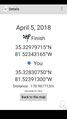
Proof!
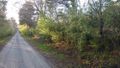
The gravel road

The convenience store
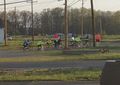
A group of local cyclists


