Difference between revisions of "2018-04-08 49 8"
From Geohashing
imported>Elimik31 (Created page with "{{subst:Expedition |lat = 49 |lon = 8 |date = 2018-04-08 }}") |
imported>Elimik31 |
||
| Line 1: | Line 1: | ||
| − | |||
| − | |||
| − | |||
| − | |||
| − | |||
| − | |||
| − | |||
| − | |||
| − | |||
| − | |||
{{meetup graticule | {{meetup graticule | ||
| lat=49 | | lat=49 | ||
| Line 15: | Line 5: | ||
}} | }} | ||
| − | |||
__NOTOC__ | __NOTOC__ | ||
== Location == | == Location == | ||
| − | + | At the riverbank of the Pfinz-Entlastungskanal, a small canal, not far from where it flows into the Rhine. In Eggenstein-Leopoldshafen, north of Karlsruhe. | |
== Participants == | == Participants == | ||
| − | + | * [[user:elimik31|elimik31]] | |
| − | |||
| − | |||
| − | |||
| − | |||
== Expedition == | == Expedition == | ||
| − | + | Haven't done any geohashing in a long time, but the weather was so perfect today and the geohash was in such a nice and near location, that I decided to go outside take a bicycle ride to the hash location. Was pretty straightforward, I knew the way to the canal and from there I just had to follow it. Before returning home, I made a small detour to the Rhine. | |
| − | |||
| − | |||
== Photos == | == Photos == | ||
| − | |||
| − | |||
| − | |||
<gallery perrow="5"> | <gallery perrow="5"> | ||
| + | Image:Pfinz_entlastungskanal_wasserfall.jpg | on the way to the hash location, following the canal | ||
| + | Image:Hash_location.jpg | at the geohash location | ||
| + | Image:Rhine_belle.jpg | Rhine river, next to the former river arm "Belle" | ||
</gallery> | </gallery> | ||
| − | |||
| − | |||
| − | |||
| − | |||
| − | |||
| − | |||
| − | |||
| − | |||
| − | |||
| − | |||
| − | |||
| − | |||
| − | |||
| − | |||
| − | |||
| − | |||
| − | |||
| − | |||
[[Category:Expeditions]] | [[Category:Expeditions]] | ||
| − | |||
[[Category:Expeditions with photos]] | [[Category:Expeditions with photos]] | ||
| − | |||
| − | |||
| − | |||
| − | |||
| − | |||
[[Category:Coordinates reached]] | [[Category:Coordinates reached]] | ||
| − | |||
| − | |||
| − | |||
| − | |||
| − | |||
| − | |||
| − | |||
| − | |||
| − | |||
| − | |||
| − | |||
| − | |||
| − | |||
| − | |||
| − | |||
| − | |||
| − | |||
| − | |||
Revision as of 20:49, 8 April 2018
| Sun 8 Apr 2018 in 49,8: 49.0976469, 8.3801425 geohashing.info google osm bing/os kml crox |
Location
At the riverbank of the Pfinz-Entlastungskanal, a small canal, not far from where it flows into the Rhine. In Eggenstein-Leopoldshafen, north of Karlsruhe.
Participants
Expedition
Haven't done any geohashing in a long time, but the weather was so perfect today and the geohash was in such a nice and near location, that I decided to go outside take a bicycle ride to the hash location. Was pretty straightforward, I knew the way to the canal and from there I just had to follow it. Before returning home, I made a small detour to the Rhine.
Photos
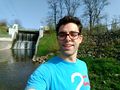
on the way to the hash location, following the canal
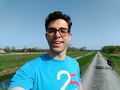
at the geohash location
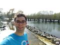
Rhine river, next to the former river arm "Belle"


