Difference between revisions of "2018-04-09 48 11"
From Geohashing
imported>Claralucia9 (→Expedition) |
m |
||
| (6 intermediate revisions by 3 users not shown) | |||
| Line 22: | Line 22: | ||
== Participants == | == Participants == | ||
| − | claralucia9 | + | *[[User:clearlucid9|claralucia9]] |
== Plans == | == Plans == | ||
| Line 28: | Line 28: | ||
== Expedition == | == Expedition == | ||
| − | It's not that often that the hashpoint gets as close to home. So I knew that I had to go there today. Fortunately the point was just a view meters | + | It's not that often that the hashpoint gets as close to home. So I knew that I had to go there today. Fortunately the point was just a view meters off from a walking path between the fields. The fields were already prepared, but no crops had been planted yet - as far as I could see. As the hash was far from any trees and buildings and GPS reception was very good, I got within less than 1m to the hashpoint. To the east you could see the Airbus Defence and Space centre. |
An easy hash today... | An easy hash today... | ||
| Line 41: | Line 41: | ||
Image:2018-04-09_48_11_Claralucia9_1523286231181.jpg|Logproof | Image:2018-04-09_48_11_Claralucia9_1523286231181.jpg|Logproof | ||
| + | |||
| + | Image:2018-04-09_48_11_Claralucia9_1523344475519.jpg|Me - right there... | ||
| + | |||
| + | Image:2018-04-09_48_11_Claralucia9_1523344514622.jpg|Looking west | ||
| + | |||
| + | Image:2018-04-09_48_11_Claralucia9_1523344576497.jpg|Looking east - Airbus at the horizon | ||
</gallery> | </gallery> | ||
| Line 49: | Line 55: | ||
<!-- =============== USEFUL CATEGORIES FOLLOW ================ | <!-- =============== USEFUL CATEGORIES FOLLOW ================ | ||
Delete the next line ONLY if you have chosen the appropriate categories below. If you are unsure, don't worry. People will read your report and help you with the classification. --> | Delete the next line ONLY if you have chosen the appropriate categories below. If you are unsure, don't worry. People will read your report and help you with the classification. --> | ||
| − | |||
| − | |||
| − | |||
| − | |||
| − | |||
| − | |||
| − | |||
| − | |||
| − | |||
| − | |||
| − | |||
| − | |||
[[Category:Expeditions]] | [[Category:Expeditions]] | ||
| − | |||
[[Category:Expeditions with photos]] | [[Category:Expeditions with photos]] | ||
| − | |||
| − | |||
| − | |||
| − | |||
| − | |||
[[Category:Coordinates reached]] | [[Category:Coordinates reached]] | ||
| − | + | {{location|DE|BY|M}} | |
| − | |||
| − | |||
| − | |||
| − | |||
| − | |||
| − | |||
| − | |||
| − | |||
| − | |||
| − | |||
| − | |||
| − | |||
| − | |||
| − | |||
| − | |||
| − | |||
| − | |||
Latest revision as of 13:20, 18 March 2022
| Mon 9 Apr 2018 in 48,11: 48.0440903, 11.6357555 geohashing.info google osm bing/os kml crox |
Location
in a field between Taufkirchen and Ottobrunn, south of Munich
Participants
Plans
Expedition
It's not that often that the hashpoint gets as close to home. So I knew that I had to go there today. Fortunately the point was just a view meters off from a walking path between the fields. The fields were already prepared, but no crops had been planted yet - as far as I could see. As the hash was far from any trees and buildings and GPS reception was very good, I got within less than 1m to the hashpoint. To the east you could see the Airbus Defence and Space centre. An easy hash today...
Tracklog
Photos
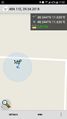
Logproof
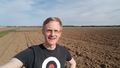
Me - right there...
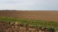
Looking west
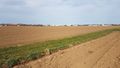
Looking east - Airbus at the horizon


