Difference between revisions of "2018-04-15 49 6"
imported>Fakusb (→Location) |
imported>FippeBot m (Location) |
||
| (2 intermediate revisions by 2 users not shown) | |||
| Line 46: | Line 46: | ||
--> | --> | ||
<gallery perrow="5"> | <gallery perrow="5"> | ||
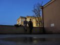
| + | Image:2018-04-15 49 6 landtag 002.JPG | Landtag of Saarland is visible in the back | ||
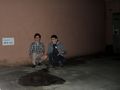
| + | Image:2018-04-15 49 6 the-puddle 003.JPG | proud first time geohashers | ||
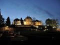
| + | Image:2018-04-15 49 6 saarbrucken castle 004.JPG | Saarbrücken Castle | ||
</gallery> | </gallery> | ||
| Line 52: | Line 55: | ||
<!-- Add any achievement ribbons you earned below, or remove this section --> | <!-- Add any achievement ribbons you earned below, or remove this section --> | ||
| − | |||
| − | |||
| − | |||
| − | |||
| − | |||
| − | |||
| − | |||
| − | |||
| − | |||
| − | |||
| − | |||
| − | |||
| − | |||
| − | |||
[[Category:Expeditions]] | [[Category:Expeditions]] | ||
| − | |||
[[Category:Expeditions with photos]] | [[Category:Expeditions with photos]] | ||
| − | |||
| − | |||
| − | |||
| − | |||
| − | |||
[[Category:Coordinates reached]] | [[Category:Coordinates reached]] | ||
| − | + | {{location|DE|SL|SB}} | |
| − | |||
| − | |||
| − | |||
| − | |||
| − | |||
| − | |||
| − | |||
| − | |||
| − | |||
| − | |||
| − | |||
| − | |||
| − | |||
| − | |||
| − | |||
| − | |||
| − | |||
Latest revision as of 18:39, 26 July 2019
| Sun 15 Apr 2018 in 49,6: 49.2293157, 6.9934375 geohashing.info google osm bing/os kml crox |
Location
On a parking lot directly behind the Landtag (State Parliament) of Saarland. A small puddle marked the exact spot.
Participants
Plans
Expedition
We had though about doing geohashing for a while and couldn't resist this low-hanging fruit as our first geohash. It was a spontaneous trip without much planning, though the good accessibility did not require much preparation anyway. We drove there by bike and located the spot on a small parking lot behind the green area next to the Landtag. There was also some kind of air vent of the size of a garage door, with a massive steel door to seal it off, so there is probably some air raid shelter close by.
It was already rather dark, but you get a nice view on the city and the Saarbrücken Castle. Afterwards we cycled to Staden and played table tennis in the dark because the local flood lights did not work.
- Better late then never! -- Fakusb (talk) @49.2293,6.9935 21:09, 15 April 2018 (GMT+02:00)
Tracklog
Photos
Landtag of Saarland is visible in the back
proud first time geohashers
Saarbrücken Castle


