Difference between revisions of "2018-04-18 35 -81"
imported>HashPotato (Created page with " <!-- If you did not specify these parameters in the template, please substitute appropriate values for IMAGE, LAT, LON, and DATE (YYYY-MM-DD format) Image:{{{image|IMAGE}...") |
imported>HashPotato |
||
| Line 25: | Line 25: | ||
== Expedition == | == Expedition == | ||
| − | I drove to the trailhead and continued the rest of the way on foot. This area is quite hilly and I had no way of knowing if the trails would get me close to the hash location, but I decided to try anyway. I walked about a mile to a spot on the trail that was about 20 meters from the hash point, so it turned out to be very easy to get to. I | + | I drove to the trailhead and continued the rest of the way on foot. This area is quite hilly and I had no way of knowing if the trails would get me close to the hash location, but I decided to try anyway. I walked about a mile to a spot on the trail that was about 20 meters from the hash point, so it turned out to be very easy to get to. I ventured off the trail and ambled around in circles a bit before I grabbed my screenshot proof. The trail continued into South Carolina but I decided I wanted to get home. Maybe another day! It was a lovely day and I never saw another soul until I was back in the parking lot getting in my car. |
== Photos == | == Photos == | ||
Revision as of 03:16, 19 April 2018
| Wed 18 Apr 2018 in 35,-81: 35.1662278, -81.3692169 geohashing.info google osm bing/os kml crox |
Location
Today's hash was located in Crowders Mountain State Park, at the Boulders Access Area.
Participants
HashPotato
Expedition
I drove to the trailhead and continued the rest of the way on foot. This area is quite hilly and I had no way of knowing if the trails would get me close to the hash location, but I decided to try anyway. I walked about a mile to a spot on the trail that was about 20 meters from the hash point, so it turned out to be very easy to get to. I ventured off the trail and ambled around in circles a bit before I grabbed my screenshot proof. The trail continued into South Carolina but I decided I wanted to get home. Maybe another day! It was a lovely day and I never saw another soul until I was back in the parking lot getting in my car.
Photos
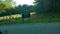
The entrance to the park
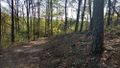
The trail
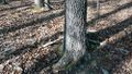
The hashpoint was on the other side of this tree.
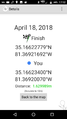
Proof!
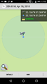
More proof!
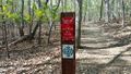
GPS marker that was down the trail a little bit farther.


