Difference between revisions of "2018-04-19 50 7"
From Geohashing
imported>Argus1972 (→Location) |
m |
||
| (6 intermediate revisions by 4 users not shown) | |||
| Line 19: | Line 19: | ||
== Location == | == Location == | ||
| − | + | Field near the L300 in Bonn | |
== Participants == | == Participants == | ||
| − | + | *[[User:argus1972|argus1972]] | |
| − | |||
== Plans == | == Plans == | ||
| Line 31: | Line 30: | ||
That was near! | That was near! | ||
I grabbed my bike, just took the ferry across the Rhine and reached the hash just minutes later. | I grabbed my bike, just took the ferry across the Rhine and reached the hash just minutes later. | ||
| − | The location wasn´t that exiting. I stood in the fields next to a | + | The location wasn´t that exiting. I stood in the fields next to a busy road, but it could have been worse. |
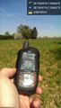
Anyway it was possible to reach the location exactly. | Anyway it was possible to reach the location exactly. | ||
| Line 47: | Line 46: | ||
== Achievements == | == Achievements == | ||
| − | |||
| − | |||
| − | |||
| − | |||
| − | |||
| − | |||
| − | |||
| − | |||
| − | |||
| − | |||
| − | |||
| − | |||
| − | |||
| − | |||
| − | |||
| − | |||
| − | |||
[[Category:Expeditions]] | [[Category:Expeditions]] | ||
| − | |||
[[Category:Expeditions with photos]] | [[Category:Expeditions with photos]] | ||
| − | |||
| − | |||
| − | |||
| − | |||
| − | |||
[[Category:Coordinates reached]] | [[Category:Coordinates reached]] | ||
| − | + | {{location|DE|NW|SU}} | |
| − | |||
| − | |||
| − | |||
| − | |||
| − | |||
| − | |||
| − | |||
| − | |||
| − | |||
| − | |||
| − | |||
| − | |||
| − | |||
| − | |||
| − | |||
| − | |||
| − | |||
Latest revision as of 13:19, 18 March 2022
| Thu 19 Apr 2018 in 50,7: 50.7634450, 7.0566386 geohashing.info google osm bing/os kml crox |
Location
Field near the L300 in Bonn
Participants
Plans
Expedition
That was near! I grabbed my bike, just took the ferry across the Rhine and reached the hash just minutes later. The location wasn´t that exiting. I stood in the fields next to a busy road, but it could have been worse. Anyway it was possible to reach the location exactly.
Tracklog
Photos
Nur eben über den Rhein und ich war da. @50.7634,7.0566
