Difference between revisions of "2018-04-20 43 -79"
imported>Frogman (An expedition message sent via Geohash Droid for Android.) |
(→Achievements: not the last in my subdivision achievement) |
||
| (8 intermediate revisions by 4 users not shown) | |||
| Line 1: | Line 1: | ||
| + | [[Image:{{{image|2018-04-20 43 -79 frogman 1524269320876.jpg}}}|thumb|left]] | ||
| − | |||
| − | |||
| − | |||
| − | |||
| − | |||
| − | |||
| − | |||
| − | |||
| − | |||
{{meetup graticule | {{meetup graticule | ||
| lat=43 | | lat=43 | ||
| Line 19: | Line 11: | ||
== Location == | == Location == | ||
| − | + | The south crosswalk of the Royal York and Allanhurst intersection in Etobicoke. | |
== Participants == | == Participants == | ||
| − | + | *[[User:Frogman|Frogman]] | |
| − | |||
== Plans == | == Plans == | ||
| − | + | I saw that this was doable in the morning. I asked if any coworkers wanted to spend their Friday evening going an hour out of their way to cross a street. The mumbled something non-committal and then changed the subject, so I went alone. | |
== Expedition == | == Expedition == | ||
| − | + | I took the subway to Royal York station, and then the bus north. Royal York buses don't stop at the station. It's unclear if that's a temporary thing or if there's just no bus bay there. Either way, it was a little confusing as to what I was supposed to do. After a while, a bus showed up, which made it less confusing. | |
| − | + | Royal York goes through a relatively hilly suburban area, with houses that were a bit larger than I am used to seeing in Toronto. The hashpoint itself was in the middle of a crosswalk, near a park. I snapped some pictures, crossed the street (so I could be sure I reached the hashpoint), and headed up to nearby Eglinton Avenue. I took the Eglinton West bus to Eglinton West station, which was overall a less direct route than simply returning on the Royal York bus, but took me past some Line 5 construction sites which I was interested in seeing. | |
| − | |||
== Photos == | == Photos == | ||
| Line 39: | Line 29: | ||
--> | --> | ||
<gallery perrow="5"> | <gallery perrow="5"> | ||
| + | |||
| + | Image:2018-04-20_43_-79_frogman_1524269320876.jpg|The intersection. | ||
| + | |||
| + | Image:2018-04-20_43_-79_frogman_1524269335843.jpg|The park. | ||
| + | |||
| + | Image:2018-04-20_43_-79_frogman_1524269346064.jpg|The proof. | ||
| + | |||
| + | Image:2018-04-20_43_-79_frogman_1524269355278.jpg|The grin. | ||
</gallery> | </gallery> | ||
| Line 45: | Line 43: | ||
<!-- Add any achievement ribbons you earned below, or remove this section --> | <!-- Add any achievement ribbons you earned below, or remove this section --> | ||
| − | + | {{Public transport geohash | |
| − | |||
| − | |||
| − | |||
| − | |||
| − | + | | latitude = 43 | |
| − | + | | longitude = -79 | |
| − | [[ | + | | date = 2018-04-20 |
| − | + | | busline = the TTC | |
| + | | name = [[User:Frogman|Frogman]] | ||
| − | + | }} | |
| − | |||
[[Category:Expeditions]] | [[Category:Expeditions]] | ||
| − | |||
[[Category:Expeditions with photos]] | [[Category:Expeditions with photos]] | ||
| − | |||
| − | |||
| − | |||
| − | |||
| − | |||
[[Category:Coordinates reached]] | [[Category:Coordinates reached]] | ||
| − | + | {{location|CA|ON|TO}} | |
| − | |||
| − | |||
| − | |||
| − | |||
| − | |||
| − | |||
| − | |||
| − | |||
| − | |||
| − | |||
| − | |||
| − | |||
| − | |||
| − | |||
| − | |||
| − | |||
| − | |||
Latest revision as of 23:02, 13 July 2022

| Fri 20 Apr 2018 in 43,-79: 43.6792237, -79.5252103 geohashing.info google osm bing/os kml crox |
Location
The south crosswalk of the Royal York and Allanhurst intersection in Etobicoke.
Participants
Plans
I saw that this was doable in the morning. I asked if any coworkers wanted to spend their Friday evening going an hour out of their way to cross a street. The mumbled something non-committal and then changed the subject, so I went alone.
Expedition
I took the subway to Royal York station, and then the bus north. Royal York buses don't stop at the station. It's unclear if that's a temporary thing or if there's just no bus bay there. Either way, it was a little confusing as to what I was supposed to do. After a while, a bus showed up, which made it less confusing.
Royal York goes through a relatively hilly suburban area, with houses that were a bit larger than I am used to seeing in Toronto. The hashpoint itself was in the middle of a crosswalk, near a park. I snapped some pictures, crossed the street (so I could be sure I reached the hashpoint), and headed up to nearby Eglinton Avenue. I took the Eglinton West bus to Eglinton West station, which was overall a less direct route than simply returning on the Royal York bus, but took me past some Line 5 construction sites which I was interested in seeing.
Photos
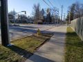
The intersection.
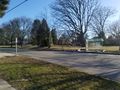
The park.
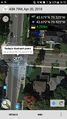
The proof.
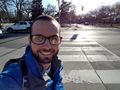
The grin.


Achievements
Frogman earned the Public transport geohash achievement
|