Difference between revisions of "2018-05-19 48 11"
imported>Claralucia9 (An expedition message sent via Geohash Droid for Android.) |
m |
||
| (16 intermediate revisions by 3 users not shown) | |||
| Line 19: | Line 19: | ||
== Location == | == Location == | ||
| − | + | Next to a tiny road between Ilching and Kirchseeon, south-east of Munich | |
== Participants == | == Participants == | ||
| − | + | *[[User:Clearlucid9|Claralucia9]] | |
| − | |||
== Plans == | == Plans == | ||
| Line 29: | Line 28: | ||
== Expedition == | == Expedition == | ||
| − | + | When I looked at todays coordinates yesterday I figured that they wouldn't be too far away. Next I had a look at geocaches close by and immediately found more than 20 boxes in the vicinity. So it was settled, that I had t go there this morning. Leaving the house as early as 6:30 I arrived at the coordinates just before 7a.m. | |
| + | From the map I thought I would need to walk or cycle a bit, but approaching the coordinates I realised that this tiny road was actually open for traffic. So I tried to park the car on the roadside which was quite muddy due to the rain earlier this week and just hoped I would not get stucked. Getting to the coordinates from the car was easy, as I parked about 10 m off the final spot. There I took the pictures and then realised that the first geocache of today was only 250m away. After finding a total of 4 geocaches I returned home. | ||
== Tracklog == | == Tracklog == | ||
| Line 35: | Line 35: | ||
== Photos == | == Photos == | ||
| − | |||
| − | |||
| − | |||
<gallery perrow="5"> | <gallery perrow="5"> | ||
| + | |||
| + | Image:2018-05-19_48_11_Claralucia9_1526713349741.jpg|Logproof | ||
| + | |||
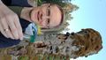
| + | Image:2018-05-19_48_11_Claralucia9_1526713381600.jpg|Sunny morning & me | ||
| + | |||
| + | Image:2018-05-19_48_11_Claralucia9_1526713453521.jpg|In the forrest | ||
| + | |||
| + | Image:2018-05-19_48_11_Claralucia9_1526713494609.jpg|Road near hash | ||
| + | |||
| + | Image:2018-05-19_48_11_Claralucia9_1526713515294.jpg|Trees... | ||
| + | |||
| + | Image:2018-05-19_48_11_Claralucia9_1526713547337.jpg|Gecoache close by | ||
</gallery> | </gallery> | ||
| Line 45: | Line 54: | ||
<!-- Add any achievement ribbons you earned below, or remove this section --> | <!-- Add any achievement ribbons you earned below, or remove this section --> | ||
| − | |||
| − | |||
| − | |||
| − | |||
| − | |||
| − | |||
| − | |||
| − | |||
| − | |||
| − | |||
| − | |||
| − | |||
| − | |||
| − | |||
[[Category:Expeditions]] | [[Category:Expeditions]] | ||
| − | |||
[[Category:Expeditions with photos]] | [[Category:Expeditions with photos]] | ||
| − | |||
| − | |||
| − | |||
| − | |||
| − | |||
[[Category:Coordinates reached]] | [[Category:Coordinates reached]] | ||
| − | + | {{location|DE|BY|EBE}} | |
| − | |||
| − | |||
| − | |||
| − | |||
| − | |||
| − | |||
| − | |||
| − | |||
| − | |||
| − | |||
| − | |||
| − | |||
| − | |||
| − | |||
| − | |||
| − | |||
| − | |||
Latest revision as of 13:18, 18 March 2022
| Sat 19 May 2018 in 48,11: 48.0687664, 11.8761435 geohashing.info google osm bing/os kml crox |
Location
Next to a tiny road between Ilching and Kirchseeon, south-east of Munich
Participants
Plans
Expedition
When I looked at todays coordinates yesterday I figured that they wouldn't be too far away. Next I had a look at geocaches close by and immediately found more than 20 boxes in the vicinity. So it was settled, that I had t go there this morning. Leaving the house as early as 6:30 I arrived at the coordinates just before 7a.m. From the map I thought I would need to walk or cycle a bit, but approaching the coordinates I realised that this tiny road was actually open for traffic. So I tried to park the car on the roadside which was quite muddy due to the rain earlier this week and just hoped I would not get stucked. Getting to the coordinates from the car was easy, as I parked about 10 m off the final spot. There I took the pictures and then realised that the first geocache of today was only 250m away. After finding a total of 4 geocaches I returned home.
Tracklog
Photos

Logproof

Sunny morning & me
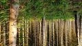
In the forrest
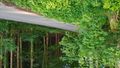
Road near hash
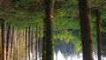
Trees...
Gecoache close by


