Difference between revisions of "2018-06-09 51 -0"
imported>Saxbophone (→Photos) |
m |
||
| (18 intermediate revisions by 3 users not shown) | |||
| Line 1: | Line 1: | ||
| + | [[Image:2018-06-09_51_-0_closest_location.png|thumb|300 px|The target location of this Geohash was just beyond here!]] | ||
| + | |||
{{meetup graticule | {{meetup graticule | ||
| map=<map lat="51" lon="-0" date="2018-06-09" /> | | map=<map lat="51" lon="-0" date="2018-06-09" /> | ||
| Line 12: | Line 14: | ||
== Location == | == Location == | ||
| − | + | '''51.55635195, -0.01162483''', inside the corner of a house within a Gated Community called Witham Court in Leyton, London, United Kingdom. | |
== Participants == | == Participants == | ||
* [[User:Saxbophone|Saxbophone]] ([[User talk:Saxbophone|talk]]) | * [[User:Saxbophone|Saxbophone]] ([[User talk:Saxbophone|talk]]) | ||
| + | * Saxbophone's Mother | ||
| + | * Saxbophone's Sister | ||
| + | * Saxbophone's Dog | ||
== Plans == | == Plans == | ||
| Line 23: | Line 28: | ||
We set out at about 15:10, BST. It was a largely leisurely stroll though residential streets. The weather was not bad walking weather, warm but not hot and moderately humid. | We set out at about 15:10, BST. It was a largely leisurely stroll though residential streets. The weather was not bad walking weather, warm but not hot and moderately humid. | ||
| − | Points of interest we passed included Leyton Orient Football Stadium and the Coronation Gardens in Leyton. | + | Points of interest we passed included Leyton Orient Football Stadium and the Coronation Gardens in Leyton. I also found a portable lifting machine parked rather unusually by the road side, with its lifting platform extended by quite a way! |
About halfway along our journey, we met my sister who then proceeded to accompany us. We also stopped at a newsagents shortly after this to get some snacks. | About halfway along our journey, we met my sister who then proceeded to accompany us. We also stopped at a newsagents shortly after this to get some snacks. | ||
| Line 29: | Line 34: | ||
We knew before we set out that we would not be able to reach the precise exact location of this Geohash, as the exact location falls within a private residence, itself within a gated community. We instead opted to get as close as we could whilst remaining on public rights of way and managed to reach two locations in pursuit of this. | We knew before we set out that we would not be able to reach the precise exact location of this Geohash, as the exact location falls within a private residence, itself within a gated community. We instead opted to get as close as we could whilst remaining on public rights of way and managed to reach two locations in pursuit of this. | ||
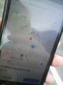
| − | * The first location we were able to reach was the main gate of the gated community itself at '''51.556932, -0.011566''', which we marked with a quick photo of myself in front of the gate as well as a quick poor quality snap of our location marked on a smartphone map (I don't have a smartphone so had to photograph the map shown on someone else's!). This location was 64 metres north of the target[http://boulter.com/gps/distance/?from=51.556352%2C-0.011625&to=51.556932%2C-0.011566&units=k]. | + | * The first location we were able to reach was the main gate of the gated community itself at '''51.556932, -0.011566''', which we marked with a quick photo of myself in front of the gate as well as a quick poor quality snap of our location marked on a smartphone map (I don't have a smartphone so had to photograph the map shown on someone else's!). This location was 64 metres north of the target[http://boulter.com/gps/distance/?from=51.556352%2C-0.011625&to=51.556932%2C-0.011566&units=k]. Also, I was rather chuffed to manage to reach this location dead-on 16:00 hours! |
* The second location we were able to reach was a point within the carpark of the nearby ASDA Store at Leyton Mills shopping park, at '''51.555984, -0.011272'''. This we also marked with a quick photo of both myself at the location and a map displayed on a smartphone. This point was marginally closer to the Geohash than the previous (47 metres south of it![http://boulter.com/gps/distance/?from=51.556352%2C-0.011625&to=51.555984%2C-0.011272&units=k]), though I forwent any plans to venture out onto the grassy area next to the car park (which would have brought me much closer at '''51.556210, -0.011620''', which is 15 metres south of the target[http://boulter.com/gps/distance/?from=51.556352%2C-0.011625&to=51.556210%2C-0.011620&units=k]) due to not being sure if the land was public or not. | * The second location we were able to reach was a point within the carpark of the nearby ASDA Store at Leyton Mills shopping park, at '''51.555984, -0.011272'''. This we also marked with a quick photo of both myself at the location and a map displayed on a smartphone. This point was marginally closer to the Geohash than the previous (47 metres south of it![http://boulter.com/gps/distance/?from=51.556352%2C-0.011625&to=51.555984%2C-0.011272&units=k]), though I forwent any plans to venture out onto the grassy area next to the car park (which would have brought me much closer at '''51.556210, -0.011620''', which is 15 metres south of the target[http://boulter.com/gps/distance/?from=51.556352%2C-0.011625&to=51.556210%2C-0.011620&units=k]) due to not being sure if the land was public or not. | ||
| Line 36: | Line 41: | ||
Image:2012-##-## ## ## Alpha.jpg | Witty Comment | Image:2012-##-## ## ## Alpha.jpg | Witty Comment | ||
--> | --> | ||
| − | <gallery | + | <gallery> |
| + | Image:2018-06-09_51_-0_saxbophone_notes.jpeg | My notes noting the target Geohash and alternative locations in advance of the expedition | ||
| + | Image:2018-06-09_51_-0_saxbophone_leyton_orient_fc.jpeg | Leyton Orient Football Club is a hardy landmark! | ||
| + | Image:2018-06-09_51_-0_saxbophone_coronation_gardens_1.jpeg | Coronation Gardens in Leyton are rather picturesque! | ||
| + | Image:2018-06-09_51_-0_saxbophone_silly_lifting_platform.jpeg | What a silly place to leave one of these lifting platform thingies, and while fully-extended too! | ||
| + | Image:2018-06-09_51_-0_saxbophone_first_location_proof.jpg | "Proof" (if you can call it that) of my visit to 51.556932, -0.011566 which is 64 metres away from the target location. I had to borrow someone else's smartphone and photograph it as I don't have one currently! | ||
Image:2018-06-09_51_-0_closest_location.png | The target location of this Geohash was just beyond here! | Image:2018-06-09_51_-0_closest_location.png | The target location of this Geohash was just beyond here! | ||
Image:2018-06-09_51_-0_saxbophone_at_closest_location.jpeg | [[User:Saxbophone|Saxbophone]] staring gormlessly into the distance at the closest point he got to the geohash location. | Image:2018-06-09_51_-0_saxbophone_at_closest_location.jpeg | [[User:Saxbophone|Saxbophone]] staring gormlessly into the distance at the closest point he got to the geohash location. | ||
| + | Image:2018-06-09_51_-0_saxbophone_second_location_proof.jpg | More "Proof" that I visited a location near the Geohash target at 51.555984, -0.011272 —this one was a bit closer, 47 metres away from the target. | ||
| + | |||
</gallery> | </gallery> | ||
| Line 44: | Line 56: | ||
{{#vardefine:ribbonwidth|800px}} | {{#vardefine:ribbonwidth|800px}} | ||
<!-- Add any achievement ribbons you earned below, or remove this section --> | <!-- Add any achievement ribbons you earned below, or remove this section --> | ||
| + | {{No trespassing | latitude = 51 | longitude = -0 | date = 2018-06-09 | name = Saxbophone | distance = 47m }} | ||
| − | |||
| − | |||
| − | |||
| − | |||
| − | |||
| − | |||
| − | |||
| − | |||
| − | |||
| − | |||
| − | |||
| − | |||
| − | |||
| − | |||
[[Category:Expeditions]] | [[Category:Expeditions]] | ||
| − | |||
[[Category:Expeditions with photos]] | [[Category:Expeditions with photos]] | ||
| − | |||
| − | |||
| − | |||
| − | |||
| − | |||
| − | |||
| − | |||
| − | |||
| − | |||
[[Category:Coordinates not reached]] | [[Category:Coordinates not reached]] | ||
| − | |||
| − | |||
| − | |||
| − | |||
| − | |||
[[Category:Not reached - No public access]] | [[Category:Not reached - No public access]] | ||
| − | + | [[Category:Barriers]] | |
| − | + | [[Category:Beard]] | |
| − | [[Category: | + | [[Category:Dogs]] |
| − | + | {{location|GB|ENG|WFT}} | |
| − | |||
| − | [[Category: | ||
| − | |||
| − | |||
Latest revision as of 13:07, 23 September 2021

| Sat 9 Jun 2018 in London West: 51.5563519, -0.0116248 geohashing.info google osm bing/os kml crox |
Location
51.55635195, -0.01162483, inside the corner of a house within a Gated Community called Witham Court in Leyton, London, United Kingdom.
Participants
- Saxbophone (talk)
- Saxbophone's Mother
- Saxbophone's Sister
- Saxbophone's Dog
Plans
To get as close to the Geohashing location as possible, will probably have to stop at the gate of the gated community at 51.556932, -0.011566. It may be possible to get closer by visiting coördinates 51.556210, -0.011620, but public access rights to this location are less clear, though it is a patch of grass just off of a public right of way. I will also walk my dog with my mum at the same time.
Expedition
We set out at about 15:10, BST. It was a largely leisurely stroll though residential streets. The weather was not bad walking weather, warm but not hot and moderately humid.
Points of interest we passed included Leyton Orient Football Stadium and the Coronation Gardens in Leyton. I also found a portable lifting machine parked rather unusually by the road side, with its lifting platform extended by quite a way!
About halfway along our journey, we met my sister who then proceeded to accompany us. We also stopped at a newsagents shortly after this to get some snacks.
We knew before we set out that we would not be able to reach the precise exact location of this Geohash, as the exact location falls within a private residence, itself within a gated community. We instead opted to get as close as we could whilst remaining on public rights of way and managed to reach two locations in pursuit of this.
- The first location we were able to reach was the main gate of the gated community itself at 51.556932, -0.011566, which we marked with a quick photo of myself in front of the gate as well as a quick poor quality snap of our location marked on a smartphone map (I don't have a smartphone so had to photograph the map shown on someone else's!). This location was 64 metres north of the target[1]. Also, I was rather chuffed to manage to reach this location dead-on 16:00 hours!
- The second location we were able to reach was a point within the carpark of the nearby ASDA Store at Leyton Mills shopping park, at 51.555984, -0.011272. This we also marked with a quick photo of both myself at the location and a map displayed on a smartphone. This point was marginally closer to the Geohash than the previous (47 metres south of it![2]), though I forwent any plans to venture out onto the grassy area next to the car park (which would have brought me much closer at 51.556210, -0.011620, which is 15 metres south of the target[3]) due to not being sure if the land was public or not.
Photos
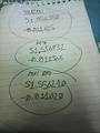
My notes noting the target Geohash and alternative locations in advance of the expedition

Leyton Orient Football Club is a hardy landmark!
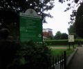
Coronation Gardens in Leyton are rather picturesque!
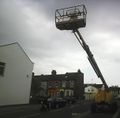
What a silly place to leave one of these lifting platform thingies, and while fully-extended too!
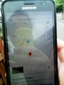
"Proof" (if you can call it that) of my visit to 51.556932, -0.011566 which is 64 metres away from the target location. I had to borrow someone else's smartphone and photograph it as I don't have one currently!
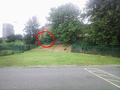
The target location of this Geohash was just beyond here!

Saxbophone staring gormlessly into the distance at the closest point he got to the geohash location.
More "Proof" that I visited a location near the Geohash target at 51.555984, -0.011272 —this one was a bit closer, 47 metres away from the target.


Achievements
Saxbophone earned the No trespassing consolation prize
|