Difference between revisions of "2018-06-23 42 -78"
imported>Pedalpusher (new expedition report) |
imported>Pedalpusher (added pictures) |
||
| Line 14: | Line 14: | ||
I did grab my GPS just in case I couldn't locate the hash accurately and I was on my way. | I did grab my GPS just in case I couldn't locate the hash accurately and I was on my way. | ||
| − | Here's where things get interesting, but I can't remember exactly what happened. The route I have written down IS a Tron route, but I distinctly recall driving and then suddenly realizing I just screwed up my path for the way home (or thought I did). I just can't pin down if I changed my route slightly on the fly going there or if I just THOUGHT I wrote down the directions wrong. Regardless, I made it to the Tops plaza and was very careful going in not to miss my turn. | + | Here's where things get interesting, but I can't remember exactly what happened. The route I have written down IS a Tron route, but I distinctly recall driving and then suddenly realizing I just screwed up my path for the way home (or thought I did). I just can't pin down if I changed my route slightly on the fly going there or if I just THOUGHT (while I was driving) that I wrote down the directions wrong. I'm thinking instead of continuing on Abbot as the directions say, I took Milestrip (Rt 179) to Rt 219 North at that exit and in doing so went UNDER the 219 first. That would mean if I came back on Milestrip, I would cross my path getting back on the 219 South. Regardless, I made it to the Tops plaza and was very careful going in not to miss my turn. |
I counted off the aisles found the one I was looking for, and saw the parking lot island by the hash. I then slowly drove through the seagulls hanging out in the hash area and took some pictures as I drove up, and by the hash. I then took a few extra looking back at the building for additional reference points. Success had, I now had to make it home without crossing my path. I basically just took Union and Rt. 277 all the way past Orchard Park to insure I'd miss my earlier path and got back to Hamburg on the back routes. | I counted off the aisles found the one I was looking for, and saw the parking lot island by the hash. I then slowly drove through the seagulls hanging out in the hash area and took some pictures as I drove up, and by the hash. I then took a few extra looking back at the building for additional reference points. Success had, I now had to make it home without crossing my path. I basically just took Union and Rt. 277 all the way past Orchard Park to insure I'd miss my earlier path and got back to Hamburg on the back routes. | ||
| − | I know | + | I know completed a Tron route, but writing this up months later, I no longer remember the exact route I took. I'm hoping my length of time here and previous write-ups have earned me some honor and you will take me at my word that it was truly a Tron as I claim that ribbon. |
== Photos == | == Photos == | ||
<gallery perrow="7"> | <gallery perrow="7"> | ||
| − | Image: | + | Image: 2018-06-23 writtenDirections.jpg | The instructions I wrote out for the Tron path. |
| − | Image: | + | Image: 2018-06-23 satelliteView.jpg | To get to the hash, I have to drive in front of the buildings and then take the first aisle past the island. |
| − | Image: | + | Image: 2018-06-23 hashView.jpg | Driving up to the hash, it's directly in front of me next to the tree on the right. |
| − | Image: | + | Image: 2018-06-23 atHash.jpg | Driving through the hash, a view of the tree right next to it. |
| − | Image: | + | Image: 2018-06-23 lookingBack.jpg | As I'm leaving the lot, a look back at the Tops storefront. |
| − | Image: | + | Image: 2018-06-23 stupidGrin.jpg | A blurry stupid grin before navigating home. |
| − | |||
| − | |||
</gallery> | </gallery> | ||
| Line 44: | Line 42: | ||
| possessive = his | | possessive = his | ||
| name = Pedalpusher | | name = Pedalpusher | ||
| − | |||
}} | }} | ||
{{No_batteries_geohash | {{No_batteries_geohash | ||
| Line 53: | Line 50: | ||
}} | }} | ||
| − | |||
[[Category:Expeditions]] | [[Category:Expeditions]] | ||
[[Category:Coordinates reached]] | [[Category:Coordinates reached]] | ||
| − | + | [[Category:Expeditions with photos]] | |
Revision as of 16:52, 30 January 2019
| Sat 23 Jun 2018 in 42,-78: 42.9048759, -78.7810601 geohashing.info google osm bing/os kml crox |
Location
Tops Parking lot, off Harlem Rd.
Participants
Expedition
Well, got lazy and finally creating this expedition page MONTHS after the actual event, so I don't quite remember all the details. It was a Friday, and wasn't really allowed to work from home much. I definitely went home after work, but the hash would be sort of on the way home from the office. It's possible I was ambitious and was thinking of riding my bike there after I got home. I do remember also trying to get a Tron out of this which may have been why I drove instead.
In the planning stages, I also saw the hash was in a parking lot close to an 'island' so it would be easy to reference the parking lot aisles and the islands and drive through the hash 'No Batteries'.
I did grab my GPS just in case I couldn't locate the hash accurately and I was on my way.
Here's where things get interesting, but I can't remember exactly what happened. The route I have written down IS a Tron route, but I distinctly recall driving and then suddenly realizing I just screwed up my path for the way home (or thought I did). I just can't pin down if I changed my route slightly on the fly going there or if I just THOUGHT (while I was driving) that I wrote down the directions wrong. I'm thinking instead of continuing on Abbot as the directions say, I took Milestrip (Rt 179) to Rt 219 North at that exit and in doing so went UNDER the 219 first. That would mean if I came back on Milestrip, I would cross my path getting back on the 219 South. Regardless, I made it to the Tops plaza and was very careful going in not to miss my turn.
I counted off the aisles found the one I was looking for, and saw the parking lot island by the hash. I then slowly drove through the seagulls hanging out in the hash area and took some pictures as I drove up, and by the hash. I then took a few extra looking back at the building for additional reference points. Success had, I now had to make it home without crossing my path. I basically just took Union and Rt. 277 all the way past Orchard Park to insure I'd miss my earlier path and got back to Hamburg on the back routes.
I know completed a Tron route, but writing this up months later, I no longer remember the exact route I took. I'm hoping my length of time here and previous write-ups have earned me some honor and you will take me at my word that it was truly a Tron as I claim that ribbon.
Photos
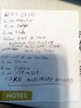
The instructions I wrote out for the Tron path.
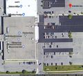
To get to the hash, I have to drive in front of the buildings and then take the first aisle past the island.
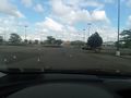
Driving up to the hash, it's directly in front of me next to the tree on the right.
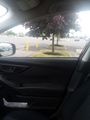
Driving through the hash, a view of the tree right next to it.
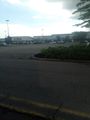
As I'm leaving the lot, a look back at the Tops storefront.

A blurry stupid grin before navigating home.


Ribbons
This user earned the Land geohash achievement
|
Pedalpusher earned the Tron achievement
|
Pedalpusher earned the No Batteries Geohash Achievement
|