Difference between revisions of "2018-07-01 51 9"
From Geohashing
imported>GeorgDerReisende (expedition report for Bad Emstal-Sand) |
imported>FippeBot m (Location) |
||
| (One intermediate revision by one other user not shown) | |||
| Line 1: | Line 1: | ||
| + | {{meetup graticule|lat=51|lon=9|date=2018-07-01}} | ||
| + | |||
<!-- edit as necessary --> | <!-- edit as necessary --> | ||
__NOTOC__ | __NOTOC__ | ||
| Line 38: | Line 40: | ||
[[Category:Not reached - Mother Nature]] | [[Category:Not reached - Mother Nature]] | ||
| + | {{location|DE|HE|KS}} | ||
Latest revision as of 03:47, 16 August 2019
| Sun 1 Jul 2018 in 51,9: 51.2461185, 9.2520957 geohashing.info google osm bing/os kml crox |
Location
The hash lay on a slope in Bad Emstal-Sand.
Participants
Plans
Taking the bus to Bad Emstal and walking to the hash.
Expedition
I went to a wrong bus stop and didn't find my bus, but by accident this bus passed by and I waved my hand and the bus stopped. With this bus I travelled to Bad Emstal and there I found the hash on an area looking like some mud in between and a lot of dry grass, nettles and thistles and I was not prepared. I walked around to the other side, but I didn't find a gate of access and I gave up.
Photos
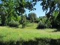
from this side
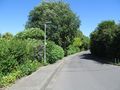
from the other side

