Difference between revisions of "2018-07-03 31 35"
imported>Yosef (→Location) |
imported>Fippe m (This page has already been categorised, so I removed category:new report.) |
||
| (10 intermediate revisions by 2 users not shown) | |||
| Line 25: | Line 25: | ||
<!-- who attended: If you link to your wiki user name in this section, your expedition will be picked up by the various statistics generated for geohashing. You may use three tildes ~ as a shortcut to automatically insert the user signature of the account you are editing with. | <!-- who attended: If you link to your wiki user name in this section, your expedition will be picked up by the various statistics generated for geohashing. You may use three tildes ~ as a shortcut to automatically insert the user signature of the account you are editing with. | ||
--> | --> | ||
| + | [[User:Yosef|Yosef]] ([[User talk:Yosef|talk]]) | ||
== Plans == | == Plans == | ||
<!-- what were the original plans --> | <!-- what were the original plans --> | ||
| + | Head over on my way home from work. It looks like the best place to park is on the south side of the stream and the hashpoint is on the north side of the stream so I will have to find a way to cross it. | ||
== Expedition == | == Expedition == | ||
<!-- how it all turned out. your narrative goes here. --> | <!-- how it all turned out. your narrative goes here. --> | ||
| + | |||
| + | This was a pretty challenging hashpoint. In fact it might have been the most challenging I have ever done. I had to make a few attempts to figure out the correct path because of the lack of trails. On my way home from work I decided I could stop at the nature reserve and see how I could get to the hashpoint. Google Maps had the point north of the dry creek when in reality it was to the south. | ||
| + | |||
| + | At the beginning my goal was to find a shortcut across the north side of the dry creek by bushwhacking and using branching trails which weren't on the map. This clearly did not work. I tried one time where I went into the middle of nowhere and another time where I found a trail that simply cut across the forest to a part of the road SOUTH of the creek. I then wandered around to the north side of the creek, but the trails which weren't really trails looked way too steep for me to consider them. | ||
| + | |||
| + | My traditional hike down the trail and then bushwhack up strategy had to be put into action. I took the main trail down (with some guidance from a fellow hiker coming up) and quite quickly made it to the creek. There was a half-circle of rocks next to the creek bed which was of course dry but forested. It looked good enough so I walked in. | ||
| + | |||
| + | The creek bed was heavily forested so the going was quite thorny. Partway through, I started finding cars. Lots and lots of cars. They looked like cars that had fallen off of the cliff above into the creek. I think I climbed over about four. Nightfall was on the way and so I finished with a light three meter climb up the SOUTH creek bank, took my screen shot, forgot my selfie, and quickly headed back. I reached the trail as the last sunlight had faded away. | ||
| + | |||
| + | The way back is always easier when you recognize it and I was able to get home without incident even though I was somewhat scared until I made it to my car. I prayed the whole time I wouldn't break an ankle on the rocks. | ||
== Tracklog == | == Tracklog == | ||
| Line 40: | Line 52: | ||
--> | --> | ||
<gallery perrow="5"> | <gallery perrow="5"> | ||
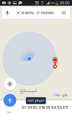
| + | Image:Screenshot 2018-07-03-19-59-12.png | proof on one side | ||
| + | Image:20180703 192517.jpg | ||
| + | Image:20180703 190312 386.jpg | ||
| + | Image:20180703 181151.jpg | ||
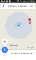
| + | Image:Screenshot 2018-07-03-20-00-25.png | proof on other side | ||
| + | Image:Screenshot 2018-07-03-20-00-21.png | more proof | ||
</gallery> | </gallery> | ||
| Line 46: | Line 64: | ||
<!-- Add any achievement ribbons you earned below, or remove this section --> | <!-- Add any achievement ribbons you earned below, or remove this section --> | ||
| − | |||
| − | |||
| − | |||
| − | |||
| − | |||
| − | |||
| − | |||
| − | |||
| − | |||
| − | |||
| − | |||
| − | |||
| − | |||
| − | |||
[[Category:Expeditions]] | [[Category:Expeditions]] | ||
| − | |||
[[Category:Expeditions with photos]] | [[Category:Expeditions with photos]] | ||
| − | |||
| − | |||
| − | |||
| − | |||
| − | |||
[[Category:Coordinates reached]] | [[Category:Coordinates reached]] | ||
| − | + | {{location|IL|JM}} | |
| − | |||
| − | |||
| − | |||
| − | |||
| − | |||
| − | |||
| − | |||
| − | |||
| − | |||
| − | |||
| − | |||
| − | |||
| − | |||
| − | |||
| − | |||
| − | |||
| − | |||
Latest revision as of 12:21, 25 July 2019
| Tue 3 Jul 2018 in 31,35: 31.7342526, 35.0815512 geohashing.info google osm bing/os kml crox |
Location
Qetalav Stream near Bar Giyora.
Participants
Plans
Head over on my way home from work. It looks like the best place to park is on the south side of the stream and the hashpoint is on the north side of the stream so I will have to find a way to cross it.
Expedition
This was a pretty challenging hashpoint. In fact it might have been the most challenging I have ever done. I had to make a few attempts to figure out the correct path because of the lack of trails. On my way home from work I decided I could stop at the nature reserve and see how I could get to the hashpoint. Google Maps had the point north of the dry creek when in reality it was to the south.
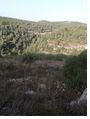
At the beginning my goal was to find a shortcut across the north side of the dry creek by bushwhacking and using branching trails which weren't on the map. This clearly did not work. I tried one time where I went into the middle of nowhere and another time where I found a trail that simply cut across the forest to a part of the road SOUTH of the creek. I then wandered around to the north side of the creek, but the trails which weren't really trails looked way too steep for me to consider them.
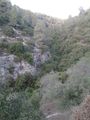
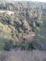
My traditional hike down the trail and then bushwhack up strategy had to be put into action. I took the main trail down (with some guidance from a fellow hiker coming up) and quite quickly made it to the creek. There was a half-circle of rocks next to the creek bed which was of course dry but forested. It looked good enough so I walked in.
The creek bed was heavily forested so the going was quite thorny. Partway through, I started finding cars. Lots and lots of cars. They looked like cars that had fallen off of the cliff above into the creek. I think I climbed over about four. Nightfall was on the way and so I finished with a light three meter climb up the SOUTH creek bank, took my screen shot, forgot my selfie, and quickly headed back. I reached the trail as the last sunlight had faded away.
The way back is always easier when you recognize it and I was able to get home without incident even though I was somewhat scared until I made it to my car. I prayed the whole time I wouldn't break an ankle on the rocks.
Tracklog
Photos
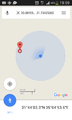
proof on one side
proof on other side
more proof


