Difference between revisions of "2018-07-16 -35 149"
imported>Felix Dance ([live picture]Geohash success! [http://www.openstreetmap.org/?lat=-35.41476990&lon=149.14342240&zoom=16&layers=B000FTF @-35.4148,149.1434]) |
imported>FippeBot m (Location) |
||
| (5 intermediate revisions by 2 users not shown) | |||
| Line 1: | Line 1: | ||
| − | |||
| − | |||
| − | |||
| − | |||
| − | |||
| − | |||
| − | |||
| − | |||
| − | |||
{{meetup graticule | {{meetup graticule | ||
| lat=-35 | | lat=-35 | ||
| Line 14: | Line 5: | ||
| date=2018-07-16 | | date=2018-07-16 | ||
}} | }} | ||
| − | |||
| − | |||
| − | |||
== Location == | == Location == | ||
| − | + | In Gilmore Paddocks, a park next a freeway near the souther-eastern border of the ACT with NSW. | |
== Participants == | == Participants == | ||
| − | + | *[[User:Felix Dance|Felix Dance]] | |
| − | |||
| − | == | + | == Expedition == |
| − | + | Not much to this one - I'd finished my contract role on the Canberra tram project, so had some free time during the week, and took on this fairly easy geohash. | |
| − | + | Heading off on the bike, I made a beeline for the hash, navigating a few bike paths and freeways to get there, until I crossed the road, negotiated some dumped rubbish, climbed a small, barbed wire fence, and reached the hash. | |
| − | + | ||
| + | I didn't take any wet weather gear this time, and watched from the hashy hillside the rainy clouds roll past on their way to Queanbeyan. I took off towards them. | ||
| + | |||
| + | I went round the back to Queanbeyan where I sat in a river-side cafe to have my iced-coffee and white chocolate cheesecake before heading home to O'Connor. | ||
| − | + | [https://goo.gl/maps/f4csdGGFkQ82 Here] is the route I took. | |
| − | |||
== Photos == | == Photos == | ||
| − | |||
| − | |||
| − | |||
<gallery perrow="5"> | <gallery perrow="5"> | ||
Image:2018-07-16_-35_149_Felix Dance_1531709958135.jpg|Geohash success! [http://www.openstreetmap.org/?lat=-35.41476990&lon=149.14342240&zoom=16&layers=B000FTF @-35.4148,149.1434] | Image:2018-07-16_-35_149_Felix Dance_1531709958135.jpg|Geohash success! [http://www.openstreetmap.org/?lat=-35.41476990&lon=149.14342240&zoom=16&layers=B000FTF @-35.4148,149.1434] | ||
| + | |||
| + | Image:2018-07-16_-35_149_Felix Dance_1531709979942.jpg|GPS proof | ||
| + | |||
| + | Image:2018-07-16_-35_149_Felix Dance_1531710006231.jpg|Looking back towards my bike | ||
| + | |||
| + | Image:2018-07-16_-35_149_Felix Dance_1531710043643.jpg|Stormy weather over Queanbeyan | ||
</gallery> | </gallery> | ||
== Achievements == | == Achievements == | ||
| − | |||
| − | |||
| − | + | {{bicycle geohash | |
| − | |||
| − | |||
| − | + | | latitude = -35 | |
| + | | longitude = 149 | ||
| + | | date = 2018-07-16 | ||
| + | | name = [[User:Felix Dance|Felix Dance]] | ||
| + | | distance = 58kms | ||
| + | | bothways = true | ||
| + | | image = 2018-07-16_-35_149_Felix Dance_1531710006231.jpg | ||
| − | + | }} | |
| − | |||
| − | |||
| − | |||
| − | |||
| − | |||
| − | |||
[[Category:Expeditions]] | [[Category:Expeditions]] | ||
| − | |||
[[Category:Expeditions with photos]] | [[Category:Expeditions with photos]] | ||
| − | |||
| − | |||
| − | |||
| − | |||
| − | |||
[[Category:Coordinates reached]] | [[Category:Coordinates reached]] | ||
| − | + | {{location|AU|ACT}} | |
| − | |||
| − | |||
| − | |||
| − | |||
| − | |||
| − | |||
| − | |||
| − | |||
| − | |||
| − | |||
| − | |||
| − | |||
| − | |||
| − | |||
| − | |||
| − | |||
| − | |||
Latest revision as of 03:50, 16 August 2019
| Mon 16 Jul 2018 in -35,149: -35.4147721, 149.1434305 geohashing.info google osm bing/os kml crox |
Location
In Gilmore Paddocks, a park next a freeway near the souther-eastern border of the ACT with NSW.
Participants
Expedition
Not much to this one - I'd finished my contract role on the Canberra tram project, so had some free time during the week, and took on this fairly easy geohash.
Heading off on the bike, I made a beeline for the hash, navigating a few bike paths and freeways to get there, until I crossed the road, negotiated some dumped rubbish, climbed a small, barbed wire fence, and reached the hash.
I didn't take any wet weather gear this time, and watched from the hashy hillside the rainy clouds roll past on their way to Queanbeyan. I took off towards them.
I went round the back to Queanbeyan where I sat in a river-side cafe to have my iced-coffee and white chocolate cheesecake before heading home to O'Connor.
Here is the route I took.
Photos
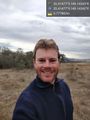
Geohash success! @-35.4148,149.1434
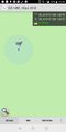
GPS proof
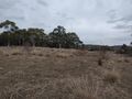
Looking back towards my bike
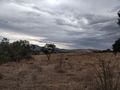
Stormy weather over Queanbeyan


Achievements
Felix Dance earned the Bicycle geohash achievement
|