Difference between revisions of "2018-07-19 49 8"
imported>DODO ([live picture]Happy Häuser. success. [http://www.openstreetmap.org/?lat=49.39259170&lon=8.57477750&zoom=16&layers=B000FTF @49.3926,8.5748]) |
imported>FippeBot m (Location) |
||
| (7 intermediate revisions by one other user not shown) | |||
| Line 20: | Line 20: | ||
== Location == | == Location == | ||
<!-- where you've surveyed the hash to be --> | <!-- where you've surveyed the hash to be --> | ||
| + | A harvested field next to Schwetzingen. | ||
== Participants == | == Participants == | ||
<!-- who attended: If you link to your wiki user name in this section, your expedition will be picked up by the various statistics generated for geohashing. You may use three tildes ~ as a shortcut to automatically insert the user signature of the account you are editing with. | <!-- who attended: If you link to your wiki user name in this section, your expedition will be picked up by the various statistics generated for geohashing. You may use three tildes ~ as a shortcut to automatically insert the user signature of the account you are editing with. | ||
--> | --> | ||
| + | [[User:DODO|DODO]] | ||
== Plans == | == Plans == | ||
<!-- what were the original plans --> | <!-- what were the original plans --> | ||
| + | Only 3 KM from my office (as the crow flies). To easy, not to try. | ||
| + | But I forgot to go there in the morning, so I had to drive there after work on my way to the rowing club (although it's in the opposite direction). | ||
== Expedition == | == Expedition == | ||
<!-- how it all turned out. your narrative goes here. --> | <!-- how it all turned out. your narrative goes here. --> | ||
| + | Not much to tell. Had to drive 4.5 KM. There was a parking area next to the hashfield. So I left my car 90 m from the hashpoint. The field was already harvested, so I did not even had to take care for plants. I was back in my car in less than 5 minutes and continued my way to the rowing club. Well, I took a wrong turn twice on that way, but both times were easy to fix. | ||
| + | All in all one of my fastest success stories, with an effort of around 15 minutes. | ||
== Tracklog == | == Tracklog == | ||
<!-- if your GPS device keeps a log, you may post a link here --> | <!-- if your GPS device keeps a log, you may post a link here --> | ||
| + | [https://www.komoot.de/tour/39305283 9 KM by car and 200 m by foot] | ||
== Photos == | == Photos == | ||
| Line 40: | Line 47: | ||
<gallery perrow="5"> | <gallery perrow="5"> | ||
| − | Image:2018-07-19_49_8_DODO_1532014323889.jpg|Happy | + | Image:2018-07-19_49_8_DODO_1532014323889.jpg|Happy Hasher. Success. [http://www.openstreetmap.org/?lat=49.39259170&lon=8.57477750&zoom=16&layers=B000FTF @49.3926,8.5748] |
</gallery> | </gallery> | ||
== Achievements == | == Achievements == | ||
{{#vardefine:ribbonwidth|800px}} | {{#vardefine:ribbonwidth|800px}} | ||
| − | + | {{land geohash | |
| + | | latitude = 49 | ||
| + | | longitude = 8 | ||
| + | | date = 2018-07-19 | ||
| + | | name = DODO | ||
| + | }} | ||
| − | |||
| − | |||
| − | |||
| − | |||
| − | |||
| − | |||
| − | |||
| − | |||
| − | |||
| − | |||
| − | |||
| − | |||
| − | |||
[[Category:Expeditions]] | [[Category:Expeditions]] | ||
| − | |||
[[Category:Expeditions with photos]] | [[Category:Expeditions with photos]] | ||
| − | |||
| − | |||
| − | |||
| − | |||
| − | |||
[[Category:Coordinates reached]] | [[Category:Coordinates reached]] | ||
| − | + | {{location|DE|BW|HD}} | |
| − | |||
| − | |||
| − | |||
| − | |||
| − | |||
| − | |||
| − | |||
| − | |||
| − | |||
| − | |||
| − | |||
| − | |||
| − | |||
| − | |||
| − | |||
| − | |||
| − | |||
Latest revision as of 03:51, 16 August 2019
| Thu 19 Jul 2018 in 49,8: 49.3925996, 8.5747742 geohashing.info google osm bing/os kml crox |
Location
A harvested field next to Schwetzingen.
Participants
Plans
Only 3 KM from my office (as the crow flies). To easy, not to try. But I forgot to go there in the morning, so I had to drive there after work on my way to the rowing club (although it's in the opposite direction).
Expedition
Not much to tell. Had to drive 4.5 KM. There was a parking area next to the hashfield. So I left my car 90 m from the hashpoint. The field was already harvested, so I did not even had to take care for plants. I was back in my car in less than 5 minutes and continued my way to the rowing club. Well, I took a wrong turn twice on that way, but both times were easy to fix. All in all one of my fastest success stories, with an effort of around 15 minutes.
Tracklog
Photos
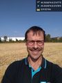
Happy Hasher. Success. @49.3926,8.5748

Achievements
DODO earned the Land geohash achievement
|