Difference between revisions of "2018-07-21 52 5"
From Geohashing
imported>Xnyhps |
imported>Xnyhps |
||
| Line 1: | Line 1: | ||
| + | [[Image:{{{image|2018-07-21 52 5 The point.jpeg}}}|thumb|left]] | ||
| − | |||
| − | |||
| − | |||
| − | |||
| − | |||
| − | |||
| − | |||
| − | |||
| − | |||
{{meetup graticule | {{meetup graticule | ||
| lat=52 | | lat=52 | ||
| Line 36: | Line 28: | ||
<gallery perrow="5"> | <gallery perrow="5"> | ||
Image:2018-07-21 52 52 Proof.jpeg | Why not a screen shot? Long story. | Image:2018-07-21 52 52 Proof.jpeg | Why not a screen shot? Long story. | ||
| − | |||
Image:2018-07-21 52 5 Panorama.jpeg | View from the lookout tower. | Image:2018-07-21 52 5 Panorama.jpeg | View from the lookout tower. | ||
</gallery> | </gallery> | ||
| − | |||
| − | |||
| − | |||
[[Category:Expeditions]] | [[Category:Expeditions]] | ||
[[Category:Expeditions with photos]] | [[Category:Expeditions with photos]] | ||
[[Category:Coordinates reached]] | [[Category:Coordinates reached]] | ||
Revision as of 20:12, 21 July 2018

| Sat 21 Jul 2018 in 52,5: 52.0432936, 5.3567632 geohashing.info google osm bing/os kml crox |
Location
In the forest near Doorn, The Netherlands.
Participants
Plans
We wanted to take a walk, so we decided to go for the geohash, as it seemed to be in a nice bit of forest right next to a footpath.
Expedition
We drove by car to the Sint Helenalaan, where we could park near the cafe Helenaheuvel, then we walked to the hashpoint. It was very close to the path, made it to within 20 cm without leaving the path. Then, we walked a bit further to the east to the Doornse Kaap, a lookout tower, and then back to the car.
Photos
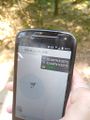
Why not a screen shot? Long story.
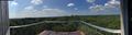
View from the lookout tower.
