Difference between revisions of "2018-07-21 52 5"
imported>Xnyhps (Created page with "{{subst:Expedition |lat = 52 |lon = 5 |date = 2018-07-21 }}") |
imported>FippeBot m (Location) |
||
| (6 intermediate revisions by 2 users not shown) | |||
| Line 1: | Line 1: | ||
| + | [[Image:{{{image|2018-07-21 52 5 The point.jpeg}}}|thumb|left]] | ||
| − | |||
| − | |||
| − | |||
| − | |||
| − | |||
| − | |||
| − | |||
| − | |||
| − | |||
{{meetup graticule | {{meetup graticule | ||
| lat=52 | | lat=52 | ||
| Line 19: | Line 11: | ||
== Location == | == Location == | ||
| − | + | In the forest near Doorn, The Netherlands. | |
== Participants == | == Participants == | ||
| − | + | [[User:Xnyhps|Xnyhps]] ([[User talk:Xnyhps|talk]]) | |
| − | + | ||
| + | [[User:FelixTheCat|FelixTheCat]] ([[User talk:FelixTheCat|talk]]) | ||
== Plans == | == Plans == | ||
| − | + | ===Xnyhps=== | |
| + | We wanted to take a walk, so we decided to go for the geohash, as it seemed to be in a nice bit of forest right next to a footpath. | ||
| + | |||
| + | ===FelixTheCat=== | ||
| + | As usual, drive to the hash and attempt to reach it. | ||
== Expedition == | == Expedition == | ||
| − | + | ===Xnyhps=== | |
| − | + | We drove by car to the Sint Helenalaan, where we could park near the cafe Helenaheuvel at around 14:00, then we walked to the hashpoint. It was very close to the path, made it to within 20 cm without leaving the path. Then, we walked a bit further to the east to the Doornse Kaap, a lookout tower, and then back to the car. | |
| − | == | + | ===FelixTheCat=== |
| − | + | I arrived at the car park at around 9:00. There were not many people around and the forest was pretty quiet. The hash was easy to reach, right next to a footpath. No crawling through thick bushes and over fallen trees this time. I took some photos and then explored the forest a bit more, taking some pictures of the Great Boulder of Doorn and climbing up the tower. Afterwards I went on to visit some museums in towns nearby. | |
== Photos == | == Photos == | ||
| − | < | + | ===Xnyhps=== |
| − | Image: | + | <gallery perrow="5"> |
| − | --> | + | Image:2018-07-21 52 52 Proof.jpeg | Why not a screen shot? Long story. |
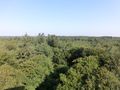
| + | Image:2018-07-21 52 5 Panorama.jpeg | View from the lookout tower. | ||
| + | </gallery> | ||
| + | ===FelixTheCat=== | ||
<gallery perrow="5"> | <gallery perrow="5"> | ||
| + | Image:2018-07-21 52 5 FelixTheCat 1.JPG | The car park, still mostly empty. | ||
| + | Image:2018-07-21 52 5 FelixTheCat 2.JPG | The path leading into the forest. | ||
| + | Image:2018-07-21 52 5 FelixTheCat 3.JPG | Looking at the hash. | ||
| + | Image:2018-07-21 52 5 FelixTheCat 4.png | GPS proof. | ||
| + | Image:2018-07-21 52 5 FelixTheCat 5.JPG | Lloyd celebrating another success. | ||
| + | Image:2018-07-21 52 5 FelixTheCat 6.JPG | The Great Boulder of Doorn. A glacial erratic, quite common in this area. | ||
| + | Image:2018-07-21 52 5 FelixTheCat 7.JPG | The watchtower. | ||
| + | Image:2018-07-21 52 5 FelixTheCat 8.JPG | Looking towards the hash from atop the tower. | ||
</gallery> | </gallery> | ||
| − | |||
| − | |||
| − | |||
| − | |||
| − | |||
| − | |||
| − | |||
| − | |||
| − | |||
| − | |||
| − | |||
| − | |||
| − | |||
| − | |||
| − | |||
| − | |||
| − | |||
| − | |||
| − | |||
[[Category:Expeditions]] | [[Category:Expeditions]] | ||
| − | |||
[[Category:Expeditions with photos]] | [[Category:Expeditions with photos]] | ||
| − | |||
| − | |||
| − | |||
| − | |||
| − | |||
[[Category:Coordinates reached]] | [[Category:Coordinates reached]] | ||
| − | + | {{location|NL|UT}} | |
| − | |||
| − | |||
| − | |||
| − | |||
| − | |||
| − | |||
| − | |||
| − | |||
| − | |||
| − | |||
| − | |||
| − | |||
| − | |||
| − | |||
| − | |||
| − | |||
| − | |||
Latest revision as of 03:51, 16 August 2019

| Sat 21 Jul 2018 in 52,5: 52.0432936, 5.3567632 geohashing.info google osm bing/os kml crox |
Location
In the forest near Doorn, The Netherlands.
Participants
Plans
Xnyhps
We wanted to take a walk, so we decided to go for the geohash, as it seemed to be in a nice bit of forest right next to a footpath.
FelixTheCat
As usual, drive to the hash and attempt to reach it.
Expedition
Xnyhps
We drove by car to the Sint Helenalaan, where we could park near the cafe Helenaheuvel at around 14:00, then we walked to the hashpoint. It was very close to the path, made it to within 20 cm without leaving the path. Then, we walked a bit further to the east to the Doornse Kaap, a lookout tower, and then back to the car.
FelixTheCat
I arrived at the car park at around 9:00. There were not many people around and the forest was pretty quiet. The hash was easy to reach, right next to a footpath. No crawling through thick bushes and over fallen trees this time. I took some photos and then explored the forest a bit more, taking some pictures of the Great Boulder of Doorn and climbing up the tower. Afterwards I went on to visit some museums in towns nearby.
Photos
Xnyhps
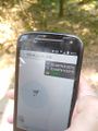
Why not a screen shot? Long story.
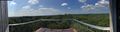
View from the lookout tower.

FelixTheCat
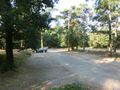
The car park, still mostly empty.
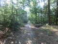
The path leading into the forest.
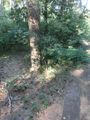
Looking at the hash.
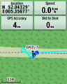
GPS proof.
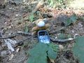
Lloyd celebrating another success.
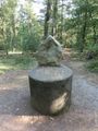
The Great Boulder of Doorn. A glacial erratic, quite common in this area.
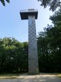
The watchtower.
Looking towards the hash from atop the tower.


