2018-08-05 52 13
| Sun 5 Aug 2018 in 52,13: 52.6209120, 13.5142391 geohashing.info google osm bing/os kml crox |
Location
In a field near Buch.
Participants
Plans
I was visiting Berlin for the weekend and had been eyeing this point since Friday. Public transit looked promising.
- Might adventure out to this later in the day -- Coyotebush (talk) 11:06, 5 August 2018 (GMT+02:00)
Expedition
Sunday had refreshingly comfortable weather, and my host was out of town for the day, so I bought a public transit day pass and headed to the center of the city to walk around and see some of the tourist sites: the Reichstag, Brandenburg Gate, Holocaust Memorial, Checkpoint Charlie, and several cathedrals. After all of that, my legs were tired and my phone battery was running low from all of the photography... but the time was only 14:30 and the weather was still nice.
So I headed for the point. Google Maps sent me on the S2 line as far as Blankenburg (currently the last stop due to some sort of track work) and then north on the 150 bus.
- Catching a bus to near the point -- Coyotebush (talk) @52.5911,13.4417 15:23, 5 August 2018 (GMT+02:00)
In the interest of preserving my battery, I kept the route more or less memorized: get off at Theodor-Brugsch-Straße, walk to its end and jog left to Lindenberger Weg, stop when I reach the power lines.
(to be continued)
Tracklog
Photos
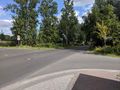
Where the sidewalk ends...
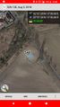
Made it, just before my battery died


Achievements