Difference between revisions of "2018-08-13 51 -0"
imported>Saxbophone (→Plans) |
imported>FippeBot m (Location) |
||
| (7 intermediate revisions by 3 users not shown) | |||
| Line 15: | Line 15: | ||
}} | }} | ||
| − | + | ||
__NOTOC__ | __NOTOC__ | ||
== Location == | == Location == | ||
| − | + | ||
Anglia House Car Park, Salmon Lane, Limehouse, London, UK. | Anglia House Car Park, Salmon Lane, Limehouse, London, UK. | ||
The hash location is in the middle of the car park for Anglia House, a high rise block of flats. | The hash location is in the middle of the car park for Anglia House, a high rise block of flats. | ||
| − | It's probable that Geohashers have no business venturing into this car park, however Geohashers ought to be able to get close enough at the Zebra | + | It's probable that Geohashers have no business venturing into this car park, however Geohashers ought to be able to get close enough at the [https://en.wikipedia.org/wiki/Zebra_crossing Zebra Crossing] just in front of it. |
== Participants == | == Participants == | ||
| − | + | ||
| − | + | * [[User:Saxbophone|Saxbophone]] | |
| − | * [[User:Saxbophone|Saxbophone]] | + | * [[User:Tongs/B|Tongs/B]] |
| − | * [[User:Tongs/B|Tongs/B]] | ||
== Plans == | == Plans == | ||
| − | + | ||
| − | * [[User:Saxbophone|Saxbophone]] Plans to travel to Limehouse Station by train, meet [[User:Tongs/B|Tongs/B]] there at 19:30 and then proceed together on foot to a site very close to the hash, at the | + | * [[User:Saxbophone|Saxbophone]] Plans to travel to Limehouse Station by train, meet [[User:Tongs/B|Tongs/B]] there at 19:30 and then proceed together on foot to a site very close to the hash, at the Zebra Crossing located just outside of Anglia House. |
== Expedition == | == Expedition == | ||
| − | + | ||
| + | === [[User:Saxbophone|Saxbophone]] === | ||
| + | I used a combination of [https://en.wikipedia.org/wiki/London_Underground Tube], [https://en.wikipedia.org/wiki/National_Rail National Rail] and the [https://en.wikipedia.org/wiki/Docklands_Light_Railway DLR] to get to Limehouse Station. Travelling on the DLR is always a real treat for me (it's an extensive automated light rail system concentrated around the Docklands Business District in East London) so this was a highly enjoyable journey towards the end where I had to use it. It was also a strange journey for me as the first part of the journey was exactly the same as the journey I used to make to go to work! | ||
| + | |||
| + | I arrived at Limehouse station a little early, so warmed up my GPS in the meantime and waited for [[User:Tongs/B]] to arrive. Once we greeted eachother we proceeded in a casual fashion in the approximate direction of the hash, only to get a little sidetracked chatting and had to double-back on ourselves a little bit. We were both pleased to come across [https://en.wikipedia.org/wiki/Regent%27s_Canal Regent's Canal] and utilised it to get near the hash, before returning to the local roads and soon arrived pretty much exactly at the hash (we declined to venture any closer as the exact hashpoint was within a residential car park, in which we decided we had no business going). | ||
| + | |||
| + | After a quick photo of us and our proof at the hash, we decided to wander on, continuing along Regent's Canal. Having frequently walked other parts of Regent's Canal before, I was glad for the opportunity to explore a part of it I hadn't been to before. We had a very enjoyable chat throughout our wander and decided to leave the canal at [https://en.wikipedia.org/wiki/Victoria_Park,_London Victoria Park] and head for [https://en.wikipedia.org/wiki/Brick_Lane Brick Lane], which is a popular market area with good places to eat. | ||
| + | |||
| + | In Brick Lane, we went to a restaurant and had some falafel wraps to eat and during this supper we also exchanged the necessary details to allow us to later sign eachother's PGP keys. | ||
| + | |||
| + | At this point, it was getting quite late so Tongs/B and I headed for Liverpool Street before going our separate ways. What an eventful and enjoyable Geohash this has been! | ||
| + | |||
| + | === [[User:Tongs/B|Tongs/B]] === | ||
| + | |||
| + | In my mind, this expedition had all the elements that make any geohashing expedition complete. | ||
| + | |||
| + | Firstly and secondly, | ||
| + | ''the combination of going to the point'' and ''having an adventure afterwards''. After meeting at Limehouse station, we took a short unintended detour around Limehouse marina before going on a | ||
| + | less circuitous route. Sadly, as advertised, [http://www.moocanoes.com/ Moocanoes] was indeed closed so my suggestion of an evening paddle was definitely off the cards. We got to the point, agreeing that we didn't want to bother | ||
| + | residents by going into their car park, and called the hashpoint a success. Briefly considering whether to go to a nearly Grade II listed pub or walk along the canal, we both strongly agreed that a | ||
| + | canalside walk would be a fine idea. I had just started working in the area and the walk took in what I'm sure will become a nice lunchtime walk during some of the days remaining this summer, as well | ||
| + | as the corner of a nice park. The third element was ''learning something new about the place you live''. Saxbophone had lived in London all of his life and taught me a lot about the city I'd come to | ||
| + | be living in. | ||
| + | |||
| + | Fourthly, of course, ''it involved meeting another geohasher''. Saxbophone and I turned out to have a lot of interests in common. We chatted for the three or four hours that the expedition lasted. | ||
| + | We even [http://xkcd.com/364/ signed each other's public key] and had a meal at [http://www.brick-lane.com/food-drink/restaurants/damascu-bite/ Damascu Bite in Brick Lane] together before walking back to Liverpool Street station and then home. | ||
== Tracklog == | == Tracklog == | ||
| Line 43: | Line 67: | ||
== Photos == | == Photos == | ||
| − | |||
| − | |||
| − | |||
<gallery perrow="5"> | <gallery perrow="5"> | ||
| + | Image:2018-08-13 51 -0 proof.jpg | The 'proof', showing 8m distance from the point. | ||
| + | Image:2018-08-13 51 -0 canal.jpg | The nearby canal. | ||
| + | Image:2018-08-13 51 -0 goose.jpg | A friendly goose. | ||
| + | Image:2018-08-13 51 -0 cat.jpg | A friendly cat. | ||
| + | Image:Saxbophone 2018-08-13 51 -0 Tracklog.jpg | The route we took to the hash. | ||
</gallery> | </gallery> | ||
| Line 53: | Line 79: | ||
<!-- Add any achievement ribbons you earned below, or remove this section --> | <!-- Add any achievement ribbons you earned below, or remove this section --> | ||
| − | + | * Land Geohash | |
| − | |||
| − | |||
| − | |||
| − | + | [[Category:Expeditions with photos]] | |
| − | |||
| − | |||
| − | |||
| − | |||
| − | |||
| − | |||
| − | |||
[[Category:Expeditions]] | [[Category:Expeditions]] | ||
| − | |||
| − | |||
| − | |||
| − | |||
| − | |||
| − | |||
| − | |||
[[Category:Coordinates reached]] | [[Category:Coordinates reached]] | ||
| − | + | {{location|GB|ENG|TWH}} | |
| − | |||
| − | |||
| − | |||
| − | |||
| − | |||
| − | |||
| − | |||
| − | |||
| − | |||
| − | |||
| − | |||
| − | |||
| − | |||
| − | |||
| − | |||
| − | |||
| − | |||
Latest revision as of 03:13, 7 August 2019
| Mon 13 Aug 2018 in 51,-0: 51.5139561, -0.0362408 geohashing.info google osm bing/os kml crox |
Location
Anglia House Car Park, Salmon Lane, Limehouse, London, UK.
The hash location is in the middle of the car park for Anglia House, a high rise block of flats.
It's probable that Geohashers have no business venturing into this car park, however Geohashers ought to be able to get close enough at the Zebra Crossing just in front of it.
Participants
Plans
- Saxbophone Plans to travel to Limehouse Station by train, meet Tongs/B there at 19:30 and then proceed together on foot to a site very close to the hash, at the Zebra Crossing located just outside of Anglia House.
Expedition
Saxbophone
I used a combination of Tube, National Rail and the DLR to get to Limehouse Station. Travelling on the DLR is always a real treat for me (it's an extensive automated light rail system concentrated around the Docklands Business District in East London) so this was a highly enjoyable journey towards the end where I had to use it. It was also a strange journey for me as the first part of the journey was exactly the same as the journey I used to make to go to work!
I arrived at Limehouse station a little early, so warmed up my GPS in the meantime and waited for User:Tongs/B to arrive. Once we greeted eachother we proceeded in a casual fashion in the approximate direction of the hash, only to get a little sidetracked chatting and had to double-back on ourselves a little bit. We were both pleased to come across Regent's Canal and utilised it to get near the hash, before returning to the local roads and soon arrived pretty much exactly at the hash (we declined to venture any closer as the exact hashpoint was within a residential car park, in which we decided we had no business going).
After a quick photo of us and our proof at the hash, we decided to wander on, continuing along Regent's Canal. Having frequently walked other parts of Regent's Canal before, I was glad for the opportunity to explore a part of it I hadn't been to before. We had a very enjoyable chat throughout our wander and decided to leave the canal at Victoria Park and head for Brick Lane, which is a popular market area with good places to eat.
In Brick Lane, we went to a restaurant and had some falafel wraps to eat and during this supper we also exchanged the necessary details to allow us to later sign eachother's PGP keys.
At this point, it was getting quite late so Tongs/B and I headed for Liverpool Street before going our separate ways. What an eventful and enjoyable Geohash this has been!
Tongs/B
In my mind, this expedition had all the elements that make any geohashing expedition complete.
Firstly and secondly, the combination of going to the point and having an adventure afterwards. After meeting at Limehouse station, we took a short unintended detour around Limehouse marina before going on a less circuitous route. Sadly, as advertised, Moocanoes was indeed closed so my suggestion of an evening paddle was definitely off the cards. We got to the point, agreeing that we didn't want to bother residents by going into their car park, and called the hashpoint a success. Briefly considering whether to go to a nearly Grade II listed pub or walk along the canal, we both strongly agreed that a canalside walk would be a fine idea. I had just started working in the area and the walk took in what I'm sure will become a nice lunchtime walk during some of the days remaining this summer, as well as the corner of a nice park. The third element was learning something new about the place you live. Saxbophone had lived in London all of his life and taught me a lot about the city I'd come to be living in.
Fourthly, of course, it involved meeting another geohasher. Saxbophone and I turned out to have a lot of interests in common. We chatted for the three or four hours that the expedition lasted. We even signed each other's public key and had a meal at Damascu Bite in Brick Lane together before walking back to Liverpool Street station and then home.
Tracklog
Photos
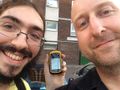
The 'proof', showing 8m distance from the point.
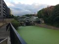
The nearby canal.

A friendly goose.

A friendly cat.
The route we took to the hash.


Achievements
- Land Geohash