Difference between revisions of "2018-08-20 50 9"
imported>Digiphono (→Expedition) |
imported>Digiphono (→Achievements) |
||
| Line 56: | Line 56: | ||
{{#vardefine:ribbonwidth|800px}} | {{#vardefine:ribbonwidth|800px}} | ||
<!-- Add any achievement ribbons you earned below, or remove this section --> | <!-- Add any achievement ribbons you earned below, or remove this section --> | ||
| + | {{consecutive geohash 2 | ||
| + | |||
| + | | count = 2 | ||
| + | | latitude = 51 | ||
| + | | longitude = 9 | ||
| + | | date = 2018-08-19 | ||
| + | | name = Digiphono | ||
| + | |||
| + | }} | ||
<!-- =============== USEFUL CATEGORIES FOLLOW ================ | <!-- =============== USEFUL CATEGORIES FOLLOW ================ | ||
Delete the next line ONLY if you have chosen the appropriate categories below. If you are unsure, don't worry. People will read your report and help you with the classification. --> | Delete the next line ONLY if you have chosen the appropriate categories below. If you are unsure, don't worry. People will read your report and help you with the classification. --> | ||
| − | |||
<!-- ==REQUEST FOR TWITTER BOT== Please leave either the New report or the Expedition planning category in as long as you work on it. This helps the twitter bot a lot with announcing the right outcome at the right moment. --> | <!-- ==REQUEST FOR TWITTER BOT== Please leave either the New report or the Expedition planning category in as long as you work on it. This helps the twitter bot a lot with announcing the right outcome at the right moment. --> | ||
| − | |||
| − | |||
| − | |||
| − | |||
| − | |||
| − | |||
| − | |||
| − | |||
[[Category:Expeditions]] | [[Category:Expeditions]] | ||
| − | |||
[[Category:Expeditions with photos]] | [[Category:Expeditions with photos]] | ||
| − | |||
| − | |||
| − | |||
| − | |||
| − | |||
[[Category:Coordinates reached]] | [[Category:Coordinates reached]] | ||
| − | |||
| − | |||
| − | |||
| − | |||
| − | |||
| − | |||
| − | |||
| − | |||
| − | |||
| − | |||
| − | |||
| − | |||
| − | |||
| − | |||
| − | |||
| − | |||
| − | |||
| − | |||
Revision as of 15:55, 20 August 2018
| Mon 20 Aug 2018 in 50,9: 50.9663033, 9.5936990 geohashing.info google osm bing/os kml crox |
Location
In a forest, south-east of the village Ersrode.
Participants
Plans
After my early shift I will try to make it to this geohash at around 15:00 pm. The hash is some 25 km / 30 minutes south of the place where I work, so I think I may give it a try...
Expedition
Right after work I drove to this little village called Ersrode and parked my car at the end of a road. From there I walked the last one kilometer to the hash on a nice path through the forest. The final 75 meters were going directly into the woods, and I was surprised to discover an old logging trail, leading me straight to the hash! Lucky me! This trail wasn't on any map, so no one actually goes here normally, but it made it an easy expedition for me! I took some pics and then went back to my car - the expedition took only 30 minutes ;-)
Tracklog
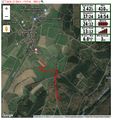
Todays track

Photos
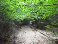
The last few meters to the hash
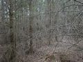
The hash is down there at the tree stump

Proof
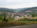
Nice view on Ersrode
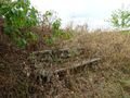
Have a seat and relax


Achievements
Digiphono earned the Consecutive geohash achievement
|